Home
Weather London
WeatherRadar
RainfallRadar
TemperatureRadar
WindRadar
LightningRadar
Weather News
Editor's Pick
Discover the app
Weather widget
Contact us
Apps
Career
    Home / Editor's Pick /

    Yet more rain and winds - Unsettled midweek weather

10:43
10 September 2025

Yet more rain and winds
Unsettled midweek weather

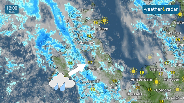
Weather map of the UK and parts of Europe showing scattered rain bands, especially over Ireland, Wales, and northern England, with blue shading indicating rainfall. Temperatures range from 15–18°C across the UK, with brighter, sunnier conditions shown over much of mainland Europe. An icon highlights rain over Ireland moving north-east.
Rain and showers during the day.

Unsettled conditions continue on Wednesday, with rain and winds picking up from Tuesday.

This is due to the first of a series of low-pressure systems passing by the UK and Ireland. Bringing bands of rain across Ireland in the early morning, moving into the UK towards the afternoon following showers.

Wind gusts are also expected to reach around 40 mph in some areas, including Dublin and Aberdeen.

As winds grow stronger during the day, wind warnings are live for parts of Ireland and the UK, though mostly across Scotland.

Check conditions on the WeatherRadar
Ryan Hathaway
More on the topic
A marked change in the weather. Cold front heading south. . . Monday, 7 September 2026
Map of Europe showing a cold front stretching from Scandinavia to Spain. Thunderstorms are shown in southern and central Europe.
Monday, 7 September 2026

Cold front heading south

A marked change in the weather
Autumn arrives with vivid colour. Your weather - Your shots. . . Sunday, 6 September 2026
Split image showing peach-lit textured clouds above silhouetted trees and golden cumulus clouds reflected in a calm canal lined with boats.
Sunday, 6 September 2026

Your weather - Your shots

Autumn arrives with vivid colour
Severe weather hits Mallorca and Italy. Severe thunderstorms. . . Thursday, 10 September 2026
Numerous thunderstorms are sweeping across La Palma. The many lightning symbols on the radar and lightning map show that there is heavy lightning activity across large parts of the island. The thunderstorms are striking particularly in the island’s interior and in the south. On the right, you can see the aftermath: a large fallen tree has buried a car beneath it. Emergency services are clearing up the damage. So, along with the thunderstorms, not only heavy rain but also gusts of wind can become a problem.
Thursday, 10 September 2026

Severe thunderstorms

Severe weather hits Mallorca and Italy
All weather news
This might also interest you
New records for England and Wales. Broken again tomorrow?. . . Thursday, 25 June 2026
Temperature map of southwest Britain on 25.06 showing extreme heat across southern Wales and southwest England, with Bute Park in Cardiff highlighted at 34.2°C and Yeovilton at 36.4°C amid widespread deep red heat zones.
Thursday, 25 June 2026

Broken again tomorrow?

New records for England and Wales
A frozen start to the weekend. Icy conditions. . . Friday, 13 February 2026
UK temperature map dated 14.02 showing widespread subzero values in blue shading, with readings such as −4 in Glasgow, −3 in Dublin, and −2 in London, alongside a blue thermometer icon.
Friday, 13 February 2026

Icy conditions

A frozen start to the weekend
Seasonal warmth between spring thunder. Your weather - Your shots. . . Sunday, 19 April 2026
Split image showing coastal sunset with layered lenticular clouds over rooftops and palm trees on the left, and a green valley with river and hills under soft daylight on the right.
Sunday, 19 April 2026

Your weather - Your shots

Seasonal warmth between spring thunder
All articles
Weather & Radar

Weather & Radar is also available on

Google Play StoreApp Store

Company

Contact us Privacy Policy Legal info Accessibility statement

Services

Uploader

Socials

facebooktwittertikToklinkList