Home
Weather London
WeatherRadar
RainfallRadar
TemperatureRadar
WindRadar
LightningRadar
Weather News
Editor's Pick
Discover the app
Weather widget
Contact us
Apps
Career
    Home / Editor's Pick /

    Winter in South America: Frost instead of a heatwave

10:49
26 June 2026

Winter in South America
Frost instead of a heatwave

A historic heatwave has swept across large parts of Europe. Meanwhile, the Southern Hemisphere is in the depths of winter with cold polar air and frost.

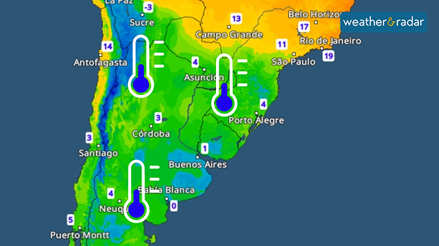
In South America, a cold front has brought a significant drop in temperatures over the past few days. In southern Brazil, a massive drop in temperature has even led to sub-zero temperatures and ground frost.

TemperatureRadar: Cool air has reached Argentina and southern Brazil.

A new record was even set in São Paulo. On Thursday, the temperature there did not exceed 13.5 °C. This is the lowest maximum temperature recorded for the month of June in the last 30 years.

The cool air is set to linger over the regions for a while longer. Temperatures in the Argentine capital, Buenos Aires, are unlikely to rise above 10 to 15 °C in the coming days. It is particularly chilly at night.

Buenos Aires

We
11
16
Th
9
17
Fr
15
22
Sa
16
17
Su
9
16
Mo
12
15
Tu
10
15
We
12
17
Th
9
14
Fr
8
14
Sa
7
14
Su
5
13
Mo
4
12
Tu
7
14
Max (°C)
Min (°C)
moreless

Córdoba

We
13
15
Th
12
17
Fr
16
28
Sa
13
20
Su
9
19
Mo
12
20
Tu
12
19
We
12
20
Th
8
16
Fr
8
20
Sa
7
17
Su
6
17
Mo
5
16
Tu
6
17
Max (°C)
Min (°C)
moreless

Montevideo

We
10
14
Th
7
17
Fr
12
20
Sa
16
16
Su
8
15
Mo
9
14
Tu
12
14
We
11
15
Th
10
13
Fr
9
14
Sa
9
13
Su
6
12
Mo
6
11
Tu
7
13
Max (°C)
Min (°C)
moreless

Porto Alegre

We
16
21
Th
15
21
Fr
14
26
Sa
15
29
Su
17
19
Mo
16
23
Tu
18
23
We
15
24
Th
17
21
Fr
15
18
Sa
13
18
Su
10
15
Mo
9
16
Tu
11
18
Max (°C)
Min (°C)
moreless

Rio Grande

We
15
17
Th
13
17
Fr
16
18
Sa
16
22
Su
14
14
Mo
14
18
Tu
16
18
We
14
18
Th
14
17
Fr
11
17
Sa
11
15
Su
8
14
Mo
9
14
Tu
9
15
Max (°C)
Min (°C)
moreless
Clemens Teutsch-Zumtobel
More on the topic
Forest fires are getting out of control. Spain and France. . . Saturday, 25 July 2026
A split-screen image featuring a photograph and a weather map. On the left, thick, dark-grey smoke rises from several fire sites in a wooded coastal area; a calm stretch of water can be seen in the foreground. On the right, a weather map shows south-western France and northern Spain. A red arrow points from the Atlantic towards the French Atlantic coast, symbolising an onshore wind. Sunny weather is forecast for Bordeaux at around 20 degrees, and Bilbao is also expected to be sunny at around 27 degrees. A large warning sign with a flame symbol indicates an increased risk of forest fires.
Saturday, 25 July 2026

Spain and France

Forest fires are getting out of control
Heat becoming a bigger factor in drought. New study. . . Thursday, 23 July 2026
A hand holds dry, dusty earth above a parched field. The ground is cracked and covered with plant debris – a sign of prolonged drought.
Thursday, 23 July 2026

New study

Heat becoming a bigger factor in drought
Icy spells in the Southern Hemisphere. Snow in the Andes. . . Tuesday, 28 July 2026
A composite image showing a temperature radar map of South America and a snow-covered town in Chile. The winter cold is bringing heavy snowfall to the Andes and, in some areas, snow down to lower altitudes.
Tuesday, 28 July 2026

Snow in the Andes

Icy spells in the Southern Hemisphere
All weather news
This might also interest you
New records for England and Wales. Broken again tomorrow?. . . Thursday, 25 June 2026
Temperature map of southwest Britain on 25.06 showing extreme heat across southern Wales and southwest England, with Bute Park in Cardiff highlighted at 34.2°C and Yeovilton at 36.4°C amid widespread deep red heat zones.
Thursday, 25 June 2026

Broken again tomorrow?

New records for England and Wales
Super Typhoon Bavi threatens Taiwan. Up to 1,000 mm of rain. . . Wednesday, 8 July 2026
The image shows an intense tropical cyclone over the western Pacific, east of Taiwan and the Philippines. The centre of the system is depicted as a light purple and white vortex with a clearly visible eye, surrounded by a ring of red and orange areas indicating the strongest wind speeds. A white arrow marks the typhoon’s predicted track towards the north-west, in the direction of Taiwan. To the west of the storm lie the Philippines, with the cities of Manila and Cebu; to the north of these lies Taiwan, with Taipei. Further west, the Chinese coast, including Hong Kong, and parts of Vietnam can be seen. The coloured wind map shows predominantly green areas outside the storm’s core, indicating significantly weaker winds. White streamlines illustrate the typhoon’s anti-clockwise circulation in the Northern Hemisphere. The highest wind speeds are concentrated around the eye of the cyclone.
Wednesday, 8 July 2026

Up to 1,000 mm of rain

Super Typhoon Bavi threatens Taiwan
Long-term trends need a pinch of salt. 40 °C in July?. . . Tuesday, 30 June 2026
Temperature radar of 2022 heatwave where the all-time temperature record in the UK was set. Warning symbol overlain.
Tuesday, 30 June 2026

40 °C in July?

Long-term trends need a pinch of salt
All articles
Weather & Radar

Weather & Radar is also available on

Google Play StoreApp Store

Company

Contact us Privacy Policy Legal info Accessibility statement

Services

Uploader

Socials

facebooktwittertikToklinkList