Home
Weather London
WeatherRadar
RainfallRadar
TemperatureRadar
WindRadar
LightningRadar
Weather News
Editor's Pick
Discover the app
Weather widget
Contact us
Apps
Career
    Home / Weather News /

    Windy in the west with spells of rain

04:00
2 September 2024

Breakfast brief
Windy in the west with spells of rain

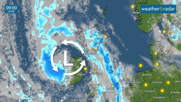
The unsettled theme persists to start the new week with further blustery, showery spells of rain.

Kickstarting your morning

Welcome to the breakfast brief, offering your daily weather forecast and a sneak peek at the day's news.

Weather outlook

Further showery spells of rain are expected, potentially thundery in nature, particularly across eastern fringes of the UK. Increasing bright spells breaking through later.

Rain will also push into the west coast of Ireland, where some strong winds are expected to gust around 40 mph, perhaps locally nearer to 50 mph in spots.

What's coming up in the news

The first weather trend of the week arrives later this afternoon, while we're staying on top of the latest news in weather at home and abroad throughout the day.

Did you miss these?

Hurricanes seen on radar and satellite
The latest collection of user images
2024/25 storm names released

Shot from the world

Every morning, we take a trip across the world courtesy of our international users around the globe!

We share shots from the UK and Ireland every Sunday right here, and throughout the week on our social channels.

If you want to get involved, just tap the image icon in the app, or use one of our dedicated uploaders for the UK and Ireland.

Weather & Radar editorial team
More on the topic
Lightning strikes in dry conditions. Positive earth flashes. . . Monday, 17 August 2026
On the left, massive thunderclouds are gathering at night, with several flashes of lightning streaking from them. On the right, a map shows the Ligurian coast near Genoa and Savona. Numerous coloured dots over the Ligurian Sea and along the coast indicate lightning activity.
Monday, 17 August 2026

Positive earth flashes

Lightning strikes in dry conditions
Drought brings flash flood risks. As rain returns. . . Wednesday, 19 August 2026
Weather radar map of the UK and Ireland showing widespread showers, with a rain icon and flood warning symbol highlighting the risk from rainfall.
Wednesday, 19 August 2026

As rain returns

Drought brings flash flood risks
Record warmth in the Mediterranean. High water temperatures. . . Tuesday, 18 August 2026
Split graphic showing a hot southern Europe temperature map beside a sunny Mediterranean beach, with a sea-temperature icon highlighting very warm coastal waters.
Tuesday, 18 August 2026

High water temperatures

Record warmth in the Mediterranean
All weather news
This might also interest you
Long-term trends need a pinch of salt. 40 °C in July?. . . Tuesday, 30 June 2026
Temperature radar of 2022 heatwave where the all-time temperature record in the UK was set. Warning symbol overlain.
Tuesday, 30 June 2026

40 °C in July?

Long-term trends need a pinch of salt
A frozen start to the weekend. Icy conditions. . . Friday, 13 February 2026
UK temperature map dated 14.02 showing widespread subzero values in blue shading, with readings such as −4 in Glasgow, −3 in Dublin, and −2 in London, alongside a blue thermometer icon.
Friday, 13 February 2026

Icy conditions

A frozen start to the weekend
Super Typhoon Bavi threatens Taiwan. Up to 1,000 mm of rain. . . Wednesday, 8 July 2026
The image shows an intense tropical cyclone over the western Pacific, east of Taiwan and the Philippines. The centre of the system is depicted as a light purple and white vortex with a clearly visible eye, surrounded by a ring of red and orange areas indicating the strongest wind speeds. A white arrow marks the typhoon’s predicted track towards the north-west, in the direction of Taiwan. To the west of the storm lie the Philippines, with the cities of Manila and Cebu; to the north of these lies Taiwan, with Taipei. Further west, the Chinese coast, including Hong Kong, and parts of Vietnam can be seen. The coloured wind map shows predominantly green areas outside the storm’s core, indicating significantly weaker winds. White streamlines illustrate the typhoon’s anti-clockwise circulation in the Northern Hemisphere. The highest wind speeds are concentrated around the eye of the cyclone.
Wednesday, 8 July 2026

Up to 1,000 mm of rain

Super Typhoon Bavi threatens Taiwan
All articles
Weather & Radar

Weather & Radar is also available on

Google Play StoreApp Store

Company

Contact us Privacy Policy Legal info Accessibility statement

Services

Uploader

Socials

facebooktwittertikToklinkList