Home
Weather London
WeatherRadar
RainfallRadar
TemperatureRadar
WindRadar
LightningRadar
Weather News
Editor's Pick
Discover the app
Weather widget
Contact us
Apps
Career
    Home / Editor's Pick /

    Widespread thunderstorm risk in the UK, heavy rain and hail too

12:18
25 August 2026

Heavy rain and hail too
Widespread thunderstorm risk in the UK

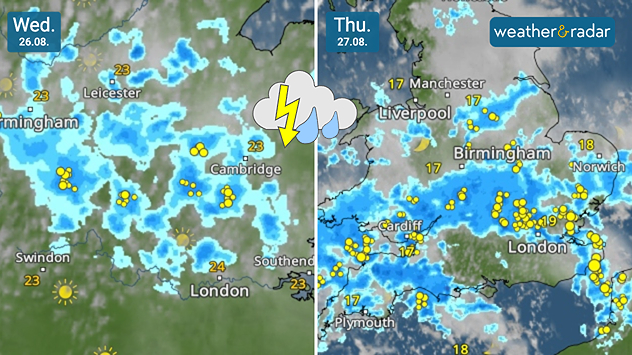
Split weather maps for Wednesday 26.08 and Thursday 27.08 showing showers and thunderstorms spreading across England and Wales, with frequent lightning around London and southeast England on Thursday.
Thunderstorms are likely to break out from Wednesday.

Weather warnings for thunderstorms have been issued for Wednesday and Thursday with a risk of flooding also rising.

Yellow thunderstorm warnings come into effect early Wednesday morning, covering large parts of England from East Anglia through to the West Midlands. Eastern Wales is also included before the warning area expands on Thursday across Wales.

The area of heavy rain moves northwards from the early hours of Wednesday bringing rainfall accumulation of up to 50 mm in parts. Large hailstones are also possible before the first bout of the stormy conditions eases in the evening.

Thursday sees potential for heavier rainfall, potentially up to 75 mm in areas at altitude. More widely rain accumulation of up to 30 mm is likely.

Thundery outbreaks continue along with conditions ripe for more large hail. With much of England and Wales still in drought, parched ground is likely to increase run-off resulting in flash flooding.

The conditions will help alleviate the overall drought, with some 29 million people still under a form of water use restriction, despite presenting immediate flooding issues.

Keep an eye on the conditionsWeatherRadar
Ryan Hathaway
More on the topic
Warm weather despite the start of autumn. Temperatures worldwide. . . Wednesday, 23 September 2026
Temperature Radar for the Northern Hemisphere
Wednesday, 23 September 2026

Temperatures worldwide

Warm weather despite the start of autumn
Severe weather rolls on in Europe. Heavy rain and hail. . . Thursday, 17 September 2026
Weather radar showing severe thunderstorms and frequent lightning over northern Italy.
Thursday, 17 September 2026

Heavy rain and hail

Severe weather rolls on in Europe
Hurricane threat off the coast of Mexico. Storm and rain. . . Monday, 21 September 2026
Split image showing a powerful tropical system southwest of Acapulco on a wind map and palm trees bending sharply in strong winds.
Monday, 21 September 2026

Storm and rain

Hurricane threat off the coast of Mexico
All weather news
This might also interest you
Historic Storm Éowyn arrives. On this day.... . . Saturday, 24 January 2026
Split image showing a person in a yellow jacket struggling against strong winds and heavy rain on a street at night on the left, and an Irish wind forecast map on the right with red and purple shading, gusts up to 75 mph, and a wind warning icon, divided by a curved white line.
Saturday, 24 January 2026

On this day...

Historic Storm Éowyn arrives
New records for England and Wales. Broken again tomorrow?. . . Thursday, 25 June 2026
Temperature map of southwest Britain on 25.06 showing extreme heat across southern Wales and southwest England, with Bute Park in Cardiff highlighted at 34.2°C and Yeovilton at 36.4°C amid widespread deep red heat zones.
Thursday, 25 June 2026

Broken again tomorrow?

New records for England and Wales
Flooding, gales, and heavy snow. Storm Chandra. . . Tuesday, 27 January 2026
Split image showing aerial flooding in a town with muddy water covering roads on the left, and a rural road on the right blocked by heavy snowfall with vans stopped and a person walking in snow.
Tuesday, 27 January 2026

Storm Chandra

Flooding, gales, and heavy snow
All articles
Weather & Radar

Weather & Radar is also available on

Google Play StoreApp Store

Company

Contact us Privacy Policy Legal info Accessibility statement

Services

Uploader

Socials

facebooktwittertikToklinkList