Home
Weather London
WeatherRadar
RainfallRadar
TemperatureRadar
WindRadar
LightningRadar
Weather News
Editor's Pick
Discover the app
Weather widget
Contact us
Apps
Career
    Home / Editor's Pick /

    Wetter days to come? - Marine heatwave could affect our weather

09:23
15 July 2026

Wetter days to come?
Marine heatwave could affect our weather too

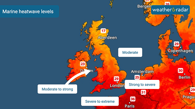
Marine heatwave map showing waters around the UK and Ireland alongside nearby Europe, with sea heatwave levels ranging from around northern Britain to moderate to strong west of Ireland, severe to extreme in the English Channel, and strong to severe in the southern North Sea.
Early July marine heatwave levels around the UK and Ireland.

Sea temperatures around the UK are higher than usual, with some areas seeing an extreme marine heatwave. This deviation from the norm will have consequences for our weather too.

Since early July, sea surface temperatures across north-western Europe, including the UK and Ireland, have been experiencing strong to severe marine heatwaves.

Sea surface anomalies off the coasts of Wales and England have reached as high as 5°C above average, while more widely temperatures are around 2°C above normal for the time of year.

How does a marine heatwave affect our weather?

While the immediate impacts of heatwaves in the water are felt by the marine life around our coasts, the unusually warm seas can also have a knock-on effect on our weather.

Over the coming weeks, elevated sea surface temperatures can result in higher humidity, warmer nights without as cooling sea breezes become less effective, heavier rainfall when frontal systems return, and stronger thunderstorms if conditions are right.

While there is little rainfall in the forecast right now, any system that does arrive will likely be enhanced thanks to the warmer and more humid air it travels over en-route to the UK and Ireland.

June heatwave also warmed the watersread more
Ryan Hathaway

More on the topic

Europe set for a change in the weather. Turning more unsettled. . . Monday, 9 November 2026
European weather map showing low pressure over Scandinavia, pink snow bands across Norway and Sweden, blue rain areas and arrows indicating airflow.
Monday, 9 November 2026

Turning more unsettled

Europe set for a change in the weather
Gloomy evening with a few spots of rain. Bonfire Night. . . Thursday, 5 November 2026
Split image showing a cloudy UK weather map with temperatures of 8–9°C alongside colourful fireworks bursting through smoke in the night sky.
Thursday, 5 November 2026

Bonfire Night

Gloomy evening with a few spots of rain
Heavy rain again in the south of France. Another bout of disruption. . . Wednesday, 4 November 2026
Split image showing heavy rain and lightning near Montpellier, Marseille and Monaco on a weather map, alongside cars stranded on a flooded road.
Wednesday, 4 November 2026

Another bout of disruption

Heavy rain again in the south of France
All weather news

This might also interest you

Historic Storm Éowyn arrives. On this day.... . . Saturday, 24 January 2026
Split image showing a person in a yellow jacket struggling against strong winds and heavy rain on a street at night on the left, and an Irish wind forecast map on the right with red and purple shading, gusts up to 75 mph, and a wind warning icon, divided by a curved white line.
Saturday, 24 January 2026

On this day...

Historic Storm Éowyn arrives
Super Typhoon Bavi threatens Taiwan. Up to 1,000 mm of rain. . . Wednesday, 8 July 2026
The image shows an intense tropical cyclone over the western Pacific, east of Taiwan and the Philippines. The centre of the system is depicted as a light purple and white vortex with a clearly visible eye, surrounded by a ring of red and orange areas indicating the strongest wind speeds. A white arrow marks the typhoon’s predicted track towards the north-west, in the direction of Taiwan. To the west of the storm lie the Philippines, with the cities of Manila and Cebu; to the north of these lies Taiwan, with Taipei. Further west, the Chinese coast, including Hong Kong, and parts of Vietnam can be seen. The coloured wind map shows predominantly green areas outside the storm’s core, indicating significantly weaker winds. White streamlines illustrate the typhoon’s anti-clockwise circulation in the Northern Hemisphere. The highest wind speeds are concentrated around the eye of the cyclone.
Wednesday, 8 July 2026

Up to 1,000 mm of rain

Super Typhoon Bavi threatens Taiwan
A frozen start to the weekend. Icy conditions. . . Friday, 13 February 2026
UK temperature map dated 14.02 showing widespread subzero values in blue shading, with readings such as −4 in Glasgow, −3 in Dublin, and −2 in London, alongside a blue thermometer icon.
Friday, 13 February 2026

Icy conditions

A frozen start to the weekend
All articles
Weather & Radar

Weather & Radar is also available on

Google Play StoreApp Store

Company

Contact us Privacy Policy Legal info Accessibility statement

Services

Uploader

Socials

facebooktwittertikToklinkList