Home
Weather London
WeatherRadar
RainfallRadar
TemperatureRadar
WindRadar
LightningRadar
Weather News
Editor's Pick
Discover the app
Weather widget
Contact us
Apps
Career
    Home / Editor's Pick /

    Wetter days to come? - Marine heatwave could affect our weather

09:23
15 July 2026

Wetter days to come?
Marine heatwave could affect our weather too

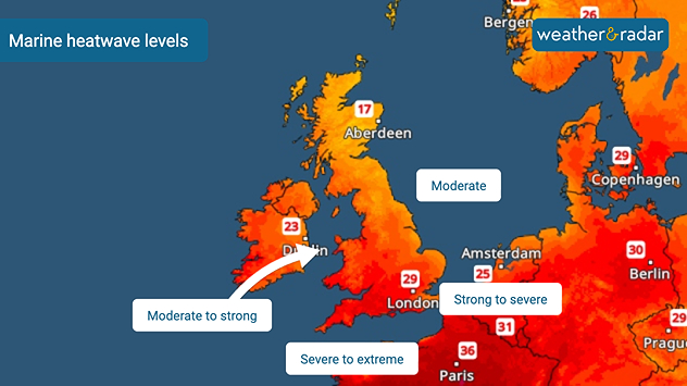
Marine heatwave map showing waters around the UK and Ireland alongside nearby Europe, with sea heatwave levels ranging from around northern Britain to moderate to strong west of Ireland, severe to extreme in the English Channel, and strong to severe in the southern North Sea.
Early July marine heatwave levels around the UK and Ireland.

Sea temperatures around the UK are higher than usual, with some areas seeing an extreme marine heatwave. This deviation from the norm will have consequences for our weather too.

Since early July, sea surface temperatures across north-western Europe, including the UK and Ireland, have been experiencing strong to severe marine heatwaves.

Sea surface anomalies off the coasts of Wales and England have reached as high as 5°C above average, while more widely temperatures are around 2°C above normal for the time of year.

How does a marine heatwave affect our weather?

While the immediate impacts of heatwaves in the water are felt by the marine life around our coasts, the unusually warm seas can also have a knock-on effect on our weather.

Over the coming weeks, elevated sea surface temperatures can result in higher humidity, warmer nights without as cooling sea breezes become less effective, heavier rainfall when frontal systems return, and stronger thunderstorms if conditions are right.

While there is little rainfall in the forecast right now, any system that does arrive will likely be enhanced thanks to the warmer and more humid air it travels over en-route to the UK and Ireland.

June heatwave also warmed the watersread more
Ryan Hathaway
More on the topic
Severe weather hits Mallorca and Italy. Severe thunderstorms. . . Thursday, 10 September 2026
Numerous thunderstorms are sweeping across La Palma. The many lightning symbols on the radar and lightning map show that there is heavy lightning activity across large parts of the island. The thunderstorms are striking particularly in the island’s interior and in the south. On the right, you can see the aftermath: a large fallen tree has buried a car beneath it. Emergency services are clearing up the damage. So, along with the thunderstorms, not only heavy rain but also gusts of wind can become a problem.
Thursday, 10 September 2026

Severe thunderstorms

Severe weather hits Mallorca and Italy
A marked change in the weather. Cold front heading south. . . Monday, 7 September 2026
Map of Europe showing a cold front stretching from Scandinavia to Spain. Thunderstorms are shown in southern and central Europe.
Monday, 7 September 2026

Cold front heading south

A marked change in the weather
More rain needed to ease drought. Reservoirs still falling. . . Tuesday, 8 September 2026
Aerial view of a depleted reservoir with exposed banks and a narrow winding stream through the dry basin, surrounded by green hills and roads.
Tuesday, 8 September 2026

Reservoirs still falling

More rain needed to ease drought
All weather news
This might also interest you
New records for England and Wales. Broken again tomorrow?. . . Thursday, 25 June 2026
Temperature map of southwest Britain on 25.06 showing extreme heat across southern Wales and southwest England, with Bute Park in Cardiff highlighted at 34.2°C and Yeovilton at 36.4°C amid widespread deep red heat zones.
Thursday, 25 June 2026

Broken again tomorrow?

New records for England and Wales
Seasonal warmth between spring thunder. Your weather - Your shots. . . Sunday, 19 April 2026
Split image showing coastal sunset with layered lenticular clouds over rooftops and palm trees on the left, and a green valley with river and hills under soft daylight on the right.
Sunday, 19 April 2026

Your weather - Your shots

Seasonal warmth between spring thunder
Historic Storm Éowyn arrives. On this day.... . . Saturday, 24 January 2026
Split image showing a person in a yellow jacket struggling against strong winds and heavy rain on a street at night on the left, and an Irish wind forecast map on the right with red and purple shading, gusts up to 75 mph, and a wind warning icon, divided by a curved white line.
Saturday, 24 January 2026

On this day...

Historic Storm Éowyn arrives
All articles
Weather & Radar

Weather & Radar is also available on

Google Play StoreApp Store

Company

Contact us Privacy Policy Legal info Accessibility statement

Services

Uploader

Socials

facebooktwittertikToklinkList