Home
Weather London
WeatherRadar
RainfallRadar
TemperatureRadar
WindRadar
LightningRadar
Weather News
Editor's Pick
Discover the app
Weather widget
Contact us
Apps
Career
    Home / Editor's Pick /

    Weekend pressure change - Return of unsettled conditions

14:00
16 October 2025

Weekend pressure change
Return of unsettled conditions

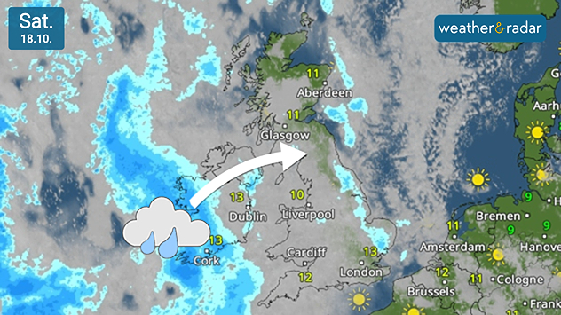
Weather map of the UK and Ireland showing a band of rain over the Atlantic moving eastwards towards Ireland and western Britain. Blue areas indicate rainfall approaching Cork, with an arrow pointing towards Glasgow. Temperatures range from 10°C to 13°C across the region under mostly cloudy skies.
Widespread rain moves in on Saturday.

After a period of settled, dull weather under high pressure, things change over the weekend as a low moves in.

From Saturday, widespread rain returns, first moving through Ireland and into the UK later in the day and overnight.

By Saturday evening and throughout Sunday, the pressure system is positioned west of Ireland. This results in strong gusts reaching up to 50 mph (80 km/h) in Dublin early Sunday.

By the afternoon, gusts are widespread across the UK as well as Ireland, though slightly weaker than the initial force felt at night.

Ryan Hathaway
More on the topic
Severe weather in the Mediterranean. Is a medicane on the way?. . . Monday, 14 September 2026
A weather map shows a powerful low-pressure system over the Mediterranean, with warning symbols for storms and heavy rain.
Monday, 14 September 2026

Is a medicane on the way?

Severe weather in the Mediterranean
Autumn colours light the skies. Your weather - Your shots. . . Sunday, 13 September 2026
Split image showing a fiery red-orange sunset over a rural road and fields beside a golden sea sunset with a silhouetted seabird in flight.
Sunday, 13 September 2026

Your weather - Your shots

Autumn colours light the skies
Severe weather hits Mallorca and Italy. Severe thunderstorms. . . Thursday, 10 September 2026
Numerous thunderstorms are sweeping across La Palma. The many lightning symbols on the radar and lightning map show that there is heavy lightning activity across large parts of the island. The thunderstorms are striking particularly in the island’s interior and in the south. On the right, you can see the aftermath: a large fallen tree has buried a car beneath it. Emergency services are clearing up the damage. So, along with the thunderstorms, not only heavy rain but also gusts of wind can become a problem.
Thursday, 10 September 2026

Severe thunderstorms

Severe weather hits Mallorca and Italy
All weather news
This might also interest you
New records for England and Wales. Broken again tomorrow?. . . Thursday, 25 June 2026
Temperature map of southwest Britain on 25.06 showing extreme heat across southern Wales and southwest England, with Bute Park in Cardiff highlighted at 34.2°C and Yeovilton at 36.4°C amid widespread deep red heat zones.
Thursday, 25 June 2026

Broken again tomorrow?

New records for England and Wales
Flooding, gales, and heavy snow. Storm Chandra. . . Tuesday, 27 January 2026
Split image showing aerial flooding in a town with muddy water covering roads on the left, and a rural road on the right blocked by heavy snowfall with vans stopped and a person walking in snow.
Tuesday, 27 January 2026

Storm Chandra

Flooding, gales, and heavy snow
Bright and warm conditions take hold. Spring-like outlook. . . Thursday, 23 April 2026
Split UK map showing warm temperatures up to 21 degrees in orange on the left and clear sunny conditions with temperatures from 12 to 18 degrees on the right, with sun icons across the country.
Thursday, 23 April 2026

Spring-like outlook

Bright and warm conditions take hold
All articles
Weather & Radar

Weather & Radar is also available on

Google Play StoreApp Store

Company

Contact us Privacy Policy Legal info Accessibility statement

Services

Uploader

Socials

facebooktwittertikToklinkList