Home
Weather London
WeatherRadar
RainfallRadar
TemperatureRadar
WindRadar
LightningRadar
Weather News
Editor's Pick
Discover the app
Weather widget
Contact us
Apps
Career
    Home / Editor's Pick /

    Weekend pressure change - Return of unsettled conditions

14:00
16 October 2025

Weekend pressure change
Return of unsettled conditions

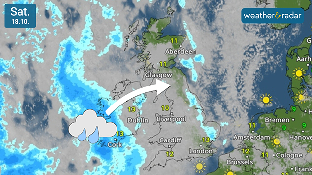
Weather map of the UK and Ireland showing a band of rain over the Atlantic moving eastwards towards Ireland and western Britain. Blue areas indicate rainfall approaching Cork, with an arrow pointing towards Glasgow. Temperatures range from 10°C to 13°C across the region under mostly cloudy skies.
Widespread rain moves in on Saturday.

After a period of settled, dull weather under high pressure, things change over the weekend as a low moves in.

From Saturday, widespread rain returns, first moving through Ireland and into the UK later in the day and overnight.

By Saturday evening and throughout Sunday, the pressure system is positioned west of Ireland. This results in strong gusts reaching up to 50 mph (80 km/h) in Dublin early Sunday.

By the afternoon, gusts are widespread across the UK as well as Ireland, though slightly weaker than the initial force felt at night.

Ryan Hathaway
More on the topic
Drought for North Wales and Upper Severn. 2% of average rainfall. . . Thursday, 23 July 2026
Split image showing a July rainfall anomaly map of Europe on the left with below-average rainfall across the UK, Ireland, and much of western and central Europe, and an active moorland wildfire on the right producing flames and thick smoke near homes.
Thursday, 23 July 2026

2% of average rainfall

Drought for North Wales and Upper Severn
Typhoon warning for China. Up to 500 mm of rain. . . Friday, 24 July 2026
Weather map of the southern Chinese coast and Taiwan showing a powerful tropical cyclone. The eye of the storm is located near the coastal city of Shantou in the Chinese province of Guangdong. Around the centre, intense shades of red, pink and violet indicate gale-force winds, whilst a large orange wind field extends as far as the west coast of Taiwan. An overlaid windsack warning sign indicates dangerous storm winds. Cities such as Hong Kong, Guangzhou, Xiamen, Taipei and Taichung are shown, as are wind speeds and white flow lines illustrating the cyclonic air circulation.
Friday, 24 July 2026

Up to 500 mm of rain

Typhoon warning for China
Icy spells in the Southern Hemisphere. Snow in the Andes. . . Tuesday, 28 July 2026
A composite image showing a temperature radar map of South America and a snow-covered town in Chile. The winter cold is bringing heavy snowfall to the Andes and, in some areas, snow down to lower altitudes.
Tuesday, 28 July 2026

Snow in the Andes

Icy spells in the Southern Hemisphere
All weather news
This might also interest you
Storm Chandra makes impact. Severe gales & heavy rain. . . Tuesday, 27 January 2026
Split image showing strong winds over the UK on a forecast map and widespread rain and snow on a weather radar map.
Tuesday, 27 January 2026

Severe gales & heavy rain

Storm Chandra makes impact
Historic Storm Éowyn arrives. On this day.... . . Saturday, 24 January 2026
Split image showing a person in a yellow jacket struggling against strong winds and heavy rain on a street at night on the left, and an Irish wind forecast map on the right with red and purple shading, gusts up to 75 mph, and a wind warning icon, divided by a curved white line.
Saturday, 24 January 2026

On this day...

Historic Storm Éowyn arrives
Turbulent weather in the Canary Islands. Storm and rain. . . Friday, 12 December 2025
Weather graphic showing rain and wind fields over the Canary Islands and a central warning symbol.
Friday, 12 December 2025

Storm and rain

Turbulent weather in the Canary Islands
All articles
Weather & Radar

Weather & Radar is also available on

Google Play StoreApp Store

Company

Contact us Privacy Policy Legal info Accessibility statement

Services

Uploader

Socials

facebooktwittertikToklinkList