Home
Weather London
WeatherRadar
RainfallRadar
TemperatureRadar
WindRadar
LightningRadar
Weather News
Editor's Pick
Discover the app
Weather widget
Contact us
Apps
Career
    Home / Editor's Pick /

    Weather warnings active - Torrential rainfall over Spain

13:40
4 March 2026

Weather warnings active
Torrential rainfall over Spain

A low-pressure system will bring heavy rainfall over the next few days, particularly in Spain.

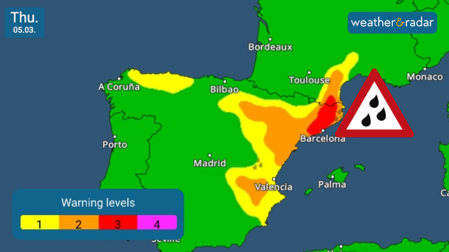
Along the Mediterranean coast from Valencia to Barcelona and the Pyrenees, rainfall will often reach 50 to 100 mm per square metre by the weekend. In the Pyrenees, local rainfall will exceed 200 mm.

Rainfall on the weather radarread more

There is heavy rainfall in the south of France and in north-western Spain too, such as in Galicia. Severe weather warnings are in place. The weather will also be very changeable in the Balearic Islands, Sardinia and Corsica.

Warning map of the Iberian Peninsula with colour-coded warning levels. Large parts of Spain are shown in green, while a yellow-orange-red band stretches from Valencia via Barcelona to the Toulouse area. In the north-east near Barcelona, the highest warning level is marked in red. A red warning triangle with raindrops additionally indicates heavy rain. A legend with warning levels 1 to 4 is displayed at the bottom left.

Due to the heavy rainfall, there is a risk of flooding and, especially in the mountains, landslides. Just last February, the Iberian Peninsula experienced flooding after heavy rainfall. Portugal and southern Spain were particularly affected.

Verena Leyendecker

More on the topic

Autumn is the season for fog. High pressure, but no sun. . . Thursday, 5 November 2026
A split-screen image showing the weather radar for Europe and a mountain landscape. On the right, snow-capped peaks rise above a thick blanket of fog against a blue sky.
Thursday, 5 November 2026

High pressure, but no sun

Autumn is the season for fog
Conditions combine to reduce air quality. Light winds and fireworks. . . Tuesday, 10 November 2026
Split image showing a UK wind map with 25 mph near Cardiff and 19 mph near London, beside colourful fireworks above illuminated waterfront buildings.
Tuesday, 10 November 2026

Light winds and fireworks

Conditions combine to reduce air quality
Gloomy evening with a few spots of rain. Bonfire Night. . . Thursday, 5 November 2026
Split image showing a cloudy UK weather map with temperatures of 8–9°C alongside colourful fireworks bursting through smoke in the night sky.
Thursday, 5 November 2026

Bonfire Night

Gloomy evening with a few spots of rain
All weather news

This might also interest you

A frozen start to the weekend. Icy conditions. . . Friday, 13 February 2026
UK temperature map dated 14.02 showing widespread subzero values in blue shading, with readings such as −4 in Glasgow, −3 in Dublin, and −2 in London, alongside a blue thermometer icon.
Friday, 13 February 2026

Icy conditions

A frozen start to the weekend
Bright and warm conditions take hold. Spring-like outlook. . . Thursday, 23 April 2026
Split UK map showing warm temperatures up to 21 degrees in orange on the left and clear sunny conditions with temperatures from 12 to 18 degrees on the right, with sun icons across the country.
Thursday, 23 April 2026

Spring-like outlook

Bright and warm conditions take hold
Seasonal warmth between spring thunder. Your weather - Your shots. . . Sunday, 19 April 2026
Split image showing coastal sunset with layered lenticular clouds over rooftops and palm trees on the left, and a green valley with river and hills under soft daylight on the right.
Sunday, 19 April 2026

Your weather - Your shots

Seasonal warmth between spring thunder
All articles
Weather & Radar

Weather & Radar is also available on

Google Play StoreApp Store

Company

Contact us Privacy Policy Legal info Accessibility statement

Services

Uploader

Socials

facebooktwittertikToklinkList