Home
Weather London
WeatherRadar
RainfallRadar
TemperatureRadar
WindRadar
LightningRadar
Weather News
Editor's Pick
Discover the app
Weather widget
Contact us
Apps
Career
    Home / Editor's Pick /

    Weather in Europe: Cold air intrusion in Eastern Europe with frost and snowfall

08:00
11 December 2025

Frost and snowfall
Cold air intrusion in Eastern Europe

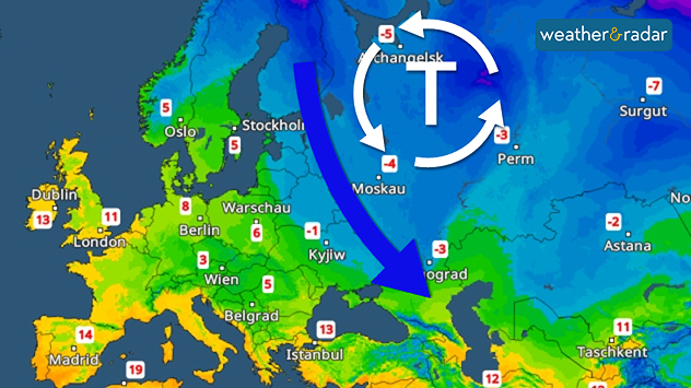
Temperature radar: A low-pressure system brings cold weather to the Black Sea.

A significant drop in temperature is imminent in Eastern Europe. Temperatures will plummet over the next few days.

Permanent frost is setting in, particularly in southern Finland, the Baltic States, Belarus, Ukraine and Russia. The thermometer will show temperatures below 0 degrees throughout the day.

Temperature drop in Eastern EuropeImpressive temperature radar

A low-pressure system is responsible for the cold air intrusion, transporting polar cold air to the Black Sea. It is also bringing snowfall. Up to 10 centimetres of fresh snow is expected locally by the weekend.

The winter weather will continue until the weekend. A strong north-westerly wind will make it feel even colder. Next week, the cold weather will then retreat slightly northwards again.

Kathrin Bogensperger
More on the topic
Temperature map of southeast England showing overnight low temperatures, with Kenley highlighted at 21.3°C and surrounding areas in yellow-orange shades indicating mild nighttime conditions.
Tuesday, 26 May 2026

May heatwave

Tropical night breaks overnight record
Split image showing a bright rainbow above a residential street on the left and a dramatic ocean sunrise with glowing clouds and reflections on the sea on the right.
Sunday, 24 May 2026

Your weather - Your shots

From unsettled to warm and toasty
On the left is the temperature radar, showing high temperatures across Western Europe. On the right is the weather radar, showing a high-pressure system.
Tuesday, 26 May 2026

Summer weather in spring

Heatwave sets new records in Europe too
All weather news
This might also interest you
Split image showing a person in a yellow jacket struggling against strong winds and heavy rain on a street at night on the left, and an Irish wind forecast map on the right with red and purple shading, gusts up to 75 mph, and a wind warning icon, divided by a curved white line.
Saturday, 24 January 2026

On this day...

Historic Storm Éowyn arrives
plit image showing a double rainbow over a rocky shoreline on the left and sheep grazing in a green field under stormy clouds on the right.
Sunday, 2 November 2025

Your weather - Your shots

Mixed conditions on an unsettled week
Weather graphic showing rain and wind fields over the Canary Islands and a central warning symbol.
Friday, 12 December 2025

Storm and rain

Turbulent weather in the Canary Islands
All articles
Weather & Radar

Weather & Radar is also available on

Google Play StoreApp Store

Company

Contact us Privacy Policy Legal info Accessibility statement

Services

Uploader

Socials

facebooktwittertikToklinkList