Home
Weather London
WeatherRadar
RainfallRadar
TemperatureRadar
WindRadar
LightningRadar
Weather News
Editor's Pick
Discover the app
Weather widget
Contact us
Apps
Career
    Home / Editor's Pick /

    Wales & western England - Thunderstorm watch continues

08:00
27 May 2026

Wales & western England
Thunderstorm watch continues

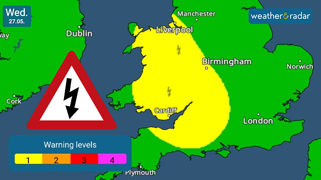
eather warning map of Wales and western England on Wednesday 27.05 showing a yellow thunderstorm alert area with lightning symbols, alongside a warning triangle and color-coded alert scale.
Thunderstorm warnings for Wednesday.

Tuesday saw the first larger outbreak of summery thunderstorms across central England. On Wednesday, the area to pay attention too is across Wales and western England.

Low-level warnings for thunder and lightning cover much of Wales, inching across Liverpool and down through the West Midlands into Somerset.

If these storms do develop, they would likely remain scattered but potentially potent with heavy rain in tow too as they form later in the day.

Aside from the thunderstorms, it's noticeably cooler today across much of the UK with temperatures dropping by up to 10 degrees for some.

It's still very hot in the south-west through where highs remain around the 30 °C mark in Bristol and Cardiff. Along the coast cool air helps quell the warmth.

Keep an eye on the WeatherRadar today to see any thunderstorms bubbling up, and when they do, switch to the LightningRadar to track strikes in near-real-time.

Ryan Hathaway
More on the topic
Cheshire Gap produces shower funnel. Local phenomenon. . . Wednesday, 9 September 2026
Weather map showing showers moving southeast from Liverpool toward Birmingham, driven by Cheshire Gap convergence across central England.
Wednesday, 9 September 2026

Local phenomenon

Cheshire Gap produces shower funnel
Hurricane Lowell threatens Hawaii. Gales and flash floods. . . Tuesday, 8 September 2026
WindRadar showing Hurricane Lowell north-west of Hawaii and its well-defined storm centre.
Tuesday, 8 September 2026

Gales and flash floods

Hurricane Lowell threatens Hawaii
Severe weather in southern Europe. Thunderstorms & heavy rain. . . Wednesday, 9 September 2026
On the left, dark storm clouds over a coastline. On the right, a weather map shows thunderstorms over the western Mediterranean, with warning symbols for tornadoes, storms and hail.
Wednesday, 9 September 2026

Thunderstorms & heavy rain

Severe weather in southern Europe
All weather news
This might also interest you
A stormy week in the skies above. Your weather - Your shots. . . Sunday, 30 August 2026
Split image showing lightning branching beneath dark storm clouds above rooftops on the left and an orange-pink sunset over a calm sea on the right.
Sunday, 30 August 2026

Your weather - Your shots

A stormy week in the skies above
New records for England and Wales. Broken again tomorrow?. . . Thursday, 25 June 2026
Temperature map of southwest Britain on 25.06 showing extreme heat across southern Wales and southwest England, with Bute Park in Cardiff highlighted at 34.2°C and Yeovilton at 36.4°C amid widespread deep red heat zones.
Thursday, 25 June 2026

Broken again tomorrow?

New records for England and Wales
A frozen start to the weekend. Icy conditions. . . Friday, 13 February 2026
UK temperature map dated 14.02 showing widespread subzero values in blue shading, with readings such as −4 in Glasgow, −3 in Dublin, and −2 in London, alongside a blue thermometer icon.
Friday, 13 February 2026

Icy conditions

A frozen start to the weekend
All articles
Weather & Radar

Weather & Radar is also available on

Google Play StoreApp Store

Company

Contact us Privacy Policy Legal info Accessibility statement

Services

Uploader

Socials

facebooktwittertikToklinkList