Home
Weather London
WeatherRadar
RainfallRadar
TemperatureRadar
WindRadar
LightningRadar
Weather News
Editor's Pick
Discover the app
Weather widget
Contact us
Apps
Career
    Home / Editor's Pick /

    Volcanic halo: luminous rings rise above Mount Etna

11:00
3 August 2023

Volcanic halo
Luminous rings rise above Mount Etna

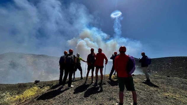
Smoke rings form over Mt Etna
Smoke ring
People watch volcanic smoke rings
Smoke ring
1/4
Smoke rings form over Etna - © Etna vulcano attivo più alto d'Europa

Bright shimmering rings rose above Mount Etna on Monday, not a sign of an eruption but another phenomenon entirely.

Mount Etna, Europe's largest active volcano, sent large halos into the sky earlier this week. These rings, which consist of water vapour, are not threatening, but they are rarely observed.

It is not clear exactly how these rings, which can reach over 600 feet wide, form. We do know that they require a circular vent with a similar height on all sides.

It is likely that the rings form when gas bubbles are impulsively forced through the narrow vent. In the process, they come under extreme pressure, explode and push the hot steam upwards.

At the same time, steam rolls up at the edge of the vent. When the rolled-up steam ring meets the cold atmosphere, the steam condenses and becomes visible, similarly to condensation trails.

Spotting this event is quite rare, but is not uncommon. Visitors to the site witnessed similar rings in May 2022.

Privacy Policy

Most of the time, the rings are twisted by the wind and destroyed again a short time after forming.

Etna is considered one of the most active volcanoes in the world, regularly releasing lava and ash onto the island of Sicily it calls home.

The volcano is so active that in 2021 so much volcanic material was expelled that the volcano actually grew by around 100 ft.

Ryan Hathaway
More on the topic
Icy spells in the Southern Hemisphere. Snow in the Andes. . . Tuesday, 28 July 2026
A composite image showing a temperature radar map of South America and a snow-covered town in Chile. The winter cold is bringing heavy snowfall to the Andes and, in some areas, snow down to lower altitudes.
Tuesday, 28 July 2026

Snow in the Andes

Icy spells in the Southern Hemisphere
Clouds return to capture the scene. Your weather - Your shots. . . Sunday, 26 July 2026
Waxing crescent Moon above vivid pink and magenta sunset clouds, with silhouetted trees along the horizon beneath a deepening blue twilight sky.
Sunday, 26 July 2026

Your weather - Your shots

Clouds return to capture the scene
Heavier rainfall over the week for some. Ireland & Scotland. . . Tuesday, 28 July 2026
Split image showing a Europe rainfall accumulation forecast map on the left with the highest totals across the UK, Ireland, and Scandinavia, and a satellite weather map on the right with a broad band of rain stretching across Ireland, Scotland, and northern Britain, highlighted by a rain cloud icon.
Tuesday, 28 July 2026

Ireland & Scotland

Heavier rainfall over the week for some
All weather news
This might also interest you
Super Typhoon Bavi threatens Taiwan. Up to 1,000 mm of rain. . . Wednesday, 8 July 2026
The image shows an intense tropical cyclone over the western Pacific, east of Taiwan and the Philippines. The centre of the system is depicted as a light purple and white vortex with a clearly visible eye, surrounded by a ring of red and orange areas indicating the strongest wind speeds. A white arrow marks the typhoon’s predicted track towards the north-west, in the direction of Taiwan. To the west of the storm lie the Philippines, with the cities of Manila and Cebu; to the north of these lies Taiwan, with Taipei. Further west, the Chinese coast, including Hong Kong, and parts of Vietnam can be seen. The coloured wind map shows predominantly green areas outside the storm’s core, indicating significantly weaker winds. White streamlines illustrate the typhoon’s anti-clockwise circulation in the Northern Hemisphere. The highest wind speeds are concentrated around the eye of the cyclone.
Wednesday, 8 July 2026

Up to 1,000 mm of rain

Super Typhoon Bavi threatens Taiwan
Turbulent weather in the Canary Islands. Storm and rain. . . Friday, 12 December 2025
Weather graphic showing rain and wind fields over the Canary Islands and a central warning symbol.
Friday, 12 December 2025

Storm and rain

Turbulent weather in the Canary Islands
A frozen start to the weekend. Icy conditions. . . Friday, 13 February 2026
UK temperature map dated 14.02 showing widespread subzero values in blue shading, with readings such as −4 in Glasgow, −3 in Dublin, and −2 in London, alongside a blue thermometer icon.
Friday, 13 February 2026

Icy conditions

A frozen start to the weekend
All articles
Weather & Radar

Weather & Radar is also available on

Google Play StoreApp Store

Company

Contact us Privacy Policy Legal info Accessibility statement

Services

Uploader

Socials

facebooktwittertikToklinkList