Home
Weather London
WeatherRadar
RainfallRadar
TemperatureRadar
WindRadar
LightningRadar
Weather News
Editor's Pick
Discover the app
Weather widget
Contact us
Apps
Career
    Home / Editor's Pick /

    Villages threatened again: New volcanic eruption in Iceland

15:30
17 March 2024

Villages threatened again
New volcanic eruption in Iceland

Helicopter footages shows the scene on Saturday evening.

A fresh volcanic eruption began in Iceland on Saturday evening with little warning, again threatening previously evacuated areas.

On Saturday evening at 20:33 (local time), lava erupted from a fissure in the earth in the same region of Iceland for the fourth time since December.

The bright eruptions near the coastal town of Grindavík could be seen from the capital Reykjavík, just 40 kilometres to the north-east.

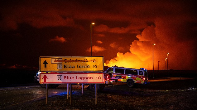
Emergency services on road leading to volcanic eruption
Emergency services remain nearby the scene, no access to the eruption site is currently allowed. - © picture alliance

All neighbouring villages were evacuated. Lava is partially flowing towards the protective barriers for the coastal town of Grindavík, which was already evacuated in November, and is now only around 200 metres away from them.

According to initial analyses of aerial photographs, it is assumed that the eruption is the strongest to date. It was preceded by only around 40 minutes of seismic activity before fountains of lava shot out of a fissure in the earth.

Iceland currently hosts 33 active volcanoes, the country is particularly ripe for volcanoes to form due to its location straddling the meeting of tectonic plates at the Mid-Atlantic Ridge.

December: The first eruptionread more
Weather & Radar editorial team
More on the topic
First taste of winter in the Alps. White mountain peaks. . . Friday, 25 September 2026
Winter scenery in the Alps along the Großglockner High Alpine Road
Friday, 25 September 2026

White mountain peaks

First taste of winter in the Alps
Hurricane threat off the coast of Mexico. Storm and rain. . . Monday, 21 September 2026
Split image showing a powerful tropical system southwest of Acapulco on a wind map and palm trees bending sharply in strong winds.
Monday, 21 September 2026

Storm and rain

Hurricane threat off the coast of Mexico
Europe split in two distinct patterns. Autumn meets summer. . . Tuesday, 22 September 2026
Weather maps show a storm over the North Atlantic and temperatures of up to 37 degrees in Spain and Portugal.
Tuesday, 22 September 2026

Autumn meets summer

Europe split in two distinct patterns
All weather news
This might also interest you
A stormy week in the skies above. Your weather - Your shots. . . Sunday, 30 August 2026
Split image showing lightning branching beneath dark storm clouds above rooftops on the left and an orange-pink sunset over a calm sea on the right.
Sunday, 30 August 2026

Your weather - Your shots

A stormy week in the skies above
Super Typhoon Bavi threatens Taiwan. Up to 1,000 mm of rain. . . Wednesday, 8 July 2026
The image shows an intense tropical cyclone over the western Pacific, east of Taiwan and the Philippines. The centre of the system is depicted as a light purple and white vortex with a clearly visible eye, surrounded by a ring of red and orange areas indicating the strongest wind speeds. A white arrow marks the typhoon’s predicted track towards the north-west, in the direction of Taiwan. To the west of the storm lie the Philippines, with the cities of Manila and Cebu; to the north of these lies Taiwan, with Taipei. Further west, the Chinese coast, including Hong Kong, and parts of Vietnam can be seen. The coloured wind map shows predominantly green areas outside the storm’s core, indicating significantly weaker winds. White streamlines illustrate the typhoon’s anti-clockwise circulation in the Northern Hemisphere. The highest wind speeds are concentrated around the eye of the cyclone.
Wednesday, 8 July 2026

Up to 1,000 mm of rain

Super Typhoon Bavi threatens Taiwan
Historic Storm Éowyn arrives. On this day.... . . Saturday, 24 January 2026
Split image showing a person in a yellow jacket struggling against strong winds and heavy rain on a street at night on the left, and an Irish wind forecast map on the right with red and purple shading, gusts up to 75 mph, and a wind warning icon, divided by a curved white line.
Saturday, 24 January 2026

On this day...

Historic Storm Éowyn arrives
All articles
Weather & Radar

Weather & Radar is also available on

Google Play StoreApp Store

Company

Contact us Privacy Policy Legal info Accessibility statement

Services

Uploader

Socials

facebooktwittertikToklinkList