Home
Weather London
WeatherRadar
RainfallRadar
TemperatureRadar
WindRadar
LightningRadar
Weather News
Editor's Pick
Discover the app
Weather widget
Contact us
Apps
Career
    Home / Editor's Pick /

    Villages threatened again: New volcanic eruption in Iceland

15:30
17 March 2024

Villages threatened again
New volcanic eruption in Iceland

Helicopter footages shows the scene on Saturday evening.

A fresh volcanic eruption began in Iceland on Saturday evening with little warning, again threatening previously evacuated areas.

On Saturday evening at 20:33 (local time), lava erupted from a fissure in the earth in the same region of Iceland for the fourth time since December.

The bright eruptions near the coastal town of Grindavík could be seen from the capital Reykjavík, just 40 kilometres to the north-east.

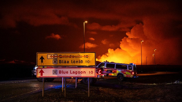
Emergency services on road leading to volcanic eruption
Emergency services remain nearby the scene, no access to the eruption site is currently allowed. - © picture alliance

All neighbouring villages were evacuated. Lava is partially flowing towards the protective barriers for the coastal town of Grindavík, which was already evacuated in November, and is now only around 200 metres away from them.

According to initial analyses of aerial photographs, it is assumed that the eruption is the strongest to date. It was preceded by only around 40 minutes of seismic activity before fountains of lava shot out of a fissure in the earth.

Iceland currently hosts 33 active volcanoes, the country is particularly ripe for volcanoes to form due to its location straddling the meeting of tectonic plates at the Mid-Atlantic Ridge.

December: The first eruptionread more
Weather & Radar editorial team

More on the topic

Preparing for the storms. What to do now. . . Thursday, 22 October 2026
Split image showing Storm Austen winds up to 65 mph near Brest and 55 mph near Plymouth, alongside fallen tree branches on a cordoned-off park path.
Thursday, 22 October 2026

What to do now

Preparing for the storms
Severe flooding in the south of France. Roads become rivers. . . Wednesday, 21 October 2026
Weather radar shows heavy rainfall over southern France, northern Italy, Corsica and Sardinia. A warning symbol indicates a risk of flooding.
Wednesday, 21 October 2026

Roads become rivers

Severe flooding in the south of France
Shooting stars from the Orionids peak. Mixed visibility overnight. . . Wednesday, 21 October 2026
Split image showing a bright green meteor streaking across a starry night sky beside a UK weather map with rain over Scotland and southern England.
Wednesday, 21 October 2026

Mixed visibility overnight

Shooting stars from the Orionids peak
All weather news

This might also interest you

A frozen start to the weekend. Icy conditions. . . Friday, 13 February 2026
UK temperature map dated 14.02 showing widespread subzero values in blue shading, with readings such as −4 in Glasgow, −3 in Dublin, and −2 in London, alongside a blue thermometer icon.
Friday, 13 February 2026

Icy conditions

A frozen start to the weekend
Storm Chandra makes impact. Severe gales & heavy rain. . . Tuesday, 27 January 2026
Split image showing strong winds over the UK on a forecast map and widespread rain and snow on a weather radar map.
Tuesday, 27 January 2026

Severe gales & heavy rain

Storm Chandra makes impact
Super Typhoon Bavi threatens Taiwan. Up to 1,000 mm of rain. . . Wednesday, 8 July 2026
The image shows an intense tropical cyclone over the western Pacific, east of Taiwan and the Philippines. The centre of the system is depicted as a light purple and white vortex with a clearly visible eye, surrounded by a ring of red and orange areas indicating the strongest wind speeds. A white arrow marks the typhoon’s predicted track towards the north-west, in the direction of Taiwan. To the west of the storm lie the Philippines, with the cities of Manila and Cebu; to the north of these lies Taiwan, with Taipei. Further west, the Chinese coast, including Hong Kong, and parts of Vietnam can be seen. The coloured wind map shows predominantly green areas outside the storm’s core, indicating significantly weaker winds. White streamlines illustrate the typhoon’s anti-clockwise circulation in the Northern Hemisphere. The highest wind speeds are concentrated around the eye of the cyclone.
Wednesday, 8 July 2026

Up to 1,000 mm of rain

Super Typhoon Bavi threatens Taiwan
All articles
Weather & Radar

Weather & Radar is also available on

Google Play StoreApp Store

Company

Contact us Privacy Policy Legal info Accessibility statement

Services

Uploader

Socials

facebooktwittertikToklinkList