Home
Weather London
WeatherRadar
RainfallRadar
TemperatureRadar
WindRadar
LightningRadar
Weather News
Editor's Pick
Discover the app
Weather widget
Contact us
Apps
Career
    Home / Editor's Pick /

    Vibrant skies, blood rain - Saharan dust reaches the UK

08:54
4 March 2026

Vibrant skies, blood rain
Saharan dust reaches the UK

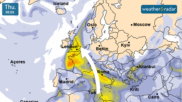
Aerosol density map dated Thu 05.03 showing a plume of Saharan dust in yellow and orange extending from North Africa across Spain and France into the UK, with an arrow indicating northward movement toward London.
Saharan dust reaches the UK by Thursday evening.

The skies will turn golden at sunrise and sunset to end the week, thanks to a plume of Saharan dust reaching the UK.

Earlier this week, the plume of dust, comprised of sand and mineral particles, moved over the Iberian Peninsula. From Thursday, it reaches our shores.

The largest concenration of dust in the atmosphere will pass over southern England, though there may be more colourful skies further north too.

Expect hazy skies, with the dust particles causing golden orange colours as the sun rises and sets. Additionally, should rain move in, a phenomenon known as blood rain is possible.

Rain washes the dust from the atmosphere, and can leave a dusty coating on vehicles as it falls. Patchy rain is expected overnight from Thursday into Friday.

Saharan dust reaching the UK is not particularly rare, and plumes can also cross the Atlantic Ocean into the Americas and Caribbean.

Learn more about blood rain!

Ryan Hathaway
More on the topic
Icy spells in the Southern Hemisphere. Snow in the Andes. . . Tuesday, 28 July 2026
A composite image showing a temperature radar map of South America and a snow-covered town in Chile. The winter cold is bringing heavy snowfall to the Andes and, in some areas, snow down to lower altitudes.
Tuesday, 28 July 2026

Snow in the Andes

Icy spells in the Southern Hemisphere
Fourth heatwave of the year. Peaking Wednesday. . . Tuesday, 28 July 2026
Temperature map of England and Wales on Wednesday 29.07 showing widespread hot conditions, with temperatures reaching 33°C near Cambridge, 32°C around London, Norwich, and Southend-on-Sea, and a large heat warning symbol highlighting elevated heat risk.
Tuesday, 28 July 2026

Peaking Wednesday

Fourth heatwave of the year
Clouds return to capture the scene. Your weather - Your shots. . . Sunday, 26 July 2026
Waxing crescent Moon above vivid pink and magenta sunset clouds, with silhouetted trees along the horizon beneath a deepening blue twilight sky.
Sunday, 26 July 2026

Your weather - Your shots

Clouds return to capture the scene
All weather news
This might also interest you
Flooding, gales, and heavy snow. Storm Chandra. . . Tuesday, 27 January 2026
Split image showing aerial flooding in a town with muddy water covering roads on the left, and a rural road on the right blocked by heavy snowfall with vans stopped and a person walking in snow.
Tuesday, 27 January 2026

Storm Chandra

Flooding, gales, and heavy snow
Storm Chandra makes impact. Severe gales & heavy rain. . . Tuesday, 27 January 2026
Split image showing strong winds over the UK on a forecast map and widespread rain and snow on a weather radar map.
Tuesday, 27 January 2026

Severe gales & heavy rain

Storm Chandra makes impact
Long-term trends need a pinch of salt. 40 °C in July?. . . Tuesday, 30 June 2026
Temperature radar of 2022 heatwave where the all-time temperature record in the UK was set. Warning symbol overlain.
Tuesday, 30 June 2026

40 °C in July?

Long-term trends need a pinch of salt
All articles
Weather & Radar

Weather & Radar is also available on

Google Play StoreApp Store

Company

Contact us Privacy Policy Legal info Accessibility statement

Services

Uploader

Socials

facebooktwittertikToklinkList