Home
Weather London
WeatherRadar
RainfallRadar
TemperatureRadar
WindRadar
LightningRadar
Weather News
Editor's Pick
Discover the app
Weather widget
Contact us
Apps
Career
    Home / Editor's Pick /

    USA cut in two - Temperature split of almost 50 degrees

11:00
13 March 2026

USA cut in two
Temperature difference of almost 50 degrees

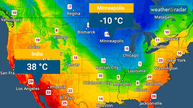
TemperatureRadar forecast for Monday

In the USA, icy cold winter air meets hot summer air. This results in enormous temperature contrasts.

These will be particularly pronounced at the beginning of next week, when Arizona and California will already be experiencing summer heat. In Indio in the Colorado Desert, for example, temperatures of around 40 degrees are expected.

At the same time, polar air is flowing in from the north, causing temperatures to drop to minus 10 degrees in North Dakota and Minnesota, among other states . At night , it is even minus 20 degrees. In some cities, such as Memphis, the temperature drops by 20 degrees from one day to the next.

Memphis

We
26
33
Th
23
34
Fr
23
34
Sa
25
29
Su
21
26
Mo
22
30
Tu
22
32
We
24
34
Th
25
36
Fr
26
38
Sa
24
38
Su
24
37
Mo
25
37
Tu
26
37
Max (°C)
Min (°C)
moreless

Phoenix

We
32
43
Th
33
45
Fr
33
46
Sa
35
46
Su
35
45
Mo
33
43
Tu
33
43
We
32
42
Th
29
39
Fr
28
37
Sa
30
38
Su
29
39
Mo
30
40
Tu
31
40
Max (°C)
Min (°C)
moreless

Minneapolis

We
22
34
Th
24
32
Fr
21
23
Sa
19
29
Su
19
29
Mo
20
29
Tu
22
30
We
21
33
Th
20
33
Fr
20
30
Sa
21
31
Su
19
33
Mo
23
33
Tu
25
37
Max (°C)
Min (°C)
moreless

At the beginning of next week, severe thunderstorms with strong gusting winds and large hailstones will develop in the transition zone between the two air masses. A blizzard, an intense snowstorm, is also forecast in the cold air. There will be freezing rain in the transition zone.

Such weather contrasts are not unusual in the USA. Since there is no mountain range running from west to east, polar air can advance very far south unhindered. At the same time, North America has large land masses that warm up much faster than water.

Verena Leyendecker
More on the topic
Clouds return to capture the scene. Your weather - Your shots. . . Sunday, 26 July 2026
Waxing crescent Moon above vivid pink and magenta sunset clouds, with silhouetted trees along the horizon beneath a deepening blue twilight sky.
Sunday, 26 July 2026

Your weather - Your shots

Clouds return to capture the scene
Icy spells in the Southern Hemisphere. Snow in the Andes. . . Tuesday, 28 July 2026
A composite image showing a temperature radar map of South America and a snow-covered town in Chile. The winter cold is bringing heavy snowfall to the Andes and, in some areas, snow down to lower altitudes.
Tuesday, 28 July 2026

Snow in the Andes

Icy spells in the Southern Hemisphere
Rain returns to end dry spell in places. Jet stream delivery. . . Thursday, 23 July 2026
Split weather graphic showing widespread showers across the UK and Ireland on the left, and a wind forecast map on the right with a windsock icon and gusts of 25 to 35 mph, highlighting breezy conditions across the two countries.
Thursday, 23 July 2026

Jet stream delivery

Rain returns to end dry spell in places
All weather news
This might also interest you
Super Typhoon Bavi threatens Taiwan. Up to 1,000 mm of rain. . . Wednesday, 8 July 2026
The image shows an intense tropical cyclone over the western Pacific, east of Taiwan and the Philippines. The centre of the system is depicted as a light purple and white vortex with a clearly visible eye, surrounded by a ring of red and orange areas indicating the strongest wind speeds. A white arrow marks the typhoon’s predicted track towards the north-west, in the direction of Taiwan. To the west of the storm lie the Philippines, with the cities of Manila and Cebu; to the north of these lies Taiwan, with Taipei. Further west, the Chinese coast, including Hong Kong, and parts of Vietnam can be seen. The coloured wind map shows predominantly green areas outside the storm’s core, indicating significantly weaker winds. White streamlines illustrate the typhoon’s anti-clockwise circulation in the Northern Hemisphere. The highest wind speeds are concentrated around the eye of the cyclone.
Wednesday, 8 July 2026

Up to 1,000 mm of rain

Super Typhoon Bavi threatens Taiwan
Bright and warm conditions take hold. Spring-like outlook. . . Thursday, 23 April 2026
Split UK map showing warm temperatures up to 21 degrees in orange on the left and clear sunny conditions with temperatures from 12 to 18 degrees on the right, with sun icons across the country.
Thursday, 23 April 2026

Spring-like outlook

Bright and warm conditions take hold
New records for England and Wales. Broken again tomorrow?. . . Thursday, 25 June 2026
Temperature map of southwest Britain on 25.06 showing extreme heat across southern Wales and southwest England, with Bute Park in Cardiff highlighted at 34.2°C and Yeovilton at 36.4°C amid widespread deep red heat zones.
Thursday, 25 June 2026

Broken again tomorrow?

New records for England and Wales
All articles
Weather & Radar

Weather & Radar is also available on

Google Play StoreApp Store

Company

Contact us Privacy Policy Legal info Accessibility statement

Services

Uploader

Socials

facebooktwittertikToklinkList