Home
Weather London
WeatherRadar
RainfallRadar
TemperatureRadar
WindRadar
LightningRadar
Weather News
Editor's Pick
Discover the app
Weather widget
Contact us
Apps
Career
    Home / Editor's Pick /

    USA - Alone with the supercell - Storm chaser's Blog

14:45
16 July 2025

Storm chaser's Blog
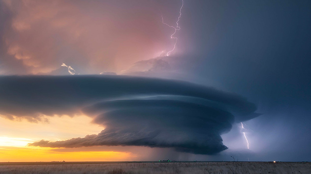
USA - Alone with the supercell

incredible supercell with lightning
© Dennis Oswald

Weather & Radar's meteorologist and photographer Dennis Oswald is our most experienced storm chaser. This is his personal account of his most breathtaking storm encounter.

“For more than 25 years, I have been on the lookout for the perfect thunderstorm with my camera. In May 2016, I experienced one of my personal highlights in the heart of Tornado Alley in the US state of Kansas.

We love weather!

Last year, in the miniseries 'Storm chaser's Blog', Weather & Radar's meteorologists shared their wildest experiences chasing storms. As avid photographers and storm chasers, their passion for weather is a lifestyle that reaches far beyond their work.

A huge supercell formed right in front of me and rotated for more than four hours without moving. I was able to observe and document its entire life cycle, including two tornadoes. As the day progressed, the light was constantly changing.

Although gale-force winds made photography difficult, the whole scene seemed almost peaceful to me.

Recommended external content from YouTube

We need your consent to show content from YouTube. You can withdraw your consent at any time.

I agree that content from YouTube will be displayed to me.
Privacy Policy

I like to compare my fascination for storms with the fascination for nature in general. As a storm chaser and weather photographer, I enjoy a thunderstorm just as much as a hiker enjoys a mountain panorama.

To me, thunderstorms are just as much a part of nature as everything else."

Beginners luck - the first tornadoread also

Every year since 2008, Dennis Oswald has travelled to Tornado Alley in the USA on storm chasing and photography trips. He also regularly travels to stormy hotspots in Europe, and has done so since 1998.

You can see his phenomenal photos on his Instagram account, and he is a regular contributor to Weather & Radar's news and social media channels.

Did you know that you can share your weather images with Weather & Radar with the uploader? Storm chaser or not, we love to see your beautiful or wild shots.

A tornado too close for comfortread more
Weather & Radar editorial team
More on the topic
Cooler nights on the horizon. For parts of Europe. . . Thursday, 6 August 2026
Temperature Radar showing the night-time lows in Central Europe. Cooler air is reaching the west and north in particular, whilst the south-east remains significantly warmer.
Thursday, 6 August 2026

For parts of Europe

Cooler nights on the horizon
Late season views as summer rolls on. Your weather - Your shots. . . Sunday, 9 August 2026
Split image showing a horseback ride along a green hillside trail beneath blue skies on the left and a small sailboat on a calm coastal bay under broken clouds on the right.
Sunday, 9 August 2026

Your weather - Your shots

Late season views as summer rolls on
Japan braces itself for Typhoon Dolphin. Landslides feared. . . Wednesday, 5 August 2026
Weather map showing a typhoon south of Japan. The centre of the storm is over the Pacific and is moving westwards. The coloured wind fields indicate its high intensity.
Wednesday, 5 August 2026

Landslides feared

Japan braces itself for Typhoon Dolphin
All weather news
This might also interest you
Flooding, gales, and heavy snow. Storm Chandra. . . Tuesday, 27 January 2026
Split image showing aerial flooding in a town with muddy water covering roads on the left, and a rural road on the right blocked by heavy snowfall with vans stopped and a person walking in snow.
Tuesday, 27 January 2026

Storm Chandra

Flooding, gales, and heavy snow
Seasonal warmth between spring thunder. Your weather - Your shots. . . Sunday, 19 April 2026
Split image showing coastal sunset with layered lenticular clouds over rooftops and palm trees on the left, and a green valley with river and hills under soft daylight on the right.
Sunday, 19 April 2026

Your weather - Your shots

Seasonal warmth between spring thunder
Super Typhoon Bavi threatens Taiwan. Up to 1,000 mm of rain. . . Wednesday, 8 July 2026
The image shows an intense tropical cyclone over the western Pacific, east of Taiwan and the Philippines. The centre of the system is depicted as a light purple and white vortex with a clearly visible eye, surrounded by a ring of red and orange areas indicating the strongest wind speeds. A white arrow marks the typhoon’s predicted track towards the north-west, in the direction of Taiwan. To the west of the storm lie the Philippines, with the cities of Manila and Cebu; to the north of these lies Taiwan, with Taipei. Further west, the Chinese coast, including Hong Kong, and parts of Vietnam can be seen. The coloured wind map shows predominantly green areas outside the storm’s core, indicating significantly weaker winds. White streamlines illustrate the typhoon’s anti-clockwise circulation in the Northern Hemisphere. The highest wind speeds are concentrated around the eye of the cyclone.
Wednesday, 8 July 2026

Up to 1,000 mm of rain

Super Typhoon Bavi threatens Taiwan
All articles
Weather & Radar

Weather & Radar is also available on

Google Play StoreApp Store

Company

Contact us Privacy Policy Legal info Accessibility statement

Services

Uploader

Socials

facebooktwittertikToklinkList