Home
Weather London
WeatherRadar
RainfallRadar
TemperatureRadar
WindRadar
LightningRadar
Weather News
Editor's Pick
Discover the app
Weather widget
Contact us
Apps
Career
    Home / Editor's Pick /

    US East Coast: Blizzard paralyses cities

14:00
24 February 2026

Snowstorm fallout
US East Coast: Blizzard paralyses cities

A violent winter storm has swept across the north-east of the United States, bringing life to a standstill for millions of people.

Hundreds of thousands of households are without power, around 500,000 of them along the east coast. In Massachusetts alone, around 280,000 people have been affected.

The state of emergency was extended in some regions. Transport also came to a virtual standstill. Around 4,700 flights were cancelled at airports in New York and New Jersey.

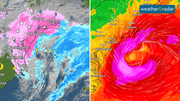
Left: heavy snowfall on the US East Coast on Monday. Right: wind gusts – the redder the colours, the stronger the wind.

Bus services were limited, and at times there was a driving ban. Schools and libraries remained closed. Falling trees tore down power lines, and there was flooding along the coast.

Did you know?

A blizzard is a severe snowstorm with wind speeds exceeding 35 miles per hour and severely restricted visibility. It can temporarily bring public life to a standstill. 

Up to one metre of snow fell in Rhode Island, more than 80 centimetres in Massachusetts and around 50 centimetres in New York.

Sebastian Keßler
with material from dpa
More on the topic
Late season views as summer rolls on. Your weather - Your shots. . . Sunday, 9 August 2026
Split image showing a horseback ride along a green hillside trail beneath blue skies on the left and a small sailboat on a calm coastal bay under broken clouds on the right.
Sunday, 9 August 2026

Your weather - Your shots

Late season views as summer rolls on
The solar eclipse arrives tonight. Great visibility for most. . . Wednesday, 12 August 2026
Split image showing an annular solar eclipse on the left and a UK and Ireland weather map on the right with mostly sunny skies, temperatures of 30–31°C in England and 27°C in Dublin.
Wednesday, 12 August 2026

Great visibility for most

The solar eclipse arrives tonight
Huge hailstones in Poland. Severe weather hits towns. . . Friday, 7 August 2026
Friday, 7 August 2026

Severe weather hits towns

Huge hailstones in Poland
All weather news
This might also interest you
New records for England and Wales. Broken again tomorrow?. . . Thursday, 25 June 2026
Temperature map of southwest Britain on 25.06 showing extreme heat across southern Wales and southwest England, with Bute Park in Cardiff highlighted at 34.2°C and Yeovilton at 36.4°C amid widespread deep red heat zones.
Thursday, 25 June 2026

Broken again tomorrow?

New records for England and Wales
Super Typhoon Bavi threatens Taiwan. Up to 1,000 mm of rain. . . Wednesday, 8 July 2026
The image shows an intense tropical cyclone over the western Pacific, east of Taiwan and the Philippines. The centre of the system is depicted as a light purple and white vortex with a clearly visible eye, surrounded by a ring of red and orange areas indicating the strongest wind speeds. A white arrow marks the typhoon’s predicted track towards the north-west, in the direction of Taiwan. To the west of the storm lie the Philippines, with the cities of Manila and Cebu; to the north of these lies Taiwan, with Taipei. Further west, the Chinese coast, including Hong Kong, and parts of Vietnam can be seen. The coloured wind map shows predominantly green areas outside the storm’s core, indicating significantly weaker winds. White streamlines illustrate the typhoon’s anti-clockwise circulation in the Northern Hemisphere. The highest wind speeds are concentrated around the eye of the cyclone.
Wednesday, 8 July 2026

Up to 1,000 mm of rain

Super Typhoon Bavi threatens Taiwan
Historic Storm Éowyn arrives. On this day.... . . Saturday, 24 January 2026
Split image showing a person in a yellow jacket struggling against strong winds and heavy rain on a street at night on the left, and an Irish wind forecast map on the right with red and purple shading, gusts up to 75 mph, and a wind warning icon, divided by a curved white line.
Saturday, 24 January 2026

On this day...

Historic Storm Éowyn arrives
All articles
Weather & Radar

Weather & Radar is also available on

Google Play StoreApp Store

Company

Contact us Privacy Policy Legal info Accessibility statement

Services

Uploader

Socials

facebooktwittertikToklinkList