Home
Weather London
WeatherRadar
RainfallRadar
TemperatureRadar
WindRadar
LightningRadar
Weather News
Editor's Pick
Discover the app
Weather widget
Contact us
Apps
Career
    Home / Editor's Pick /

    Until the weekend - Heat warning cover much of Ireland

09:30
16 July 2026

Until the weekend
Heat warnings cover much of Ireland

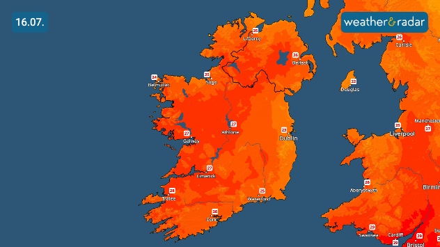
Temperature map of Ireland on 16.07 showing warm to hot conditions nationwide, with temperatures ranging from 23°C in Dublin and Galway to 28°C in Tralee, 27°C in Athlone and Limerick, and 26°C in Cork and Belfast.
Daily highs for Thursday grow warmer away from the east coast.

Grab the sun cream and prepare for more hot days across Ireland with high temperature warnings stretching across much of the country to end the week.

With maximum temperatures over 27°C and overnight minimum temperatures over 15°C, yellow warnings cover much of the Emerald Isle with just Dublin, Wicklow, Meath, Louth, and Monaghan escaping.

All other counties fall under the warnings which began on Wednesday and run into Friday morning. A second warning then goes live from Friday midday for daytime highs of over 27°C in the same areas.

The TemperatureRadar shows that the hottest areas of the country will lay to the south-west, reaching around 28°C in Tralee. Though wide swathes of western to central areas will see highs just a degree lower.

Meanwhile northeasterly winds keep the east coast a little cooler. A high of 23°C is expected for Dublin and Wicklow.

Keep an eye on temperatures as they rise, and eventually fall, on the TemperatureRadar for any area.

Ryan Hathaway

More on the topic

Gloomy evening with a few spots of rain. Bonfire Night. . . Thursday, 5 November 2026
Split image showing a cloudy UK weather map with temperatures of 8–9°C alongside colourful fireworks bursting through smoke in the night sky.
Thursday, 5 November 2026

Bonfire Night

Gloomy evening with a few spots of rain
Further fog disruption expected. Growing dense overnight. . . Monday, 9 November 2026
Weather map showing widespread fog across the English Midlands, with a red fog warning symbol near Nottingham and temperatures of 4–6°C.
Monday, 9 November 2026

Growing dense overnight

Further fog disruption expected
Conditions combine to reduce air quality. Light winds and fireworks. . . Tuesday, 10 November 2026
Split image showing a UK wind map with 25 mph near Cardiff and 19 mph near London, beside colourful fireworks above illuminated waterfront buildings.
Tuesday, 10 November 2026

Light winds and fireworks

Conditions combine to reduce air quality
All weather news

This might also interest you

Historic Storm Éowyn arrives. On this day.... . . Saturday, 24 January 2026
Split image showing a person in a yellow jacket struggling against strong winds and heavy rain on a street at night on the left, and an Irish wind forecast map on the right with red and purple shading, gusts up to 75 mph, and a wind warning icon, divided by a curved white line.
Saturday, 24 January 2026

On this day...

Historic Storm Éowyn arrives
Long-term trends need a pinch of salt. 40 °C in July?. . . Tuesday, 30 June 2026
Temperature radar of 2022 heatwave where the all-time temperature record in the UK was set. Warning symbol overlain.
Tuesday, 30 June 2026

40 °C in July?

Long-term trends need a pinch of salt
New records for England and Wales. Broken again tomorrow?. . . Thursday, 25 June 2026
Temperature map of southwest Britain on 25.06 showing extreme heat across southern Wales and southwest England, with Bute Park in Cardiff highlighted at 34.2°C and Yeovilton at 36.4°C amid widespread deep red heat zones.
Thursday, 25 June 2026

Broken again tomorrow?

New records for England and Wales
All articles
Weather & Radar

Weather & Radar is also available on

Google Play StoreApp Store

Company

Contact us Privacy Policy Legal info Accessibility statement

Services

Uploader

Socials

facebooktwittertikToklinkList