Home
Weather London
WeatherRadar
RainfallRadar
TemperatureRadar
WindRadar
LightningRadar
Weather News
Editor's Pick
Discover the app
Weather widget
Contact us
Apps
Career
    Home / Editor's Pick /

    Unsettled midweek - Wet & windy Wednesday for some

16:00
31 March 2026

Unsettled midweek
Wet & windy Wednesday for some

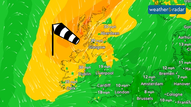
Wind forecast map showing moderate winds across the UK and Ireland, with gusts around 30 mph in Scotland and Ireland and lighter winds further south, plus a windsock icon.
Ireland and northern UK sees a gusty midweek.

Wednesday remains somewhat mild broadly, but not across Ireland and Scotland where stronger winds will return alongside a band of rain moving through.

Calmer winds prevailed on Tuesday across the country, but from Wednesday afternoon a fresh pressure system is renewing gusts.

This is felt from the early morning, gusts of up to 40 mph will greet parts of western Scotland to begin th day, before spreading across Ireland and down into northern England too.

Joining the growing winds, light rain stretches across the UK in the morning, before a heavier belt moves through. First reaching Ireland and western Scotland from around 09:00 am as it moves southeast through England, dissipating in the Midlands.

This rain has a good chance of turning wintry over the altitude of Scotland's Highlands, but snow is unlikely to become more widespread.

Clearer skies prevail behind the band of rainfall, providing a sunnier end to the day across Ireland, Northern Ireland, and western Scotland as the band loses momentum in the evening.

Ryan Hathaway

More on the topic

Front brings showers from the south-west. Brolly needed for some. . . Tuesday, 10 November 2026
Weather map showing blue rain bands across southern Ireland, Wales and southwest England, with a northeastward arrow and temperatures of 7–10°C.
Tuesday, 10 November 2026

Brolly needed for some

Front brings showers from the south-west
Further fog disruption expected. Growing dense overnight. . . Monday, 9 November 2026
Weather map showing widespread fog across the English Midlands, with a red fog warning symbol near Nottingham and temperatures of 4–6°C.
Monday, 9 November 2026

Growing dense overnight

Further fog disruption expected
Conditions combine to reduce air quality. Light winds and fireworks. . . Tuesday, 10 November 2026
Split image showing a UK wind map with 25 mph near Cardiff and 19 mph near London, beside colourful fireworks above illuminated waterfront buildings.
Tuesday, 10 November 2026

Light winds and fireworks

Conditions combine to reduce air quality
All weather news

This might also interest you

Flooding, gales, and heavy snow. Storm Chandra. . . Tuesday, 27 January 2026
Split image showing aerial flooding in a town with muddy water covering roads on the left, and a rural road on the right blocked by heavy snowfall with vans stopped and a person walking in snow.
Tuesday, 27 January 2026

Storm Chandra

Flooding, gales, and heavy snow
New records for England and Wales. Broken again tomorrow?. . . Thursday, 25 June 2026
Temperature map of southwest Britain on 25.06 showing extreme heat across southern Wales and southwest England, with Bute Park in Cardiff highlighted at 34.2°C and Yeovilton at 36.4°C amid widespread deep red heat zones.
Thursday, 25 June 2026

Broken again tomorrow?

New records for England and Wales
Seasonal warmth between spring thunder. Your weather - Your shots. . . Sunday, 19 April 2026
Split image showing coastal sunset with layered lenticular clouds over rooftops and palm trees on the left, and a green valley with river and hills under soft daylight on the right.
Sunday, 19 April 2026

Your weather - Your shots

Seasonal warmth between spring thunder
All articles
Weather & Radar

Weather & Radar is also available on

Google Play StoreApp Store

Company

Contact us Privacy Policy Legal info Accessibility statement

Services

Uploader

Socials

facebooktwittertikToklinkList