Home
Weather London
WeatherRadar
RainfallRadar
TemperatureRadar
WindRadar
LightningRadar
Weather News
Editor's Pick
Discover the app
Weather widget
Contact us
Apps
Career
    Home / Editor's Pick /

    Unsettled midweek - Wet & windy Wednesday for some

16:00
31 March 2026

Unsettled midweek
Wet & windy Wednesday for some

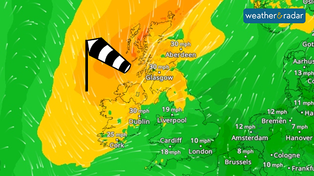
Wind forecast map showing moderate winds across the UK and Ireland, with gusts around 30 mph in Scotland and Ireland and lighter winds further south, plus a windsock icon.
Ireland and northern UK sees a gusty midweek.

Wednesday remains somewhat mild broadly, but not across Ireland and Scotland where stronger winds will return alongside a band of rain moving through.

Calmer winds prevailed on Tuesday across the country, but from Wednesday afternoon a fresh pressure system is renewing gusts.

This is felt from the early morning, gusts of up to 40 mph will greet parts of western Scotland to begin th day, before spreading across Ireland and down into northern England too.

Joining the growing winds, light rain stretches across the UK in the morning, before a heavier belt moves through. First reaching Ireland and western Scotland from around 09:00 am as it moves southeast through England, dissipating in the Midlands.

This rain has a good chance of turning wintry over the altitude of Scotland's Highlands, but snow is unlikely to become more widespread.

Clearer skies prevail behind the band of rainfall, providing a sunnier end to the day across Ireland, Northern Ireland, and western Scotland as the band loses momentum in the evening.

Ryan Hathaway

More on the topic

Shooting stars from the Orionids peak. Mixed visibility overnight. . . Wednesday, 21 October 2026
Split image showing a bright green meteor streaking across a starry night sky beside a UK weather map with rain over Scotland and southern England.
Wednesday, 21 October 2026

Mixed visibility overnight

Shooting stars from the Orionids peak
Storm Austen approaches. What to expect tonight. . . Thursday, 22 October 2026
Split image showing a wind map with 65 mph near Brest and a swirling storm south of England, beside a man wearing glasses and holding a microphone.
Thursday, 22 October 2026

What to expect tonight

Storm Austen approaches
Calmer autumn views on a stormy week. Your weather - Your shots. . . Sunday, 25 October 2026
Split image showing swirling orange-pink sunset clouds above green countryside and golden wispy clouds over a tree-lined car park.
Sunday, 25 October 2026

Your weather - Your shots

Calmer autumn views on a stormy week
All weather news

This might also interest you

Seasonal warmth between spring thunder. Your weather - Your shots. . . Sunday, 19 April 2026
Split image showing coastal sunset with layered lenticular clouds over rooftops and palm trees on the left, and a green valley with river and hills under soft daylight on the right.
Sunday, 19 April 2026

Your weather - Your shots

Seasonal warmth between spring thunder
Historic Storm Éowyn arrives. On this day.... . . Saturday, 24 January 2026
Split image showing a person in a yellow jacket struggling against strong winds and heavy rain on a street at night on the left, and an Irish wind forecast map on the right with red and purple shading, gusts up to 75 mph, and a wind warning icon, divided by a curved white line.
Saturday, 24 January 2026

On this day...

Historic Storm Éowyn arrives
A frozen start to the weekend. Icy conditions. . . Friday, 13 February 2026
UK temperature map dated 14.02 showing widespread subzero values in blue shading, with readings such as −4 in Glasgow, −3 in Dublin, and −2 in London, alongside a blue thermometer icon.
Friday, 13 February 2026

Icy conditions

A frozen start to the weekend
All articles
Weather & Radar

Weather & Radar is also available on

Google Play StoreApp Store

Company

Contact us Privacy Policy Legal info Accessibility statement

Services

Uploader

Socials

facebooktwittertikToklinkList