Home
Weather London
WeatherRadar
RainfallRadar
TemperatureRadar
WindRadar
LightningRadar
Weather News
Editor's Pick
Discover the app
Weather widget
Contact us
Apps
Career
    Home / Editor's Pick /

    Unsettled midweek - Wet & windy Wednesday for some

16:00
31 March 2026

Unsettled midweek
Wet & windy Wednesday for some

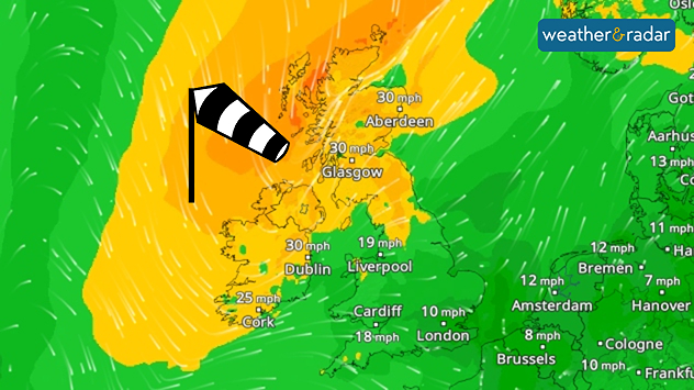
Wind forecast map showing moderate winds across the UK and Ireland, with gusts around 30 mph in Scotland and Ireland and lighter winds further south, plus a windsock icon.
Ireland and northern UK sees a gusty midweek.

Wednesday remains somewhat mild broadly, but not across Ireland and Scotland where stronger winds will return alongside a band of rain moving through.

Calmer winds prevailed on Tuesday across the country, but from Wednesday afternoon a fresh pressure system is renewing gusts.

This is felt from the early morning, gusts of up to 40 mph will greet parts of western Scotland to begin th day, before spreading across Ireland and down into northern England too.

Joining the growing winds, light rain stretches across the UK in the morning, before a heavier belt moves through. First reaching Ireland and western Scotland from around 09:00 am as it moves southeast through England, dissipating in the Midlands.

This rain has a good chance of turning wintry over the altitude of Scotland's Highlands, but snow is unlikely to become more widespread.

Clearer skies prevail behind the band of rainfall, providing a sunnier end to the day across Ireland, Northern Ireland, and western Scotland as the band loses momentum in the evening.

Ryan Hathaway
More on the topic
Clouds return to capture the scene. Your weather - Your shots. . . Sunday, 26 July 2026
Waxing crescent Moon above vivid pink and magenta sunset clouds, with silhouetted trees along the horizon beneath a deepening blue twilight sky.
Sunday, 26 July 2026

Your weather - Your shots

Clouds return to capture the scene
Catastrophic forest fires in Europe. Thousands evacuated. . . Monday, 27 July 2026
A composite image showing a temperature map of south-western Europe and a drone shot of a forest fire near Cap Ferret. A warning symbol featuring a flame indicates the increased risk of forest fires.
Monday, 27 July 2026

Thousands evacuated

Catastrophic forest fires in Europe
Fourth heatwave of the year. Peaking Wednesday. . . Tuesday, 28 July 2026
Temperature map of England and Wales on Wednesday 29.07 showing widespread hot conditions, with temperatures reaching 33°C near Cambridge, 32°C around London, Norwich, and Southend-on-Sea, and a large heat warning symbol highlighting elevated heat risk.
Tuesday, 28 July 2026

Peaking Wednesday

Fourth heatwave of the year
All weather news
This might also interest you
Turbulent weather in the Canary Islands. Storm and rain. . . Friday, 12 December 2025
Weather graphic showing rain and wind fields over the Canary Islands and a central warning symbol.
Friday, 12 December 2025

Storm and rain

Turbulent weather in the Canary Islands
Bright and warm conditions take hold. Spring-like outlook. . . Thursday, 23 April 2026
Split UK map showing warm temperatures up to 21 degrees in orange on the left and clear sunny conditions with temperatures from 12 to 18 degrees on the right, with sun icons across the country.
Thursday, 23 April 2026

Spring-like outlook

Bright and warm conditions take hold
Storm Chandra makes impact. Severe gales & heavy rain. . . Tuesday, 27 January 2026
Split image showing strong winds over the UK on a forecast map and widespread rain and snow on a weather radar map.
Tuesday, 27 January 2026

Severe gales & heavy rain

Storm Chandra makes impact
All articles
Weather & Radar

Weather & Radar is also available on

Google Play StoreApp Store

Company

Contact us Privacy Policy Legal info Accessibility statement

Services

Uploader

Socials

facebooktwittertikToklinkList