Home
Weather London
WeatherRadar
RainfallRadar
TemperatureRadar
WindRadar
LightningRadar
Weather News
Editor's Pick
Discover the app
Weather widget
Contact us
Apps
Career
    Home / Editor's Pick /

    Typhoon risk in the Western Pacific - Gusts exceeding 124 mph

10:00
28 May 2026

Gusts exceeding 124 mph
Typhoon risk in the Western Pacific

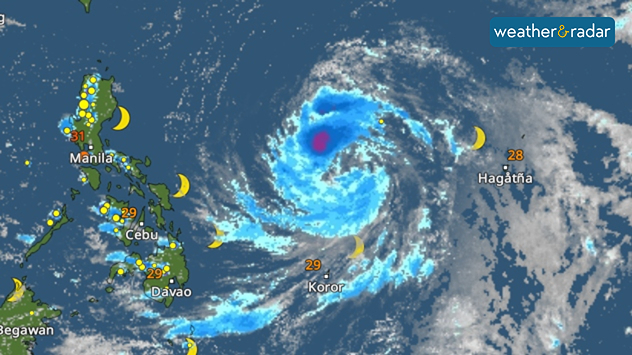
A tropical storm is currently forming in the western Pacific. The tropical depression, named Jangmi, is still moving across the open sea and is expected to develop into a powerful typhoon by Friday.

WeatherRadar: A tropical storm named Jangmi is currently circling east of the Philippines.

Wind speeds of over 123 miles per hour are even possible this weekend. Right now, Jangmi is currently still east of the Philippines and is slowly heading towards Japan.

By the start of next week, the typhoon could come dangerously close to Japan’s southernmost islands, the Ryukyu Islands. However, it is not yet entirely clear exactly where it will pass through.

In addition to gale-force winds, the main threats there are high waves and dangerous surf along the coast. There will also be heavy rain, which could cause flooding and landslides.

Weather & Radar editorial team
More on the topic
Solar eclipse on Wednesday. Save the date. . . Monday, 10 August 2026
People are watching a solar eclipse. The sun is already partially obscured. Next to it is the weather radar forecast for Wednesday, showing an almost cloudless sky.
Monday, 10 August 2026

Save the date

Solar eclipse on Wednesday
The solar eclipse arrives tonight. Great visibility for most. . . Wednesday, 12 August 2026
Split image showing an annular solar eclipse on the left and a UK and Ireland weather map on the right with mostly sunny skies, temperatures of 30–31°C in England and 27°C in Dublin.
Wednesday, 12 August 2026

Great visibility for most

The solar eclipse arrives tonight
Cooler nights on the horizon. For parts of Europe. . . Thursday, 6 August 2026
Temperature Radar showing the night-time lows in Central Europe. Cooler air is reaching the west and north in particular, whilst the south-east remains significantly warmer.
Thursday, 6 August 2026

For parts of Europe

Cooler nights on the horizon
All weather news
This might also interest you
Storm Chandra makes impact. Severe gales & heavy rain. . . Tuesday, 27 January 2026
Split image showing strong winds over the UK on a forecast map and widespread rain and snow on a weather radar map.
Tuesday, 27 January 2026

Severe gales & heavy rain

Storm Chandra makes impact
Turbulent weather in the Canary Islands. Storm and rain. . . Friday, 12 December 2025
Weather graphic showing rain and wind fields over the Canary Islands and a central warning symbol.
Friday, 12 December 2025

Storm and rain

Turbulent weather in the Canary Islands
New records for England and Wales. Broken again tomorrow?. . . Thursday, 25 June 2026
Temperature map of southwest Britain on 25.06 showing extreme heat across southern Wales and southwest England, with Bute Park in Cardiff highlighted at 34.2°C and Yeovilton at 36.4°C amid widespread deep red heat zones.
Thursday, 25 June 2026

Broken again tomorrow?

New records for England and Wales
All articles
Weather & Radar

Weather & Radar is also available on

Google Play StoreApp Store

Company

Contact us Privacy Policy Legal info Accessibility statement

Services

Uploader

Socials

facebooktwittertikToklinkList