Home
Weather London
WeatherRadar
RainfallRadar
TemperatureRadar
WindRadar
LightningRadar
Weather News
Editor's Pick
Discover the app
Weather widget
Contact us
Apps
Career
    Home / Editor's Pick /

    Two weather worlds in Europe: unevenly distributed rainfall

11:00
29 April 2026

Unevenly spread rainfall
Two weather worlds in Europe

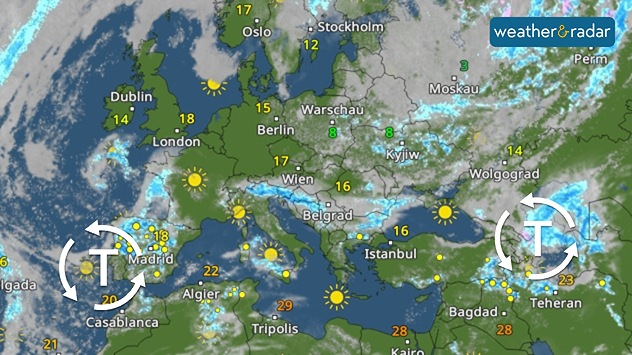
Unusual weather: Unlike usual, low-pressure systems are currently causing rather changeable weather in southern Europe, with showers and thunderstorms. Spain, southern Italy and Turkey are particularly affected.

The map shows the current general weather pattern. A high-pressure system over Central Europe is flanked by two low-pressure systems.

In contrast, in Central Europe a strong high-pressure system has been in control for several days now.

"Fine" weather has its downsides too

The prolonged spell of fine weather in Central Europe is becoming an increasing problem. The lack of rain is causing the ground to dry out, increasing the risk of forest fires and causing river levels to fall.

In some countries, such as Germany and Austria, several areas of woodland have already been affected by fires.

Did you know?

Plants need plenty of water to grow, especially in spring.

In southern European countries, the current rain is a blessing, as summers there are almost always very dry.

Will it rain again soon?

The general weather pattern is set to remain unchanged over the coming days. There will be no rain in many parts of Central Europe. The situation looks much better in Southern Europe:

It is only towards the weekend that the risk of showers and thunderstorms will increase in France, Belgium, Germany, Luxembourg and the Netherlands. However, even then, there won’t be much rain.

Sebastian Keßler
More on the topic
Split image showing a European weather map with low-pressyre system, temperature bands, and thunderstorm icon on the left, and a bright rainbow over green countryside and mountains on the right.
Wednesday, 27 May 2026

Early summer ends

A change in the weather is on the way
Split image showing a nighttime lightning strike beneath storm clouds on the left and a lightning detection map with dense storm activity across central England on the right.
Wednesday, 27 May 2026

Trickier than you think

Why it's hard to pinpoint thunderstorms
A composite image showing the Temperature Radar and a drinking fountain. The Temperature Radar shows Thursday’s maximum temperatures of up to 37.8 degrees in France, whilst people use a fountain to cool off.
Friday, 29 May 2026

Up to 38 °C in France

Heatwave clocks more record temperatures
All weather news
This might also interest you
UK temperature map dated 14.02 showing widespread subzero values in blue shading, with readings such as −4 in Glasgow, −3 in Dublin, and −2 in London, alongside a blue thermometer icon.
Friday, 13 February 2026

Icy conditions

A frozen start to the weekend
Split UK map showing warm temperatures up to 21 degrees in orange on the left and clear sunny conditions with temperatures from 12 to 18 degrees on the right, with sun icons across the country.
Thursday, 23 April 2026

Spring-like outlook

Bright and warm conditions take hold
Split image showing coastal sunset with layered lenticular clouds over rooftops and palm trees on the left, and a green valley with river and hills under soft daylight on the right.
Sunday, 19 April 2026

Your weather - Your shots

Seasonal warmth between spring thunder
All articles
Weather & Radar

Weather & Radar is also available on

Google Play StoreApp Store

Company

Contact us Privacy Policy Legal info Accessibility statement

Services

Uploader

Socials

facebooktwittertikToklinkList