Home
Weather London
WeatherRadar
RainfallRadar
TemperatureRadar
WindRadar
LightningRadar
Weather News
Editor's Pick
Discover the app
Weather widget
Contact us
Apps
Career
    Home / Editor's Pick /

    Tropical storm threatens New Zealand – Vaianu brings heavy rain, gale-force winds, and high waves

09:50
10 April 2026

Vaianu brings heavy rain
Tropical storm threatens New Zealand

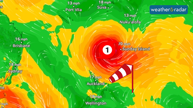
WindRadar: A tropical storm is heading towards New Zealand, bringing storm-force and gale-force winds.

A tropical storm named Vaianu is currently approaching the north of New Zealand. The centre of the storm is still over the sea, but its effects will soon be felt.

Although Vaianu will weaken slightly by Saturday, it will transform into a subtropical storm. This means it will be less compact, but significantly more extensive and unpredictable. Wind gusts of up to 75 miles per hour are still possible.

In addition, the storm system is continuing to spread. It will start affecting the north coast from Saturday evening, and during the night leading into Sunday, the ex-cyclone will move across the North Island. It will therefore affect several regions at once, not just a narrow strip.

Did you know?

Cyclone Gabrielle battered the region three years ago and was one of the costliest storms in New Zealand’s history. It brought torrential rain and caused massive damage.

There are multiple risks: heavy rain causing flooding and landslides, plus severe gusts of wind and high waves along the coast. Power cuts and transport disruption are also highly likely.

Weather & Radar editorial team
More on the topic
Temperature map of southeast England showing overnight low temperatures, with Kenley highlighted at 21.3°C and surrounding areas in yellow-orange shades indicating mild nighttime conditions.
Tuesday, 26 May 2026

May heatwave

Tropical night breaks overnight record
Split image showing a nighttime lightning strike beneath storm clouds on the left and a lightning detection map with dense storm activity across central England on the right.
Wednesday, 27 May 2026

Trickier than you think

Why it's hard to pinpoint thunderstorms
Split image showing a bright rainbow above a residential street on the left and a dramatic ocean sunrise with glowing clouds and reflections on the sea on the right.
Sunday, 24 May 2026

Your weather - Your shots

From unsettled to warm and toasty
All weather news
This might also interest you
Illustration of white and yellow fireworks on a blue background.
Wednesday, 31 December 2025

Hello 2026

Happy New Year
Weather graphic showing rain and wind fields over the Canary Islands and a central warning symbol.
Friday, 12 December 2025

Storm and rain

Turbulent weather in the Canary Islands
Outline of Santa Claus with a yellow and white hat, "Ho-Ho-Ho" next to the outline above a Christmas tree.
Thursday, 25 December 2025

Merry Christmas!

Wishes from Weather & Radar
All articles
Weather & Radar

Weather & Radar is also available on

Google Play StoreApp Store

Company

Contact us Privacy Policy Legal info Accessibility statement

Services

Uploader

Socials

facebooktwittertikToklinkList