Home
Weather London
WeatherRadar
RainfallRadar
TemperatureRadar
WindRadar
LightningRadar
Weather News
Editor's Pick
Discover the app
Weather widget
Contact us
Apps
Career
    Home / Editor's Pick /

    Tracking the tropics: Hurricane Danielle, Earl and Kay

13:00
7 September 2022

Tracking the tropics
Hurricane Danielle, Earl and Kay

Atlantic storms

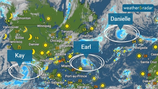
Earl has just become the latest and only second-named hurricane of this year’s 2022 Atlantic season.

According to the National Hurricane Center, Earl, the latest hurricane to be named, is sustaining winds of 85mph, with even higher gusts, though could make for a major Category 3 system by the end of the week.

Prior to Earl, Danielle, became the first of this season's Atlantic hurricanes on September 2nd and was also the first named on storm since early July. August was the first August month in 25 years to not have a single named Atlantic storm.

Danielle is currently churning away in the ocean, producing dangerous conditions in the north-central Atlantic, though is now expected to weaken through the rest of the week as it heads towards north-west Europe.

Hurricane Kay on the other hand, is presently tracking along Mexico’s Pacific coast, delivering heavy rains here, but also is expected to extend the heatwave across California, due to its easterly airflow.

Weather & Radar editorial team
More on the topic
Floods and landslides in parts of Asia. An unusual monsoon. . . Wednesday, 29 July 2026
Split image: On the left, flooded villages and fields can be seen in a vast landscape. On the right, a weather map of India shows heavy rainfall, along with a warning sign featuring a car in floodwater.
Wednesday, 29 July 2026

An unusual monsoon

Floods and landslides in parts of Asia
Heavier rainfall over the week for some. Ireland & Scotland. . . Tuesday, 28 July 2026
Split image showing a Europe rainfall accumulation forecast map on the left with the highest totals across the UK, Ireland, and Scandinavia, and a satellite weather map on the right with a broad band of rain stretching across Ireland, Scotland, and northern Britain, highlighted by a rain cloud icon.
Tuesday, 28 July 2026

Ireland & Scotland

Heavier rainfall over the week for some
Half of England now in drought. Joining North Wales. . . Wednesday, 29 July 2026
Dry section of the River Thames beneath a small stone bridge, with the riverbed exposed and cracked after prolonged, dry weather, while a person walks along the roadside above.
Wednesday, 29 July 2026

Joining North Wales

Half of England now in drought
All weather news
This might also interest you
A frozen start to the weekend. Icy conditions. . . Friday, 13 February 2026
UK temperature map dated 14.02 showing widespread subzero values in blue shading, with readings such as −4 in Glasgow, −3 in Dublin, and −2 in London, alongside a blue thermometer icon.
Friday, 13 February 2026

Icy conditions

A frozen start to the weekend
Super Typhoon Bavi threatens Taiwan. Up to 1,000 mm of rain. . . Wednesday, 8 July 2026
The image shows an intense tropical cyclone over the western Pacific, east of Taiwan and the Philippines. The centre of the system is depicted as a light purple and white vortex with a clearly visible eye, surrounded by a ring of red and orange areas indicating the strongest wind speeds. A white arrow marks the typhoon’s predicted track towards the north-west, in the direction of Taiwan. To the west of the storm lie the Philippines, with the cities of Manila and Cebu; to the north of these lies Taiwan, with Taipei. Further west, the Chinese coast, including Hong Kong, and parts of Vietnam can be seen. The coloured wind map shows predominantly green areas outside the storm’s core, indicating significantly weaker winds. White streamlines illustrate the typhoon’s anti-clockwise circulation in the Northern Hemisphere. The highest wind speeds are concentrated around the eye of the cyclone.
Wednesday, 8 July 2026

Up to 1,000 mm of rain

Super Typhoon Bavi threatens Taiwan
Bright and warm conditions take hold. Spring-like outlook. . . Thursday, 23 April 2026
Split UK map showing warm temperatures up to 21 degrees in orange on the left and clear sunny conditions with temperatures from 12 to 18 degrees on the right, with sun icons across the country.
Thursday, 23 April 2026

Spring-like outlook

Bright and warm conditions take hold
All articles
Weather & Radar

Weather & Radar is also available on

Google Play StoreApp Store

Company

Contact us Privacy Policy Legal info Accessibility statement

Services

Uploader

Socials

facebooktwittertikToklinkList