Home
Weather London
WeatherRadar
RainfallRadar
TemperatureRadar
WindRadar
LightningRadar
Weather News
Editor's Pick
Discover the app
Weather widget
Contact us
Apps
Career
    Home / Editor's Pick /

    Tornado sweeps through Italy's Foggia - So-called "landspout"

14:39
17 June 2026

So-called "landspout"
Tornado sweeps through Italy's Foggia

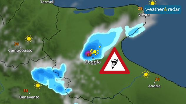
A tornado was spotted on Tuesday near Foggia in the southern Italian region of Apulia, forming beneath a thundercloud just outside the town.

The whirlwind was what is known as a "landspout". This is a tornado that does not form from a supercell. Landspouts are typically narrower and weaker than supercell tornadoes.

The WeatherRadar shows the thunderstorm from which the tornado originated.

The rotating updraft stirred up large quantities of dust from the ground, making the tornado clearly visible. Nothing is known about any damage caused.

Weather & Radar editorial team

More on the topic

Further fog disruption expected. Growing dense overnight. . . Monday, 9 November 2026
Weather map showing widespread fog across the English Midlands, with a red fog warning symbol near Nottingham and temperatures of 4–6°C.
Monday, 9 November 2026

Growing dense overnight

Further fog disruption expected
Front brings showers from the south-west. Brolly needed for some. . . Tuesday, 10 November 2026
Weather map showing blue rain bands across southern Ireland, Wales and southwest England, with a northeastward arrow and temperatures of 7–10°C.
Tuesday, 10 November 2026

Brolly needed for some

Front brings showers from the south-west
Autumn is the season for fog. High pressure, but no sun. . . Thursday, 5 November 2026
A split-screen image showing the weather radar for Europe and a mountain landscape. On the right, snow-capped peaks rise above a thick blanket of fog against a blue sky.
Thursday, 5 November 2026

High pressure, but no sun

Autumn is the season for fog
All weather news

This might also interest you

Historic Storm Éowyn arrives. On this day.... . . Saturday, 24 January 2026
Split image showing a person in a yellow jacket struggling against strong winds and heavy rain on a street at night on the left, and an Irish wind forecast map on the right with red and purple shading, gusts up to 75 mph, and a wind warning icon, divided by a curved white line.
Saturday, 24 January 2026

On this day...

Historic Storm Éowyn arrives
Super Typhoon Bavi threatens Taiwan. Up to 1,000 mm of rain. . . Wednesday, 8 July 2026
The image shows an intense tropical cyclone over the western Pacific, east of Taiwan and the Philippines. The centre of the system is depicted as a light purple and white vortex with a clearly visible eye, surrounded by a ring of red and orange areas indicating the strongest wind speeds. A white arrow marks the typhoon’s predicted track towards the north-west, in the direction of Taiwan. To the west of the storm lie the Philippines, with the cities of Manila and Cebu; to the north of these lies Taiwan, with Taipei. Further west, the Chinese coast, including Hong Kong, and parts of Vietnam can be seen. The coloured wind map shows predominantly green areas outside the storm’s core, indicating significantly weaker winds. White streamlines illustrate the typhoon’s anti-clockwise circulation in the Northern Hemisphere. The highest wind speeds are concentrated around the eye of the cyclone.
Wednesday, 8 July 2026

Up to 1,000 mm of rain

Super Typhoon Bavi threatens Taiwan
Storm Chandra makes impact. Severe gales & heavy rain. . . Tuesday, 27 January 2026
Split image showing strong winds over the UK on a forecast map and widespread rain and snow on a weather radar map.
Tuesday, 27 January 2026

Severe gales & heavy rain

Storm Chandra makes impact
All articles
Weather & Radar

Weather & Radar is also available on

Google Play StoreApp Store

Company

Contact us Privacy Policy Legal info Accessibility statement

Services

Uploader

Socials

facebooktwittertikToklinkList