Home
Weather London
WeatherRadar
RainfallRadar
TemperatureRadar
WindRadar
LightningRadar
Weather News
Editor's Pick
Discover the app
Weather widget
Contact us
Apps
Career
    Home / Editor's Pick /

    Thursday gales - Wind warnings as heavy rain approaches

09:00
12 March 2026

Thursday gales
Wind warnings as heavy rain approaches

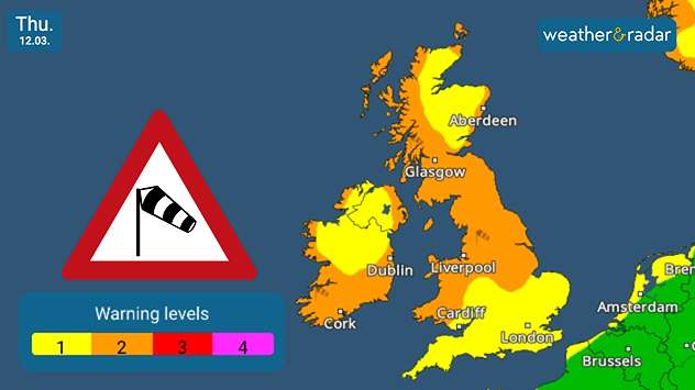
UK warning map dated Thu 12.03 showing wind warning levels in yellow and orange across Britain and Ireland, with a windsock warning icon and a legend indicating levels 1 to 4.
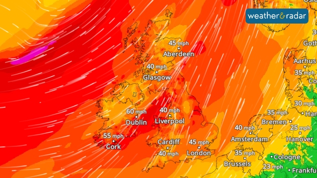
Wind forecast map showing strong winds across Ireland and the UK with orange and red shading, including gusts up to about 60 mph in Dublin, 55 mph in Cork, and around 40–45 mph across Britain.
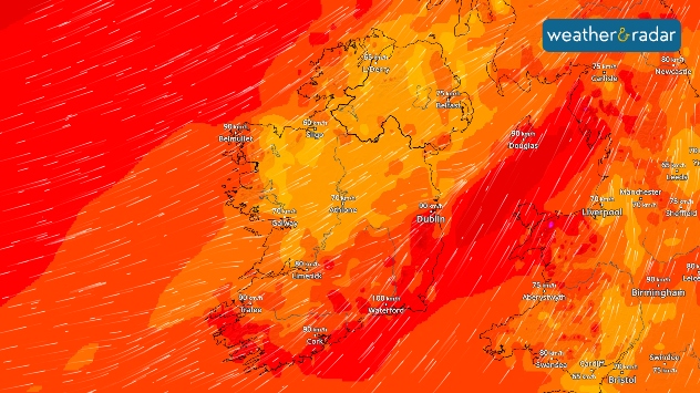
Wind forecast map showing very strong winds across Ireland and the Irish Sea with deep red shading and streamlines, including gusts around 100 km/h in Dublin and Waterford and 90 km/h near Douglas.
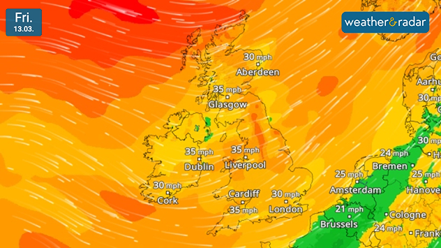
Wind forecast map dated Fri 13.03 showing widespread breezy conditions across the UK and Ireland in orange shading, with gusts around 30–35 mph in Glasgow, Dublin, Liverpool, Cardiff, and London.
1/4
Wind warnings stretch across the UK and Ireland.

Weather warnings are live as gale-force winds spread across the UK and Ireland on Thursday, with heavy rain sweeping in through the day too.

In the UK, gusts reach up to 50 mph for north-east and south-west England, possibly reaching up to 70 mph locally, at and around higher altitudes.

For Ireland, gusts are slightly stronger, especially around coastal areas with peaks of 90 - 100 km/h (55 - 60 mph) widely felt, losing power inland.

Rain also moves through during the day, initially over Ireland and Scotland from the morning before heading south-east through England and Wales.

This moves away from the north though the day as winds also ease a little. For higher altitudes in Scotland and northern England, wintry snow showers are possible.

Jet stream picking up speedThe cause of it all
Ryan Hathaway
More on the topic
Heavier rainfall over the week for some. Ireland & Scotland. . . Tuesday, 28 July 2026
Split image showing a Europe rainfall accumulation forecast map on the left with the highest totals across the UK, Ireland, and Scandinavia, and a satellite weather map on the right with a broad band of rain stretching across Ireland, Scotland, and northern Britain, highlighted by a rain cloud icon.
Tuesday, 28 July 2026

Ireland & Scotland

Heavier rainfall over the week for some
Typhoon warning for China. Up to 500 mm of rain. . . Friday, 24 July 2026
Weather map of the southern Chinese coast and Taiwan showing a powerful tropical cyclone. The eye of the storm is located near the coastal city of Shantou in the Chinese province of Guangdong. Around the centre, intense shades of red, pink and violet indicate gale-force winds, whilst a large orange wind field extends as far as the west coast of Taiwan. An overlaid windsack warning sign indicates dangerous storm winds. Cities such as Hong Kong, Guangzhou, Xiamen, Taipei and Taichung are shown, as are wind speeds and white flow lines illustrating the cyclonic air circulation.
Friday, 24 July 2026

Up to 500 mm of rain

Typhoon warning for China
Rain returns to end dry spell in places. Jet stream delivery. . . Thursday, 23 July 2026
Split weather graphic showing widespread showers across the UK and Ireland on the left, and a wind forecast map on the right with a windsock icon and gusts of 25 to 35 mph, highlighting breezy conditions across the two countries.
Thursday, 23 July 2026

Jet stream delivery

Rain returns to end dry spell in places
All weather news
This might also interest you
Super Typhoon Bavi threatens Taiwan. Up to 1,000 mm of rain. . . Wednesday, 8 July 2026
The image shows an intense tropical cyclone over the western Pacific, east of Taiwan and the Philippines. The centre of the system is depicted as a light purple and white vortex with a clearly visible eye, surrounded by a ring of red and orange areas indicating the strongest wind speeds. A white arrow marks the typhoon’s predicted track towards the north-west, in the direction of Taiwan. To the west of the storm lie the Philippines, with the cities of Manila and Cebu; to the north of these lies Taiwan, with Taipei. Further west, the Chinese coast, including Hong Kong, and parts of Vietnam can be seen. The coloured wind map shows predominantly green areas outside the storm’s core, indicating significantly weaker winds. White streamlines illustrate the typhoon’s anti-clockwise circulation in the Northern Hemisphere. The highest wind speeds are concentrated around the eye of the cyclone.
Wednesday, 8 July 2026

Up to 1,000 mm of rain

Super Typhoon Bavi threatens Taiwan
A frozen start to the weekend. Icy conditions. . . Friday, 13 February 2026
UK temperature map dated 14.02 showing widespread subzero values in blue shading, with readings such as −4 in Glasgow, −3 in Dublin, and −2 in London, alongside a blue thermometer icon.
Friday, 13 February 2026

Icy conditions

A frozen start to the weekend
Storm Chandra makes impact. Severe gales & heavy rain. . . Tuesday, 27 January 2026
Split image showing strong winds over the UK on a forecast map and widespread rain and snow on a weather radar map.
Tuesday, 27 January 2026

Severe gales & heavy rain

Storm Chandra makes impact
All articles
Weather & Radar

Weather & Radar is also available on

Google Play StoreApp Store

Company

Contact us Privacy Policy Legal info Accessibility statement

Services

Uploader

Socials

facebooktwittertikToklinkList