Home
Weather London
WeatherRadar
RainfallRadar
TemperatureRadar
WindRadar
LightningRadar
Weather News
Editor's Pick
Discover the app
Weather widget
Contact us
Apps
Career
    Home / Editor's Pick /

    Thunderstorms & tornadoes: Enormous storm front passing over U.S.

11:00
15 March 2024

Thunderstorms & tornadoes
Enormous storm front passing over U.S.

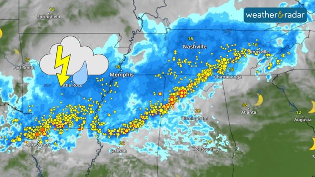
Weather map showing thunderstorms over the U.S
The storm front is over 1,200 km long and currently passes through at least four states on the WeatherRadar.

A massive storm front is passing over the US, bringing thunderstorms and tornadoes to a large area, with lightning strikes almost every second.

The states of Ohio and Indiana in the north-west of the country are particularly affected. At least eight tornadoes have already caused a swathe of devastation there.

The communities of Wapakoneta and Indian Lakes in Ohio were the worst hit. At least two people lost their lives while around 20,000 households lost power.

Privacy Policy

Snow ploughs are being used to remove the debris from the roads, though further damage is likely to be discovered after sunrise local time.

Tornadoes in the UK and Ireland?read more

Thunderstorms continue to impact an enormous area stretching from Texas, through Mississippi and Alabama, reaching Tennessee.

See it on the WeatherRadar

The large storm front is clearly visible on the WeatherRadar, where you can now see live lightning strikes, as well as our existing LightningRadar.

Lightning strikes are now visible on the WeatherRadar, where surrounding weather conditions are also shown.

While the dedicated LightningRadar, presents just lighting on a clear map, with strikes recorded around the world and displayed on the radar in the form of yellow dots, those with red outlines are the most recently captured.

The new lightning feature on the WeatherRadar is available now for all users. Just open up the radar and start exploring the world via thunderstorms!

Weather & Radar editorial team
More on the topic
More rain needed to ease drought. Reservoirs still falling. . . Tuesday, 8 September 2026
Aerial view of a depleted reservoir with exposed banks and a narrow winding stream through the dry basin, surrounded by green hills and roads.
Tuesday, 8 September 2026

Reservoirs still falling

More rain needed to ease drought
Record ocean heat halting hurricanes. Strong El Niño influence. . . Friday, 11 September 2026
A weather map shows a calm Atlantic Ocean with no hurricanes, alongside a picture of the sea.
Friday, 11 September 2026

Strong El Niño influence

Record ocean heat halting hurricanes
Severe weather hits Mallorca and Italy. Severe thunderstorms. . . Thursday, 10 September 2026
Numerous thunderstorms are sweeping across La Palma. The many lightning symbols on the radar and lightning map show that there is heavy lightning activity across large parts of the island. The thunderstorms are striking particularly in the island’s interior and in the south. On the right, you can see the aftermath: a large fallen tree has buried a car beneath it. Emergency services are clearing up the damage. So, along with the thunderstorms, not only heavy rain but also gusts of wind can become a problem.
Thursday, 10 September 2026

Severe thunderstorms

Severe weather hits Mallorca and Italy
All weather news
This might also interest you
New records for England and Wales. Broken again tomorrow?. . . Thursday, 25 June 2026
Temperature map of southwest Britain on 25.06 showing extreme heat across southern Wales and southwest England, with Bute Park in Cardiff highlighted at 34.2°C and Yeovilton at 36.4°C amid widespread deep red heat zones.
Thursday, 25 June 2026

Broken again tomorrow?

New records for England and Wales
Seasonal warmth between spring thunder. Your weather - Your shots. . . Sunday, 19 April 2026
Split image showing coastal sunset with layered lenticular clouds over rooftops and palm trees on the left, and a green valley with river and hills under soft daylight on the right.
Sunday, 19 April 2026

Your weather - Your shots

Seasonal warmth between spring thunder
Flooding, gales, and heavy snow. Storm Chandra. . . Tuesday, 27 January 2026
Split image showing aerial flooding in a town with muddy water covering roads on the left, and a rural road on the right blocked by heavy snowfall with vans stopped and a person walking in snow.
Tuesday, 27 January 2026

Storm Chandra

Flooding, gales, and heavy snow
All articles
Weather & Radar

Weather & Radar is also available on

Google Play StoreApp Store

Company

Contact us Privacy Policy Legal info Accessibility statement

Services

Uploader

Socials

facebooktwittertikToklinkList