Home
Weather London
WeatherRadar
RainfallRadar
TemperatureRadar
WindRadar
LightningRadar
Weather News
Editor's Pick
Discover the app
Weather widget
Contact us
Apps
Career
    Home / Editor's Pick /

    Thunderstorms and tornadoes - A sudden change in weather for Europe

11:00
2 July 2026

Thunderstorms & tornadoes
A sudden change in weather for Europe

In many parts of central and eastern Europe, violent thunderstorms yesterday brought an end to the spell of extreme heat.

The hot, humid air created ideal conditions for severe thunderstorms, bringing frequent lightning strikes, large hailstones, heavy rain, damaging winds, and even tornadoes.

There was damage and travel disruption in some areas, caused, amongst other things, by flooded roads, landslides, and fallen trees.

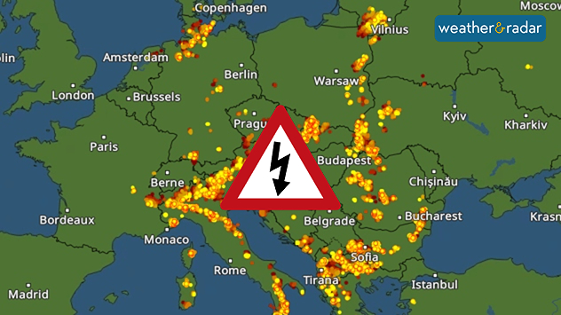
Lightning map of Europe showing widespread thunderstorm activity across central and southeastern Europe, with dense lightning strike clusters around the Alps, northern Italy, the Balkans, and central Europe, plus a thunderstorm warning symbol.
On Wednesday evening, LightningRadar shows numerous lightning strikes, particularly from northern Italy to Eastern Europe.

Today, there will be further thunderstorms, some of which may be severe, mainly from Italy across the Balkans to Ukraine. Meanwhile, sunnier and more settled summer weather is set to prevail in western and central Europe.

There are currently flashes of light hereLightningRadar
Michael Krucker
More on the topic
Rain returns to end dry spell in places. Jet stream delivery. . . Thursday, 23 July 2026
Split weather graphic showing widespread showers across the UK and Ireland on the left, and a wind forecast map on the right with a windsock icon and gusts of 25 to 35 mph, highlighting breezy conditions across the two countries.
Thursday, 23 July 2026

Jet stream delivery

Rain returns to end dry spell in places
Drought for North Wales and Upper Severn. 2% of average rainfall. . . Thursday, 23 July 2026
Split image showing a July rainfall anomaly map of Europe on the left with below-average rainfall across the UK, Ireland, and much of western and central Europe, and an active moorland wildfire on the right producing flames and thick smoke near homes.
Thursday, 23 July 2026

2% of average rainfall

Drought for North Wales and Upper Severn
Heat becoming a bigger factor in drought. New study. . . Thursday, 23 July 2026
A hand holds dry, dusty earth above a parched field. The ground is cracked and covered with plant debris – a sign of prolonged drought.
Thursday, 23 July 2026

New study

Heat becoming a bigger factor in drought
All weather news
This might also interest you
Turbulent weather in the Canary Islands. Storm and rain. . . Friday, 12 December 2025
Weather graphic showing rain and wind fields over the Canary Islands and a central warning symbol.
Friday, 12 December 2025

Storm and rain

Turbulent weather in the Canary Islands
Historic Storm Éowyn arrives. On this day.... . . Saturday, 24 January 2026
Split image showing a person in a yellow jacket struggling against strong winds and heavy rain on a street at night on the left, and an Irish wind forecast map on the right with red and purple shading, gusts up to 75 mph, and a wind warning icon, divided by a curved white line.
Saturday, 24 January 2026

On this day...

Historic Storm Éowyn arrives
A frozen start to the weekend. Icy conditions. . . Friday, 13 February 2026
UK temperature map dated 14.02 showing widespread subzero values in blue shading, with readings such as −4 in Glasgow, −3 in Dublin, and −2 in London, alongside a blue thermometer icon.
Friday, 13 February 2026

Icy conditions

A frozen start to the weekend
All articles
Weather & Radar

Weather & Radar is also available on

Google Play StoreApp Store

Company

Contact us Privacy Policy Legal info Accessibility statement

Services

Uploader

Socials

facebooktwittertikToklinkList