Home
Weather London
WeatherRadar
RainfallRadar
TemperatureRadar
WindRadar
LightningRadar
Weather News
Editor's Pick
Discover the app
Weather widget
Contact us
Apps
Career
    Home / Editor's Pick /

    Thunderstorm season begins in the US – increased risk of tornadoes, large hailstones possible

13:01
5 March 2026

Tornado risk increases
Thunderstorm season begins in the US

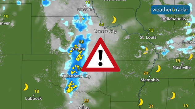
Thunderstorm season is beginning in the US. On Thursday and Friday, the risk of severe weather will increase significantly in the south and Midwest.

See current thunderstorms in the USLightningRadar

This can lead to the formation of individual supercells with large hailstones and severe squalls. Tornadoes cannot be ruled out in organised thunderstorm lines.

Into Friday morning, isolated thunderstorm cells may form again in the Midwest.

The regions from North Texas to Oklahoma and Kansas are particularly at risk. But parts of Nebraska, Illinois and Indiana could also be hit hard.

Did you know?

The supercell is considered the "queen" of thunderstorm types and often causes severe damage.

This is caused by warm, humid air from the Gulf meeting colder air from the north. A low-pressure system is adding extra dynamism to the weather. Its distinctive cold front, which is moving from the north-west to the south-east, is causing a drop in temperature.

Tommy Kühnlein
More on the topic
Late season views as summer rolls on. Your weather - Your shots. . . Sunday, 9 August 2026
Split image showing a horseback ride along a green hillside trail beneath blue skies on the left and a small sailboat on a calm coastal bay under broken clouds on the right.
Sunday, 9 August 2026

Your weather - Your shots

Late season views as summer rolls on
Solar eclipse on Wednesday. Save the date. . . Monday, 10 August 2026
People are watching a solar eclipse. The sun is already partially obscured. Next to it is the weather radar forecast for Wednesday, showing an almost cloudless sky.
Monday, 10 August 2026

Save the date

Solar eclipse on Wednesday
Cooler nights on the horizon. For parts of Europe. . . Thursday, 6 August 2026
Temperature Radar showing the night-time lows in Central Europe. Cooler air is reaching the west and north in particular, whilst the south-east remains significantly warmer.
Thursday, 6 August 2026

For parts of Europe

Cooler nights on the horizon
All weather news
This might also interest you
Seasonal warmth between spring thunder. Your weather - Your shots. . . Sunday, 19 April 2026
Split image showing coastal sunset with layered lenticular clouds over rooftops and palm trees on the left, and a green valley with river and hills under soft daylight on the right.
Sunday, 19 April 2026

Your weather - Your shots

Seasonal warmth between spring thunder
Flooding, gales, and heavy snow. Storm Chandra. . . Tuesday, 27 January 2026
Split image showing aerial flooding in a town with muddy water covering roads on the left, and a rural road on the right blocked by heavy snowfall with vans stopped and a person walking in snow.
Tuesday, 27 January 2026

Storm Chandra

Flooding, gales, and heavy snow
Storm Chandra makes impact. Severe gales & heavy rain. . . Tuesday, 27 January 2026
Split image showing strong winds over the UK on a forecast map and widespread rain and snow on a weather radar map.
Tuesday, 27 January 2026

Severe gales & heavy rain

Storm Chandra makes impact
All articles
Weather & Radar

Weather & Radar is also available on

Google Play StoreApp Store

Company

Contact us Privacy Policy Legal info Accessibility statement

Services

Uploader

Socials

facebooktwittertikToklinkList