Home
Weather London
WeatherRadar
RainfallRadar
TemperatureRadar
WindRadar
LightningRadar
Weather News
Editor's Pick
Discover the app
Weather widget
Contact us
Apps
Career
    Home / Editor's Pick /

    Thunderstorm outbreaks: Stormy weekend ahead

08:00
17 July 2025

Thunderstorm outbreaks
Stormy weekend ahead

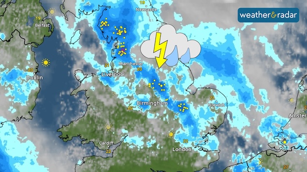
UK weather radar map showing widespread showers and thunderstorms across northern and central England, highlighted by yellow lightning strike markers. A storm symbol with cloud and lightning indicates active thunderstorm risk around the Manchester and Leeds areas. Brighter conditions are seen over southern Ireland and Wales, with some sun icons visible.
Saturday sees thunderstorms sweep across England.

Multiple low-pressure systems in the coming days will bring heavy rain over the weekend, turning stormy at times.

With an initial outbreak over parts of Northern Ireland on Thursday, by Saturday, widespread thunderstorms are possible across England.

Despite this, it will remain mostly calm in terms of winds. Only those in southern Ireland, and south-west England can expect a return of strong gusts, up to around 40 mph (64 km/h).

Preparing for a floodread also
Ryan Hathaway
More on the topic
Drought for North Wales and Upper Severn. 2% of average rainfall. . . Thursday, 23 July 2026
Split image showing a July rainfall anomaly map of Europe on the left with below-average rainfall across the UK, Ireland, and much of western and central Europe, and an active moorland wildfire on the right producing flames and thick smoke near homes.
Thursday, 23 July 2026

2% of average rainfall

Drought for North Wales and Upper Severn
Fourth heatwave of the year. Peaking Wednesday. . . Tuesday, 28 July 2026
Temperature map of England and Wales on Wednesday 29.07 showing widespread hot conditions, with temperatures reaching 33°C near Cambridge, 32°C around London, Norwich, and Southend-on-Sea, and a large heat warning symbol highlighting elevated heat risk.
Tuesday, 28 July 2026

Peaking Wednesday

Fourth heatwave of the year
UV levels peak with the heat today. Latest heatwave. . . Wednesday, 29 July 2026
Split graphic showing a temperature map of England and eastern Ireland with temperatures reaching 33°C near London, 32°C in Norwich, and 29°C around Birmingham on the left, alongside a person applying sunscreen with a UV icon on the right.
Wednesday, 29 July 2026

Latest heatwave

UV levels peak with the heat today
All weather news
This might also interest you
Historic Storm Éowyn arrives. On this day.... . . Saturday, 24 January 2026
Split image showing a person in a yellow jacket struggling against strong winds and heavy rain on a street at night on the left, and an Irish wind forecast map on the right with red and purple shading, gusts up to 75 mph, and a wind warning icon, divided by a curved white line.
Saturday, 24 January 2026

On this day...

Historic Storm Éowyn arrives
Bright and warm conditions take hold. Spring-like outlook. . . Thursday, 23 April 2026
Split UK map showing warm temperatures up to 21 degrees in orange on the left and clear sunny conditions with temperatures from 12 to 18 degrees on the right, with sun icons across the country.
Thursday, 23 April 2026

Spring-like outlook

Bright and warm conditions take hold
Seasonal warmth between spring thunder. Your weather - Your shots. . . Sunday, 19 April 2026
Split image showing coastal sunset with layered lenticular clouds over rooftops and palm trees on the left, and a green valley with river and hills under soft daylight on the right.
Sunday, 19 April 2026

Your weather - Your shots

Seasonal warmth between spring thunder
All articles
Weather & Radar

Weather & Radar is also available on

Google Play StoreApp Store

Company

Contact us Privacy Policy Legal info Accessibility statement

Services

Uploader

Socials

facebooktwittertikToklinkList