Home
Weather London
WeatherRadar
RainfallRadar
TemperatureRadar
WindRadar
LightningRadar
Weather News
Editor's Pick
Discover the app
Weather widget
Contact us
Apps
Career
    Home /

    Temperatures are expected to drop, but the bulk of the rain doesn't fall where it's needed the most

16:30
3 August 2026

Not much rain in south
Wet northwest, brighter elsewhere

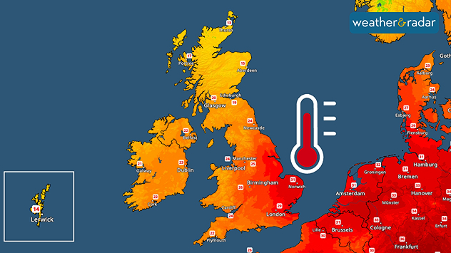
Temperature map of the UK and surrounding areas on Tuesday
One more hot day for the south and east on Tuesday.

Temperatures will be closer to normal values after a hot start, but the bulk of the rain doesn't fall where it's needed the most.

The contrast we have seen recently is set to continue this week. While western and northern areas see spells of rain and brisk winds at times, southern and eastern regions are likely to stay drier and sunnier.

Tuesday is another hot day in the south and east, with plenty of sunshine pushing temperatures into the high 20's or low 30's across southeastern and eastern England.

Cloud and outbreaks of rain will meanwhile move across Ireland, Wales and northern parts of the UK. Even a few heavy, thundery downpours are possible through the day.

Fresher air will finally arrive in the south and east on Wednesday with some cloud and a few showers moving through as well.

Further north and west, renewed outbreaks of rain are expected as winds become strong and gusty at times, especially around the coasts and over higher ground.

Looking ahead, the northwest-southeast split is likely to continue into the latter half of the week. Further showers or longer spells of rain should affect Ireland, northern England and Scotland.

Southern and eastern parts of England will see plenty of dry and bright or sunny conditions with only a few passing showers.

Unfortunately, this also means that the areas most affected by the ongoing drought are likely to miss out on the heaviest rainfall.

London

Mo
19
30
Tu
19
29
We
19
25
Th
15
22
Fr
14
24
Sa
16
25
Su
17
25
Mo
17
25
Tu
17
27
We
18
29
Th
19
30
Fr
19
27
Sa
17
25
Su
17
26
Max (°C)
Min (°C)
moreless

Leeds

Mo
14
27
Tu
15
27
We
17
20
Th
14
19
Fr
11
21
Sa
10
24
Su
14
22
Mo
13
21
Tu
13
22
We
13
24
Th
13
25
Fr
14
23
Sa
14
22
Su
13
22
Max (°C)
Min (°C)
moreless

Dublin

Mo
15
21
Tu
15
23
We
14
19
Th
12
18
Fr
10
20
Sa
15
20
Su
12
20
Mo
11
19
Tu
12
21
We
12
21
Th
13
22
Fr
14
22
Sa
13
22
Su
12
21
Max (°C)
Min (°C)
moreless

Edinburgh

Mo
12
18
Tu
14
19
We
16
18
Th
12
17
Fr
10
18
Sa
13
19
Su
13
20
Mo
12
20
Tu
13
20
We
12
21
Th
13
21
Fr
13
21
Sa
13
21
Su
14
21
Max (°C)
Min (°C)
moreless

Swansea

Mo
14
26
Tu
19
22
We
15
20
Th
12
19
Fr
11
20
Sa
13
22
Su
16
21
Mo
15
21
Tu
15
22
We
16
24
Th
16
22
Fr
17
22
Sa
16
21
Su
16
21
Max (°C)
Min (°C)
moreless
Lars Lowinski
More on the topic
Europe’s seas are unusually warm. Up to 30 degrees. . . Friday, 31 July 2026
Friday, 31 July 2026

Up to 30 degrees

Europe’s seas are unusually warm
Vibrant skies for the last week of July. Your weather - Your shots. . . Sunday, 2 August 2026
Split image showing a golden-orange countryside sunset with silhouetted trees and birds on the left, and glowing blue-white noctilucent clouds rippling across the twilight sky above trees and a lake on the right.
Sunday, 2 August 2026

Your weather - Your shots

Vibrant skies for the last week of July
Forest fires spread to south-east Europe. Heat and strong winds. . . Thursday, 30 July 2026
Split image showing an active wildfire with flames and thick smoke on the left, and a wind forecast map of Greece on the right with gusts of 25–35 mph around the Aegean Sea, alongside a wildfire warning symbol highlighting elevated fire danger.
Thursday, 30 July 2026

Heat and strong winds

Forest fires spread to south-east Europe
All weather news
This might also interest you
Typhoon warning for China. Up to 500 mm of rain. . . Friday, 24 July 2026
Weather map of the southern Chinese coast and Taiwan showing a powerful tropical cyclone. The eye of the storm is located near the coastal city of Shantou in the Chinese province of Guangdong. Around the centre, intense shades of red, pink and violet indicate gale-force winds, whilst a large orange wind field extends as far as the west coast of Taiwan. An overlaid windsack warning sign indicates dangerous storm winds. Cities such as Hong Kong, Guangzhou, Xiamen, Taipei and Taichung are shown, as are wind speeds and white flow lines illustrating the cyclonic air circulation.
Friday, 24 July 2026

Up to 500 mm of rain

Typhoon warning for China
Fourth heatwave of the year. Peaking Wednesday. . . Tuesday, 28 July 2026
Temperature map of England and Wales on Wednesday 29.07 showing widespread hot conditions, with temperatures reaching 33°C near Cambridge, 32°C around London, Norwich, and Southend-on-Sea, and a large heat warning symbol highlighting elevated heat risk.
Tuesday, 28 July 2026

Peaking Wednesday

Fourth heatwave of the year
Forest fires are getting out of control. Spain and France. . . Saturday, 25 July 2026
A split-screen image featuring a photograph and a weather map. On the left, thick, dark-grey smoke rises from several fire sites in a wooded coastal area; a calm stretch of water can be seen in the foreground. On the right, a weather map shows south-western France and northern Spain. A red arrow points from the Atlantic towards the French Atlantic coast, symbolising an onshore wind. Sunny weather is forecast for Bordeaux at around 20 degrees, and Bilbao is also expected to be sunny at around 27 degrees. A large warning sign with a flame symbol indicates an increased risk of forest fires.
Saturday, 25 July 2026

Spain and France

Forest fires are getting out of control
All articles
Weather & Radar

Weather & Radar is also available on

Google Play StoreApp Store

Company

Contact us Privacy Policy Legal info Accessibility statement

Services

Uploader

Socials

facebooktwittertikToklinkList