Home
Weather London
WeatherRadar
RainfallRadar
TemperatureRadar
WindRadar
LightningRadar
Weather News
Editor's Pick
Discover the app
Weather widget
Contact us
Apps
Career
    Home / Editor's Pick /

    Temperature drop in Europe towards the weekend - Lots of fresh snow in the western Alps

14:00
12 March 2026

Lots of snow in the Alps
Temperature drop at the weekend

There will be a drop in temperatures in western and central Europe over the weekend as a low-pressure system brings significantly colder air from the north-west.

With the cooler air, snow is falling again in the low mountain ranges and the Alps. At lower altitudes, it will mostly remain rainy. Overall, the weather will be changeable with strong winds at times.

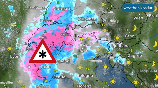
Weather map of the Alps with radar image. Above Switzerland and northern Italy, a symbol indicates snowfall in a large precipitation area over the western Alps.
Particularly from the Swiss Alps to the Maritime Alps in France, 50 to 100 centimetres of fresh snow is expected.

There is a lot of fresh snow, especially in the Western Alps. A low-pressure system is forming over the western Mediterranean, directing moist air towards the Alps. There is heavy precipitation there, which falls as snow in many valleys due to the cold air.

On Saturday night, clear skies will bring frost in some areas. This will mainly affect parts of France, the Benelux countries, western Germany and the Alpine region.

The picture is similar in the UK and Ireland, where temperatures drop to and around freezing by Saturday.

Tommy Kühnlein
More on the topic
Hurricane Lowell threatens Hawaii. Gales and flash floods. . . Tuesday, 8 September 2026
WindRadar showing Hurricane Lowell north-west of Hawaii and its well-defined storm centre.
Tuesday, 8 September 2026

Gales and flash floods

Hurricane Lowell threatens Hawaii
Autumn arrives with vivid colour. Your weather - Your shots. . . Sunday, 6 September 2026
Split image showing peach-lit textured clouds above silhouetted trees and golden cumulus clouds reflected in a calm canal lined with boats.
Sunday, 6 September 2026

Your weather - Your shots

Autumn arrives with vivid colour
Record ocean heat halting hurricanes. Strong El Niño influence. . . Friday, 11 September 2026
A weather map shows a calm Atlantic Ocean with no hurricanes, alongside a picture of the sea.
Friday, 11 September 2026

Strong El Niño influence

Record ocean heat halting hurricanes
All weather news
This might also interest you
Historic Storm Éowyn arrives. On this day.... . . Saturday, 24 January 2026
Split image showing a person in a yellow jacket struggling against strong winds and heavy rain on a street at night on the left, and an Irish wind forecast map on the right with red and purple shading, gusts up to 75 mph, and a wind warning icon, divided by a curved white line.
Saturday, 24 January 2026

On this day...

Historic Storm Éowyn arrives
A stormy week in the skies above. Your weather - Your shots. . . Sunday, 30 August 2026
Split image showing lightning branching beneath dark storm clouds above rooftops on the left and an orange-pink sunset over a calm sea on the right.
Sunday, 30 August 2026

Your weather - Your shots

A stormy week in the skies above
Bright and warm conditions take hold. Spring-like outlook. . . Thursday, 23 April 2026
Split UK map showing warm temperatures up to 21 degrees in orange on the left and clear sunny conditions with temperatures from 12 to 18 degrees on the right, with sun icons across the country.
Thursday, 23 April 2026

Spring-like outlook

Bright and warm conditions take hold
All articles
Weather & Radar

Weather & Radar is also available on

Google Play StoreApp Store

Company

Contact us Privacy Policy Legal info Accessibility statement

Services

Uploader

Socials

facebooktwittertikToklinkList