Home
Weather London
WeatherRadar
RainfallRadar
TemperatureRadar
WindRadar
LightningRadar
Weather News
Editor's Pick
Discover the app
Weather widget
Contact us
Apps
Career
    Home / Editor's Pick /

    Super typhoon near the Philippines - Gusts of up to 155 mph

10:00
23 June 2026

Gusts of up to 155 mph
Super typhoon near the Philippines

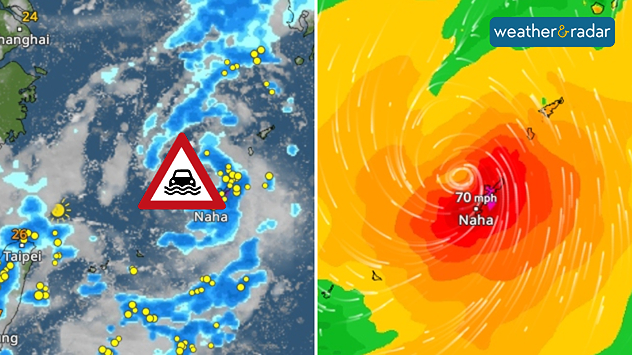
An exceptionally powerful cyclone has developed over the western Pacific. Typhoon Mekkhala even reached super typhoon strength at times east of the Philippines with wind gusts of up to nearly 155 miles per hour.

Over the coming days, Mekkhala will move northwards and remain over the open sea for the time being. The typhoon’s current track takes it east of Taiwan. People on Japan’s southernmost islands, the Ryukyu Islands, in particular, are now watching its further development with keen interest.

Mekkhala is heading for Japan’s southernmost islands. Heavy rain could lead to flooding with a risk of gale-force winds.

Its exact path is still uncertain. If Mekkhala moves closer, conditions there could become unpleasant, with gale-force winds and huge waves.

Tommy Kühnlein
More on the topic
Warm waters raise severe weather risk. Mediterranean bathtub. . . Friday, 4 September 2026
Left: Map showing water temperatures in the Mediterranean; Right: Dark clouds over a stretch of Mediterranean coastline. A bolt of lightning strikes and a curtain of rain can be seen.
Friday, 4 September 2026

Mediterranean bathtub

Warm waters raise severe weather risk
Record ocean heat halting hurricanes. Strong El Niño influence. . . Friday, 11 September 2026
A weather map shows a calm Atlantic Ocean with no hurricanes, alongside a picture of the sea.
Friday, 11 September 2026

Strong El Niño influence

Record ocean heat halting hurricanes
A marked change in the weather. Cold front heading south. . . Monday, 7 September 2026
Map of Europe showing a cold front stretching from Scandinavia to Spain. Thunderstorms are shown in southern and central Europe.
Monday, 7 September 2026

Cold front heading south

A marked change in the weather
All weather news
This might also interest you
Seasonal warmth between spring thunder. Your weather - Your shots. . . Sunday, 19 April 2026
Split image showing coastal sunset with layered lenticular clouds over rooftops and palm trees on the left, and a green valley with river and hills under soft daylight on the right.
Sunday, 19 April 2026

Your weather - Your shots

Seasonal warmth between spring thunder
Flooding, gales, and heavy snow. Storm Chandra. . . Tuesday, 27 January 2026
Split image showing aerial flooding in a town with muddy water covering roads on the left, and a rural road on the right blocked by heavy snowfall with vans stopped and a person walking in snow.
Tuesday, 27 January 2026

Storm Chandra

Flooding, gales, and heavy snow
Historic Storm Éowyn arrives. On this day.... . . Saturday, 24 January 2026
Split image showing a person in a yellow jacket struggling against strong winds and heavy rain on a street at night on the left, and an Irish wind forecast map on the right with red and purple shading, gusts up to 75 mph, and a wind warning icon, divided by a curved white line.
Saturday, 24 January 2026

On this day...

Historic Storm Éowyn arrives
All articles
Weather & Radar

Weather & Radar is also available on

Google Play StoreApp Store

Company

Contact us Privacy Policy Legal info Accessibility statement

Services

Uploader

Socials

facebooktwittertikToklinkList