Home
Weather London
WeatherRadar
RainfallRadar
TemperatureRadar
WindRadar
LightningRadar
Weather News
Editor's Pick
Discover the app
Weather widget
Contact us
Apps
Career
    Home / Weather News /

    Super Typhoon Bavi threatens Taiwan – Up to 1,000 mm of rain

10:00
8 July 2026

Up to 1,000 mm of rain
Super Typhoon Bavi threatens Taiwan

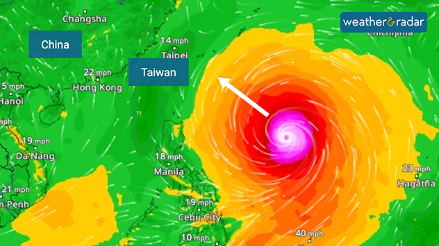
The powerful typhoon Bavi in the Western Pacific is currently heading towards Taiwan. It is expected to cross the north of the island during the overnight into Saturday, impacting capital city, Taipei.

Hurricane-force winds of over 125 miles per hour, waves around 10 metres high, and heavy rainfall of up to 1,000 mm are expected. That is an extremely large amount. As a result, there are fears of widespread flooding and landslides.

WindRadar shows the typhoon, which is now moving towards Taiwan.

The typhoon has a diameter of around 1,000 kilometres, which is unusually large for a cyclone. Allowing the system to bring prolonged rainfall as it crosses the island, which also explains the high accumulation totals.

After passing over Taiwan, Bavi makes landfall on the east coast of China in a slightly weakened form. By then, both the rainfall and the gusts of wind are no longer quite as severe.

Did you know?

Super typhoons are among the strongest tropical cyclones in the world and are equivalent to a Category 5 hurricane.

Over the past few days, the storm has already hit the Mariana Islands. Wind gusts of over 185 mph were recorded there, and numerous buildings were destroyed.

One reason for the high number of powerful typhoons could be El Niño, which causes sea temperatures in the eastern Pacific to rise. During an El Niño event, the likelihood of powerful cyclones in the Pacific generally increases.

Verena Leyendecker
More on the topic
Warm waters raise severe weather risk. Mediterranean bathtub. . . Friday, 4 September 2026
Left: Map showing water temperatures in the Mediterranean; Right: Dark clouds over a stretch of Mediterranean coastline. A bolt of lightning strikes and a curtain of rain can be seen.
Friday, 4 September 2026

Mediterranean bathtub

Warm waters raise severe weather risk
Hurricane Lowell threatens Hawaii. Gales and flash floods. . . Tuesday, 8 September 2026
WindRadar showing Hurricane Lowell north-west of Hawaii and its well-defined storm centre.
Tuesday, 8 September 2026

Gales and flash floods

Hurricane Lowell threatens Hawaii
Hottest summer on record for Ireland. Beating 2025's record. . . Thursday, 3 September 2026
Temperature map of Ireland showing 29°C in Dublin, 26°C in Cork, 24°C in Belfast, and 23°C in Galway, with a red thermometer icon.
Thursday, 3 September 2026

Beating 2025's record

Hottest summer on record for Ireland
All weather news
This might also interest you
Historic Storm Éowyn arrives. On this day.... . . Saturday, 24 January 2026
Split image showing a person in a yellow jacket struggling against strong winds and heavy rain on a street at night on the left, and an Irish wind forecast map on the right with red and purple shading, gusts up to 75 mph, and a wind warning icon, divided by a curved white line.
Saturday, 24 January 2026

On this day...

Historic Storm Éowyn arrives
Storm Chandra makes impact. Severe gales & heavy rain. . . Tuesday, 27 January 2026
Split image showing strong winds over the UK on a forecast map and widespread rain and snow on a weather radar map.
Tuesday, 27 January 2026

Severe gales & heavy rain

Storm Chandra makes impact
A stormy week in the skies above. Your weather - Your shots. . . Sunday, 30 August 2026
Split image showing lightning branching beneath dark storm clouds above rooftops on the left and an orange-pink sunset over a calm sea on the right.
Sunday, 30 August 2026

Your weather - Your shots

A stormy week in the skies above
All articles
Weather & Radar

Weather & Radar is also available on

Google Play StoreApp Store

Company

Contact us Privacy Policy Legal info Accessibility statement

Services

Uploader

Socials

facebooktwittertikToklinkList