Home
Weather London
WeatherRadar
RainfallRadar
TemperatureRadar
WindRadar
LightningRadar
Weather News
Editor's Pick
Discover the app
Weather widget
Contact us
Apps
Career
    Home / Editor's Pick /

    Strong winds and rain - Hurricane reaches the Azores

08:00
26 September 2025

Strong winds and rain
Hurricane reaches the Azores

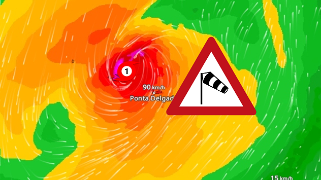
A weather map shows Hurricane Gabrielle over the Azores with wind speeds of around 90 kilometres per hour. A storm warning symbol is displayed.
WindRadar: GABRIELLE passed directly over the Azores.

Hurricane GABRIELLE reached the Azores on Friday morning. The western and central islands were particularly affected.

In Horta on the island of Faial, a weather station recorded gusts of more than 120 kilometres per hour. Portuguese media even reported speeds of more than 150 kilometres per hour.

GABRIELLE on WindRadarread more

In addition, heavy rainfall has hit the archipelago. Initial reports indicate damage from fallen trees, blocked roads and destroyed roofs. So far, there have been no casualties.

Privacy Policy

This is an unusual event for the Azores. GABRIELLE is only the 10th recorded hurricane to hit the archipelago. The last hurricane to graze the islands was GORDON in 2012.

Now heading for Portugal

GABRIELLE is now rapidly weakening and moving further eastwards. On Sunday, the former hurricane will hit Portugal and then move on to south-western Spain.

There, coastal areas are threatened by storm gusts, high waves and heavy rainfall extending inland. However, this is not comparable to the effects on the Azores.

Verena Leyendecker
More on the topic
Catastrophic forest fires in Europe. Thousands evacuated. . . Monday, 27 July 2026
A composite image showing a temperature map of south-western Europe and a drone shot of a forest fire near Cap Ferret. A warning symbol featuring a flame indicates the increased risk of forest fires.
Monday, 27 July 2026

Thousands evacuated

Catastrophic forest fires in Europe
Fourth heatwave of the year. Peaking Wednesday. . . Tuesday, 28 July 2026
Temperature map of England and Wales on Wednesday 29.07 showing widespread hot conditions, with temperatures reaching 33°C near Cambridge, 32°C around London, Norwich, and Southend-on-Sea, and a large heat warning symbol highlighting elevated heat risk.
Tuesday, 28 July 2026

Peaking Wednesday

Fourth heatwave of the year
UV levels peak with the heat today. Latest heatwave. . . Wednesday, 29 July 2026
Split graphic showing a temperature map of England and eastern Ireland with temperatures reaching 33°C near London, 32°C in Norwich, and 29°C around Birmingham on the left, alongside a person applying sunscreen with a UV icon on the right.
Wednesday, 29 July 2026

Latest heatwave

UV levels peak with the heat today
All weather news
This might also interest you
Storm Chandra makes impact. Severe gales & heavy rain. . . Tuesday, 27 January 2026
Split image showing strong winds over the UK on a forecast map and widespread rain and snow on a weather radar map.
Tuesday, 27 January 2026

Severe gales & heavy rain

Storm Chandra makes impact
New records for England and Wales. Broken again tomorrow?. . . Thursday, 25 June 2026
Temperature map of southwest Britain on 25.06 showing extreme heat across southern Wales and southwest England, with Bute Park in Cardiff highlighted at 34.2°C and Yeovilton at 36.4°C amid widespread deep red heat zones.
Thursday, 25 June 2026

Broken again tomorrow?

New records for England and Wales
Seasonal warmth between spring thunder. Your weather - Your shots. . . Sunday, 19 April 2026
Split image showing coastal sunset with layered lenticular clouds over rooftops and palm trees on the left, and a green valley with river and hills under soft daylight on the right.
Sunday, 19 April 2026

Your weather - Your shots

Seasonal warmth between spring thunder
All articles
Weather & Radar

Weather & Radar is also available on

Google Play StoreApp Store

Company

Contact us Privacy Policy Legal info Accessibility statement

Services

Uploader

Socials

facebooktwittertikToklinkList