Home
Weather London
WeatherRadar
RainfallRadar
TemperatureRadar
WindRadar
LightningRadar
Weather News
Editor's Pick
Discover the app
Weather widget
Contact us
Apps
Career
    Home / Editor's Pick /

    Stormy weather in parts of Europe – a low-pressure system is bringing heavy rain and gusts of wind

12:18
21 August 2026

Low-pressure system
Stormy weather in parts of Europe

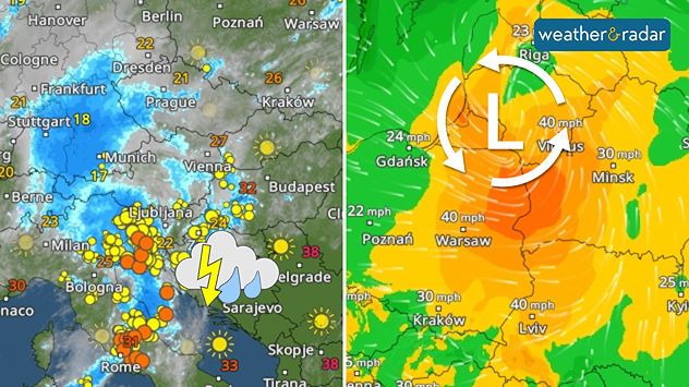
The system first brings storms around the Alps, before moving to Eastern Europe with gusting winds.

A low-pressure system is bringing heavy rain and thunderstorms from the Alps to Eastern Europe. Initially, the regions from northern Italy through Austria and Slovenia to south-eastern Germany are at risk.

There are currently thunderstorms active hereLightningRadar

By Saturday, the powerful low-pressure system will move across Poland towards the Baltic states, bringing the rain with it. Rainfall will often total between 20 and 50 mm. Locally, up to 100 mm may fall, particularly where thunderstorms break.

With such heavy rainfall, there is a risk of flooded roads, flooded basements, and landslides in the mountains. In addition, the wind is set to pick up considerably. Gusts of storm force are expected around the Alps and, later, in Poland and the Baltic states. Gusts of up to 80 miles per hour are possible.

Low brings gusting windsWindRadar
Weather & Radar editorial team

More on the topic

Preparing for the storms. What to do now. . . Thursday, 22 October 2026
Split image showing Storm Austen winds up to 65 mph near Brest and 55 mph near Plymouth, alongside fallen tree branches on a cordoned-off park path.
Thursday, 22 October 2026

What to do now

Preparing for the storms
Overnight impacts as Austen hits. Power cuts, travel issues. . . Friday, 23 October 2026
Split image showing floodwater surging beneath a railway bridge at night and a wind map with low pressure over the English Channel and 60 mph near Brest.
Friday, 23 October 2026

Power cuts, travel issues

Overnight impacts as Austen hits
Shooting stars from the Orionids peak. Mixed visibility overnight. . . Wednesday, 21 October 2026
Split image showing a bright green meteor streaking across a starry night sky beside a UK weather map with rain over Scotland and southern England.
Wednesday, 21 October 2026

Mixed visibility overnight

Shooting stars from the Orionids peak
All weather news

This might also interest you

Bright and warm conditions take hold. Spring-like outlook. . . Thursday, 23 April 2026
Split UK map showing warm temperatures up to 21 degrees in orange on the left and clear sunny conditions with temperatures from 12 to 18 degrees on the right, with sun icons across the country.
Thursday, 23 April 2026

Spring-like outlook

Bright and warm conditions take hold
A stormy week in the skies above. Your weather - Your shots. . . Sunday, 30 August 2026
Split image showing lightning branching beneath dark storm clouds above rooftops on the left and an orange-pink sunset over a calm sea on the right.
Sunday, 30 August 2026

Your weather - Your shots

A stormy week in the skies above
Long-term trends need a pinch of salt. 40 °C in July?. . . Tuesday, 30 June 2026
Temperature radar of 2022 heatwave where the all-time temperature record in the UK was set. Warning symbol overlain.
Tuesday, 30 June 2026

40 °C in July?

Long-term trends need a pinch of salt
All articles
Weather & Radar

Weather & Radar is also available on

Google Play StoreApp Store

Company

Contact us Privacy Policy Legal info Accessibility statement

Services

Uploader

Socials

facebooktwittertikToklinkList