Home
Weather London
WeatherRadar
RainfallRadar
TemperatureRadar
WindRadar
LightningRadar
Weather News
Editor's Pick
Discover the app
Weather widget
Contact us
Apps
Career
    Home / Editor's Pick /

    Stormy day in parts of the UK & Ireland

09:18
4 August 2026

Lightning potential
Stormy day in parts of the UK & Ireland

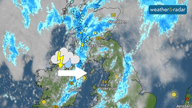
Satellite weather map of the UK and Ireland showing thunderstorms moving east from Ireland into western Scotland, highlighted by a thunderstorm icon and directional arrow. Heavy rain and lightning affect western Scotland, while temperatures range from 15°C in northeast Scotland to 24°C in northwest England and 22°C in Dublin.
Thundery outbreaks start in Ireland Tuesday morning before pushing east.

Tuesday sees heavy showers which turn thundery at times through the day, mostly through parts of Scotland after passing Ireland in the morning.

In Northern Ireland, between 20 to 30 mm of rain could fall in heavy showers lasting a couple of hours. The responsible band is moving east into the UK later in the day.

The showers can also turn thundery. North-west Ireland into Northern Ireland saw thunderstorms to start the day.

From the afternoon, the thundery potential moves into Scotland and parts of central England.

Weather warnings cover eastern Scotland in a stretch from Glasgow to Aberdeen with Wednesday warnings also issued for central to eastern Scotland. Both with low likelihoods.

Responsible for the shift in conditions is an area of low pressure situated just to the west of Scotland.

Ryan Hathaway
More on the topic
Severe weather rolls on in Europe. Heavy rain and hail. . . Thursday, 17 September 2026
Weather radar showing severe thunderstorms and frequent lightning over northern Italy.
Thursday, 17 September 2026

Heavy rain and hail

Severe weather rolls on in Europe
Low delivers days of gusty conditions. Into the weekend. . . Thursday, 17 September 2026
Wind map showing low pressure near the Faroe Islands, with winds reaching 35 mph around Aberdeen and Dublin and stronger Atlantic winds west of the UK.
Thursday, 17 September 2026

Into the weekend

Low delivers days of gusty conditions
Colourful skies and scenic clouds cover. Your weather - Your shots. . . Sunday, 20 September 2026
Split image showing a golden sunset over the sea beneath layered clouds and a pink-purple sunset reflected across calm riverside water.
Sunday, 20 September 2026

Your weather - Your shots

Colourful skies and scenic clouds cover
All weather news
This might also interest you
Historic Storm Éowyn arrives. On this day.... . . Saturday, 24 January 2026
Split image showing a person in a yellow jacket struggling against strong winds and heavy rain on a street at night on the left, and an Irish wind forecast map on the right with red and purple shading, gusts up to 75 mph, and a wind warning icon, divided by a curved white line.
Saturday, 24 January 2026

On this day...

Historic Storm Éowyn arrives
Seasonal warmth between spring thunder. Your weather - Your shots. . . Sunday, 19 April 2026
Split image showing coastal sunset with layered lenticular clouds over rooftops and palm trees on the left, and a green valley with river and hills under soft daylight on the right.
Sunday, 19 April 2026

Your weather - Your shots

Seasonal warmth between spring thunder
Flooding, gales, and heavy snow. Storm Chandra. . . Tuesday, 27 January 2026
Split image showing aerial flooding in a town with muddy water covering roads on the left, and a rural road on the right blocked by heavy snowfall with vans stopped and a person walking in snow.
Tuesday, 27 January 2026

Storm Chandra

Flooding, gales, and heavy snow
All articles
Weather & Radar

Weather & Radar is also available on

Google Play StoreApp Store

Company

Contact us Privacy Policy Legal info Accessibility statement

Services

Uploader

Socials

facebooktwittertikToklinkList