Home
Weather London
WeatherRadar
RainfallRadar
TemperatureRadar
WindRadar
LightningRadar
Weather News
Editor's Pick
Discover the app
Weather widget
Contact us
Apps
Career
    Home / Editor's Pick /

    Storm Therese - Heavy rainfall on the Canary Islands

09:47
20 March 2026

Storm Therese
Heavy rainfall on the Canary Islands

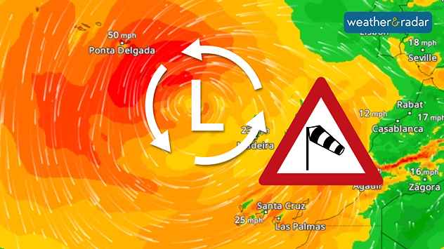
WindRadar: A storm system has moved far south and is currently sweeping from the Azores to Morocco.

A powerful low-pressure system named Therese is currently causing very stormy weather in the Canary Islands. Due to the threat of severe weather, all schools and nurseries will be closed on Friday.

The authorities have urged people to work from home where possible. There are also transport restrictions: several roads have been closed on La Palma, and flights have been cancelled or diverted. Ferry services have also been suspended.

Annual rainfall over a three-day period

A strong south-westerly wind not only causes waves several metres high, but also intensifies the rainfall. The western Canary Islands in particular are quite mountainous, which leads to a wind-shadow effect.

On the south-western side of La Palma, Tenerife or Gran Canaria, rainfall of between 200 and 400 mm of rainfall is possible over the weekend. That is more than the average annual rainfall and could lead to flash floods and landslides.

LocationRainfall to date (mm)
Vega de San Mateo (Gran Canaria)55
San Bartolomé de Tirajana (Gran Canaria)48
La Orotava (Tenerife)41
Tejeda (Gran Canaria)36
Santa Cruz de Tenerife (Tenerife)15
Check conditions at the CanariesWeatherRadar
Michael Krucker
with material from dpa
More on the topic
Heavier rainfall over the week for some. Ireland & Scotland. . . Tuesday, 28 July 2026
Split image showing a Europe rainfall accumulation forecast map on the left with the highest totals across the UK, Ireland, and Scandinavia, and a satellite weather map on the right with a broad band of rain stretching across Ireland, Scotland, and northern Britain, highlighted by a rain cloud icon.
Tuesday, 28 July 2026

Ireland & Scotland

Heavier rainfall over the week for some
Clouds return to capture the scene. Your weather - Your shots. . . Sunday, 26 July 2026
Waxing crescent Moon above vivid pink and magenta sunset clouds, with silhouetted trees along the horizon beneath a deepening blue twilight sky.
Sunday, 26 July 2026

Your weather - Your shots

Clouds return to capture the scene
Catastrophic forest fires in Europe. Thousands evacuated. . . Monday, 27 July 2026
A composite image showing a temperature map of south-western Europe and a drone shot of a forest fire near Cap Ferret. A warning symbol featuring a flame indicates the increased risk of forest fires.
Monday, 27 July 2026

Thousands evacuated

Catastrophic forest fires in Europe
All weather news
This might also interest you
New records for England and Wales. Broken again tomorrow?. . . Thursday, 25 June 2026
Temperature map of southwest Britain on 25.06 showing extreme heat across southern Wales and southwest England, with Bute Park in Cardiff highlighted at 34.2°C and Yeovilton at 36.4°C amid widespread deep red heat zones.
Thursday, 25 June 2026

Broken again tomorrow?

New records for England and Wales
Flooding, gales, and heavy snow. Storm Chandra. . . Tuesday, 27 January 2026
Split image showing aerial flooding in a town with muddy water covering roads on the left, and a rural road on the right blocked by heavy snowfall with vans stopped and a person walking in snow.
Tuesday, 27 January 2026

Storm Chandra

Flooding, gales, and heavy snow
Storm Chandra makes impact. Severe gales & heavy rain. . . Tuesday, 27 January 2026
Split image showing strong winds over the UK on a forecast map and widespread rain and snow on a weather radar map.
Tuesday, 27 January 2026

Severe gales & heavy rain

Storm Chandra makes impact
All articles
Weather & Radar

Weather & Radar is also available on

Google Play StoreApp Store

Company

Contact us Privacy Policy Legal info Accessibility statement

Services

Uploader

Socials

facebooktwittertikToklinkList