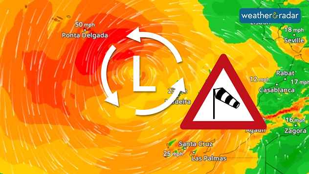
Home
Weather London
WeatherRadar
RainfallRadar
TemperatureRadar
WindRadar
LightningRadar
Weather News
Editor's Pick
Discover the app
Weather widget
Contact us
Apps
Career
Home / Editor's Pick /

Storm Therese - Heavy rainfall on the Canary Islands

09:47
20 March 2026

Storm Therese
Heavy rainfall on the Canary Islands

WindRadar: A storm system has moved far south and is currently sweeping from the Azores to Morocco.

A powerful low-pressure system named Therese is currently causing very stormy weather in the Canary Islands. Due to the threat of severe weather, all schools and nurseries will be closed on Friday.

The authorities have urged people to work from home where possible. There are also transport restrictions: several roads have been closed on La Palma, and flights have been cancelled or diverted. Ferry services have also been suspended.

Annual rainfall over a three-day period

A strong south-westerly wind not only causes waves several metres high, but also intensifies the rainfall. The western Canary Islands in particular are quite mountainous, which leads to a wind-shadow effect.

On the south-western side of La Palma, Tenerife or Gran Canaria, rainfall of between 200 and 400 mm of rainfall is possible over the weekend. That is more than the average annual rainfall and could lead to flash floods and landslides.

LocationRainfall to date (mm)
Vega de San Mateo (Gran Canaria)55
San Bartolomé de Tirajana (Gran Canaria)48
La Orotava (Tenerife)41
Tejeda (Gran Canaria)36
Santa Cruz de Tenerife (Tenerife)15
Check conditions at the CanariesWeatherRadar
Michael Krucker
with material from dpa
More on the topic
Split weather graphic showing a low-pressure system with tight isobars over the UK on the left and a wind map on the right with strong gusts up to 90 mph, plus a windsock warning icon.
Thursday, 2 April 2026

Gales and blizzards

Storm Dave disrupts Easter weekend
On the left, the weather radar for Italy showing heavy rain; on the right, a flooded road
Thursday, 2 April 2026

Severe weather in Italy

Flooding and heavy snowfall
Split weather graphic showing breezy conditions across the UK and Ireland on the left with winds around 25–30 mph, and a rain band moving east across Ireland into Britain on the right.
Tuesday, 31 March 2026

Unsettled midweek

Wet & windy Wednesday for some
All weather news
This might also interest you
Split image showing strong winds over the UK on a forecast map and widespread rain and snow on a weather radar map.
Tuesday, 27 January 2026

Severe gales & heavy rain

Storm Chandra makes impact
Split weather map showing UK wind speeds in orange-red shades up to 40 mph on the left and warning levels in green-yellow on the right, with a central wind warning sign.
Wednesday, 22 October 2025

Warnings active

Storm Benjamin impacts the UK
UK temperature map dated 14.02 showing widespread subzero values in blue shading, with readings such as −4 in Glasgow, −3 in Dublin, and −2 in London, alongside a blue thermometer icon.
Friday, 13 February 2026

Icy conditions

A frozen start to the weekend
All articles
Weather & Radar

Weather & Radar is also available on

Google Play StoreApp Store

Company

Contact us Privacy Policy Legal info Accessibility statement

Services

Uploader

Socials

facebooktwittertikToklinkList