Home
Weather London
WeatherRadar
RainfallRadar
TemperatureRadar
WindRadar
LightningRadar
Weather News
Editor's Pick
Discover the app
Weather widget
Contact us
Apps
Career
    Home / Editor's Pick /

    Storm Goretti moving in – wind, rain, and snow

09:30
7 January 2026

Wind, rain, and snow
Storm Goretti moving in

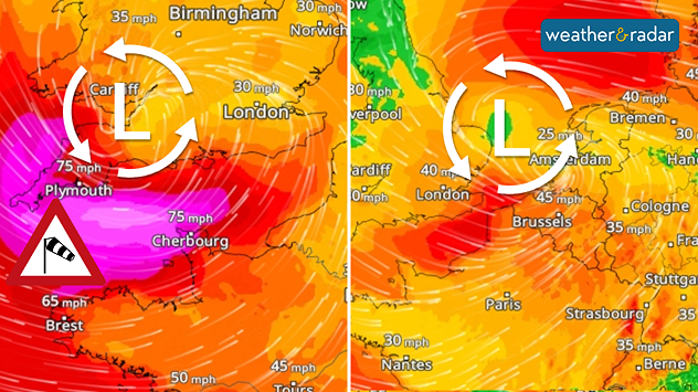
WindRadar: On Thursday (left), the storm risk rests on the Atlantic coasts, by Friday (right), strong winds Central Europe.

A storm front will reach the UK, Ireland, and France on Thursday, before moving east on Friday into Europe, bringing strong winds, snow, and rain.

Gusts of up to 75 mph are expected in the English Channel, on the south-west coast of England and in Brittany, France. Strong to stormy winds will also blow inland, particularly on Friday, from northern France to the North Sea and Baltic Sea.

Rain and snowfall

The low pressure system is bringing mild Atlantic air in its wake, so it will mostly rain with temperatures above zero. At the same time, frosty air from Scandinavia will linger, resulting in snowfall. Combined with the wind, snow drifts are possible.

At the weekend, icy polar air will flow into Central Europe at the rear of the low-pressure system. This will cause the snow line to drop again in regions that had previously been mild.

Mild air arrivingTemperatureRadar Europe
Tommy Kühnlein
More on the topic
Forest fires are getting out of control. Spain and France. . . Saturday, 25 July 2026
A split-screen image featuring a photograph and a weather map. On the left, thick, dark-grey smoke rises from several fire sites in a wooded coastal area; a calm stretch of water can be seen in the foreground. On the right, a weather map shows south-western France and northern Spain. A red arrow points from the Atlantic towards the French Atlantic coast, symbolising an onshore wind. Sunny weather is forecast for Bordeaux at around 20 degrees, and Bilbao is also expected to be sunny at around 27 degrees. A large warning sign with a flame symbol indicates an increased risk of forest fires.
Saturday, 25 July 2026

Spain and France

Forest fires are getting out of control
Heat becoming a bigger factor in drought. New study. . . Thursday, 23 July 2026
A hand holds dry, dusty earth above a parched field. The ground is cracked and covered with plant debris – a sign of prolonged drought.
Thursday, 23 July 2026

New study

Heat becoming a bigger factor in drought
Fourth heatwave of the year. Peaking Wednesday. . . Tuesday, 28 July 2026
Temperature map of England and Wales on Wednesday 29.07 showing widespread hot conditions, with temperatures reaching 33°C near Cambridge, 32°C around London, Norwich, and Southend-on-Sea, and a large heat warning symbol highlighting elevated heat risk.
Tuesday, 28 July 2026

Peaking Wednesday

Fourth heatwave of the year
All weather news
This might also interest you
Long-term trends need a pinch of salt. 40 °C in July?. . . Tuesday, 30 June 2026
Temperature radar of 2022 heatwave where the all-time temperature record in the UK was set. Warning symbol overlain.
Tuesday, 30 June 2026

40 °C in July?

Long-term trends need a pinch of salt
A frozen start to the weekend. Icy conditions. . . Friday, 13 February 2026
UK temperature map dated 14.02 showing widespread subzero values in blue shading, with readings such as −4 in Glasgow, −3 in Dublin, and −2 in London, alongside a blue thermometer icon.
Friday, 13 February 2026

Icy conditions

A frozen start to the weekend
New records for England and Wales. Broken again tomorrow?. . . Thursday, 25 June 2026
Temperature map of southwest Britain on 25.06 showing extreme heat across southern Wales and southwest England, with Bute Park in Cardiff highlighted at 34.2°C and Yeovilton at 36.4°C amid widespread deep red heat zones.
Thursday, 25 June 2026

Broken again tomorrow?

New records for England and Wales
All articles
Weather & Radar

Weather & Radar is also available on

Google Play StoreApp Store

Company

Contact us Privacy Policy Legal info Accessibility statement

Services

Uploader

Socials

facebooktwittertikToklinkList