Home
Weather London
WeatherRadar
RainfallRadar
TemperatureRadar
WindRadar
LightningRadar
Weather News
Editor's Pick
Discover the app
Weather widget
Contact us
Apps
Career
    Home / Editor's Pick /

    Storm Claudia - Heavy rain likely to bring disruption

09:00
13 November 2025

Storm Claudia
Heavy rain likely to bring disruption

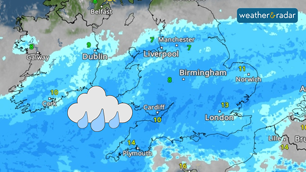
Weather radar showing widespread heavy rain across Wales, England, and south-east Ireland.
Friday looks to be a complete washout for many.

Continuous heavy rainfall on Friday is likely to bring widespread disruption to end the week, with flooding expected and warnings issued.

The large area of rain moves in on Thursday evening, and sits almost stationary throughout Friday, not easing until well into Saturday.

Flood risk

There are over 100 flood alerts active across England, primarily focused around the Midlands.

As a result, expect poor visibility on the roads, and flooding in those areas that sit under the rain band. Impacts will be particularly felt in south-east Wales, where up to 150 mm of rain is expected over higher grounds.

It won't just be the rain dampening the day, strong gusting winds of up to 60 mph (97 km/h) will arrive Friday evening in eastern Ireland and western Wales.

More widely between 35 (55) - 50 mph (80 km/h) across the UK and Ireland, these winds will be felt in Scotland too where the heavy rain will not reach.

These conditions are due to the influence of Storm Claudia, named by the Spanish Met Office, which is expected to deliver up to 200 mm of rainfall in Portugal and western Spain by the weekend.

Keep an eye on conditionsWeatherRadar
Ryan Hathaway
More on the topic
Hurricane Lowell threatens Hawaii. Gales and flash floods. . . Tuesday, 8 September 2026
WindRadar showing Hurricane Lowell north-west of Hawaii and its well-defined storm centre.
Tuesday, 8 September 2026

Gales and flash floods

Hurricane Lowell threatens Hawaii
Severe weather in southern Europe. Thunderstorms & heavy rain. . . Wednesday, 9 September 2026
On the left, dark storm clouds over a coastline. On the right, a weather map shows thunderstorms over the western Mediterranean, with warning symbols for tornadoes, storms and hail.
Wednesday, 9 September 2026

Thunderstorms & heavy rain

Severe weather in southern Europe
Hottest summer on record for Ireland. Beating 2025's record. . . Thursday, 3 September 2026
Temperature map of Ireland showing 29°C in Dublin, 26°C in Cork, 24°C in Belfast, and 23°C in Galway, with a red thermometer icon.
Thursday, 3 September 2026

Beating 2025's record

Hottest summer on record for Ireland
All weather news
This might also interest you
Storm Chandra makes impact. Severe gales & heavy rain. . . Tuesday, 27 January 2026
Split image showing strong winds over the UK on a forecast map and widespread rain and snow on a weather radar map.
Tuesday, 27 January 2026

Severe gales & heavy rain

Storm Chandra makes impact
A stormy week in the skies above. Your weather - Your shots. . . Sunday, 30 August 2026
Split image showing lightning branching beneath dark storm clouds above rooftops on the left and an orange-pink sunset over a calm sea on the right.
Sunday, 30 August 2026

Your weather - Your shots

A stormy week in the skies above
Bright and warm conditions take hold. Spring-like outlook. . . Thursday, 23 April 2026
Split UK map showing warm temperatures up to 21 degrees in orange on the left and clear sunny conditions with temperatures from 12 to 18 degrees on the right, with sun icons across the country.
Thursday, 23 April 2026

Spring-like outlook

Bright and warm conditions take hold
All articles
Weather & Radar

Weather & Radar is also available on

Google Play StoreApp Store

Company

Contact us Privacy Policy Legal info Accessibility statement

Services

Uploader

Socials

facebooktwittertikToklinkList