Home
Weather London
WeatherRadar
RainfallRadar
TemperatureRadar
WindRadar
LightningRadar
Weather News
Editor's Pick
Discover the app
Weather widget
Contact us
Apps
Career
    Home / Editor's Pick /

    Storm chaser's blog: On the front lines of extreme weather

08:00
20 August 2025

Storm chaser's blog
On the front lines of extreme weather

during a severe weather outbreak
© Jonathan Petramala

Seasoned journalist Jonathan Petramala specialises in extreme weather, and, reporting from the field for Weather & Radar, facing down intense storms is part of the job.

Jonathan has been a professional journalist for over 20 years and shifted his focus to extreme weather in 2018, intercepting his first major hurricane, Hurricane Florence, later that year.

We love weather!

Last year, in the miniseries 'Storm chaser's Blog', Weather & Radar's meteorologists shared their wildest experiences chasing storms. As avid photographers and storm chasers, their passion for weather is a lifestyle that reaches far beyond work.

“Documenting these events is crucial for fostering empathy and mobilising aid. My coverage often directly leads to volunteer and support efforts, making the risks worthwhile,” explains Petramala.

One of Jonathan's proudest moments was during Hurricane Beryl in Carriacou in June 2024. He and his colleague, Brandon Clement, were the only journalists on the island and provided critical communication and insight into the devastation.

Storm chasing: Too close for comfortread more

Their reports helped coordinate emergency responses and facilitated rapid aid delivery, including bringing Starlink terminals to restore communication.

Recommended external content from YouTube

We need your consent to show content from YouTube. You can withdraw your consent at any time.

I agree that content from YouTube will be displayed to me.
Privacy Policy

While extensive preparation minimises fear, there are still dangers. During Hurricane Beryl, the roof of their shelter was torn off, exposing them to flying debris and gusts over 140 mph.

Staying calm, they relocated to safety, ensuring they could continue their vital work.

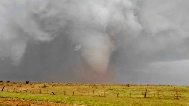
Another adrenaline-filled moment occurred on May 3, 2024, when an erratically moving tornado and lack of radar service put Jonathan in a tight spot, relying on visual cues and last-minute decisions to steer clear of the tornado.

USA - Alone with the supercellread also
Weather & Radar editorial team
More on the topic
Severe weather hits Mallorca and Italy. Severe thunderstorms. . . Thursday, 10 September 2026
Numerous thunderstorms are sweeping across La Palma. The many lightning symbols on the radar and lightning map show that there is heavy lightning activity across large parts of the island. The thunderstorms are striking particularly in the island’s interior and in the south. On the right, you can see the aftermath: a large fallen tree has buried a car beneath it. Emergency services are clearing up the damage. So, along with the thunderstorms, not only heavy rain but also gusts of wind can become a problem.
Thursday, 10 September 2026

Severe thunderstorms

Severe weather hits Mallorca and Italy
Warm waters raise severe weather risk. Mediterranean bathtub. . . Friday, 4 September 2026
Left: Map showing water temperatures in the Mediterranean; Right: Dark clouds over a stretch of Mediterranean coastline. A bolt of lightning strikes and a curtain of rain can be seen.
Friday, 4 September 2026

Mediterranean bathtub

Warm waters raise severe weather risk
A marked change in the weather. Cold front heading south. . . Monday, 7 September 2026
Map of Europe showing a cold front stretching from Scandinavia to Spain. Thunderstorms are shown in southern and central Europe.
Monday, 7 September 2026

Cold front heading south

A marked change in the weather
All weather news
This might also interest you
A frozen start to the weekend. Icy conditions. . . Friday, 13 February 2026
UK temperature map dated 14.02 showing widespread subzero values in blue shading, with readings such as −4 in Glasgow, −3 in Dublin, and −2 in London, alongside a blue thermometer icon.
Friday, 13 February 2026

Icy conditions

A frozen start to the weekend
Historic Storm Éowyn arrives. On this day.... . . Saturday, 24 January 2026
Split image showing a person in a yellow jacket struggling against strong winds and heavy rain on a street at night on the left, and an Irish wind forecast map on the right with red and purple shading, gusts up to 75 mph, and a wind warning icon, divided by a curved white line.
Saturday, 24 January 2026

On this day...

Historic Storm Éowyn arrives
Super Typhoon Bavi threatens Taiwan. Up to 1,000 mm of rain. . . Wednesday, 8 July 2026
The image shows an intense tropical cyclone over the western Pacific, east of Taiwan and the Philippines. The centre of the system is depicted as a light purple and white vortex with a clearly visible eye, surrounded by a ring of red and orange areas indicating the strongest wind speeds. A white arrow marks the typhoon’s predicted track towards the north-west, in the direction of Taiwan. To the west of the storm lie the Philippines, with the cities of Manila and Cebu; to the north of these lies Taiwan, with Taipei. Further west, the Chinese coast, including Hong Kong, and parts of Vietnam can be seen. The coloured wind map shows predominantly green areas outside the storm’s core, indicating significantly weaker winds. White streamlines illustrate the typhoon’s anti-clockwise circulation in the Northern Hemisphere. The highest wind speeds are concentrated around the eye of the cyclone.
Wednesday, 8 July 2026

Up to 1,000 mm of rain

Super Typhoon Bavi threatens Taiwan
All articles
Weather & Radar

Weather & Radar is also available on

Google Play StoreApp Store

Company

Contact us Privacy Policy Legal info Accessibility statement

Services

Uploader

Socials

facebooktwittertikToklinkList