Home
Weather London
WeatherRadar
RainfallRadar
TemperatureRadar
WindRadar
LightningRadar
Weather News
Editor's Pick
Discover the app
Weather widget
Contact us
Apps
Career
    Home / Editor's Pick /

    Storm chaser's blog: On the front lines of extreme weather

08:00
20 August 2025

Storm chaser's blog
On the front lines of extreme weather

during a severe weather outbreak
© Jonathan Petramala

Seasoned journalist Jonathan Petramala specialises in extreme weather, and, reporting from the field for Weather & Radar, facing down intense storms is part of the job.

Jonathan has been a professional journalist for over 20 years and shifted his focus to extreme weather in 2018, intercepting his first major hurricane, Hurricane Florence, later that year.

We love weather!

Last year, in the miniseries 'Storm chaser's Blog', Weather & Radar's meteorologists shared their wildest experiences chasing storms. As avid photographers and storm chasers, their passion for weather is a lifestyle that reaches far beyond work.

“Documenting these events is crucial for fostering empathy and mobilising aid. My coverage often directly leads to volunteer and support efforts, making the risks worthwhile,” explains Petramala.

One of Jonathan's proudest moments was during Hurricane Beryl in Carriacou in June 2024. He and his colleague, Brandon Clement, were the only journalists on the island and provided critical communication and insight into the devastation.

Storm chasing: Too close for comfortread more

Their reports helped coordinate emergency responses and facilitated rapid aid delivery, including bringing Starlink terminals to restore communication.

Recommended external content from YouTube

We need your consent to show content from YouTube. You can withdraw your consent at any time.

I agree that content from YouTube will be displayed to me.
Privacy Policy

While extensive preparation minimises fear, there are still dangers. During Hurricane Beryl, the roof of their shelter was torn off, exposing them to flying debris and gusts over 140 mph.

Staying calm, they relocated to safety, ensuring they could continue their vital work.

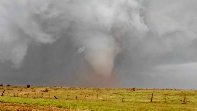
Another adrenaline-filled moment occurred on May 3, 2024, when an erratically moving tornado and lack of radar service put Jonathan in a tight spot, relying on visual cues and last-minute decisions to steer clear of the tornado.

USA - Alone with the supercellread also
Weather & Radar editorial team
More on the topic
UV levels peak with the heat today. Latest heatwave. . . Wednesday, 29 July 2026
Split graphic showing a temperature map of England and eastern Ireland with temperatures reaching 33°C near London, 32°C in Norwich, and 29°C around Birmingham on the left, alongside a person applying sunscreen with a UV icon on the right.
Wednesday, 29 July 2026

Latest heatwave

UV levels peak with the heat today
Clouds return to capture the scene. Your weather - Your shots. . . Sunday, 26 July 2026
Waxing crescent Moon above vivid pink and magenta sunset clouds, with silhouetted trees along the horizon beneath a deepening blue twilight sky.
Sunday, 26 July 2026

Your weather - Your shots

Clouds return to capture the scene
Drought for North Wales and Upper Severn. 2% of average rainfall. . . Thursday, 23 July 2026
Split image showing a July rainfall anomaly map of Europe on the left with below-average rainfall across the UK, Ireland, and much of western and central Europe, and an active moorland wildfire on the right producing flames and thick smoke near homes.
Thursday, 23 July 2026

2% of average rainfall

Drought for North Wales and Upper Severn
All weather news
This might also interest you
Seasonal warmth between spring thunder. Your weather - Your shots. . . Sunday, 19 April 2026
Split image showing coastal sunset with layered lenticular clouds over rooftops and palm trees on the left, and a green valley with river and hills under soft daylight on the right.
Sunday, 19 April 2026

Your weather - Your shots

Seasonal warmth between spring thunder
Flooding, gales, and heavy snow. Storm Chandra. . . Tuesday, 27 January 2026
Split image showing aerial flooding in a town with muddy water covering roads on the left, and a rural road on the right blocked by heavy snowfall with vans stopped and a person walking in snow.
Tuesday, 27 January 2026

Storm Chandra

Flooding, gales, and heavy snow
New records for England and Wales. Broken again tomorrow?. . . Thursday, 25 June 2026
Temperature map of southwest Britain on 25.06 showing extreme heat across southern Wales and southwest England, with Bute Park in Cardiff highlighted at 34.2°C and Yeovilton at 36.4°C amid widespread deep red heat zones.
Thursday, 25 June 2026

Broken again tomorrow?

New records for England and Wales
All articles
Weather & Radar

Weather & Radar is also available on

Google Play StoreApp Store

Company

Contact us Privacy Policy Legal info Accessibility statement

Services

Uploader

Socials

facebooktwittertikToklinkList