Home
Weather London
WeatherRadar
RainfallRadar
TemperatureRadar
WindRadar
LightningRadar
Weather News
Editor's Pick
Discover the app
Weather widget
Contact us
Apps
Career
    Home / Weather News /

    Storm Chandra - Flooding, gales, and heavy snow

13:49
27 January 2026

Storm Chandra
Flooding, gales, and heavy snow

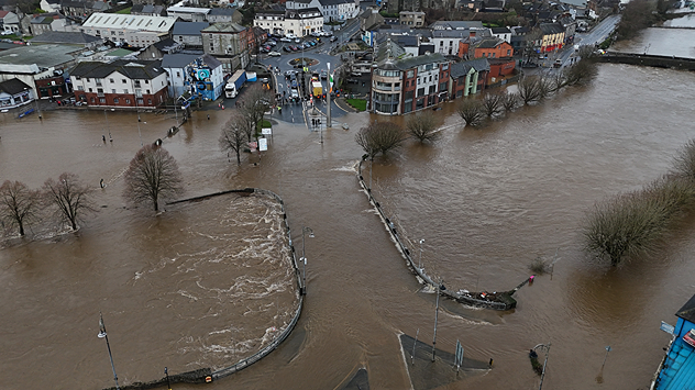
Aerial view of a town with rivers overflowed, brown floodwater covering roads, parks, and footpaths, surrounding buildings and trees.
The River Slaney burst its banks Tuesday morning, flooding Enniscorthy, Co. Wexford. - © picture alliance

As Storm Chandra passes through, surface flooding and rivers bursting their banks are being reported in southern Ireland and the UK, while it is heavy snow disrupting things further north.

In Co. Wexford, the River Slaney burst its banks in Enniscorthy, flooding the riverbanks, roads, and some vehicles. In York, the River Ouse has also overflown.

Elsewhere, the torrential rain has resulted in flooded roads impacting travel, with Devon and Somerset firefighters reporting that they have rescued people from 25 vehicles.

Snow is also an issue in Durham and further north in Scotland, particularly over higher ground.

Snowploughs have been deployed to ease road conditions, though the icy pavements still pose a risk to those on foot.

Meanwhile, new weather warnings for ice have been issued for Wednesday. These cover southern Scotland, central to eastern Wales, much of England (outside of the south-west), and Northern Ireland.

Ryan Hathaway
More on the topic
Europe's summer set to to break records. Extreme heat and drought. . . Tuesday, 11 August 2026
Split image showing a European heat map with temperatures reaching 39°C in France and Spain on the left, and a severely depleted river with exposed sandy banks beneath a bridge on the right.
Tuesday, 11 August 2026

Extreme heat and drought

Europe's summer set to to break records
Cooler nights on the horizon. For parts of Europe. . . Thursday, 6 August 2026
Temperature Radar showing the night-time lows in Central Europe. Cooler air is reaching the west and north in particular, whilst the south-east remains significantly warmer.
Thursday, 6 August 2026

For parts of Europe

Cooler nights on the horizon
The Perseids reach their peak. Shooting stars overhead. . . Tuesday, 11 August 2026
Shooting stars in the night sky
Tuesday, 11 August 2026

Shooting stars overhead

The Perseids reach their peak
All weather news
This might also interest you
Historic Storm Éowyn arrives. On this day.... . . Saturday, 24 January 2026
Split image showing a person in a yellow jacket struggling against strong winds and heavy rain on a street at night on the left, and an Irish wind forecast map on the right with red and purple shading, gusts up to 75 mph, and a wind warning icon, divided by a curved white line.
Saturday, 24 January 2026

On this day...

Historic Storm Éowyn arrives
A frozen start to the weekend. Icy conditions. . . Friday, 13 February 2026
UK temperature map dated 14.02 showing widespread subzero values in blue shading, with readings such as −4 in Glasgow, −3 in Dublin, and −2 in London, alongside a blue thermometer icon.
Friday, 13 February 2026

Icy conditions

A frozen start to the weekend
Seasonal warmth between spring thunder. Your weather - Your shots. . . Sunday, 19 April 2026
Split image showing coastal sunset with layered lenticular clouds over rooftops and palm trees on the left, and a green valley with river and hills under soft daylight on the right.
Sunday, 19 April 2026

Your weather - Your shots

Seasonal warmth between spring thunder
All articles
Weather & Radar

Weather & Radar is also available on

Google Play StoreApp Store

Company

Contact us Privacy Policy Legal info Accessibility statement

Services

Uploader

Socials

facebooktwittertikToklinkList