Home
Weather London
WeatherRadar
RainfallRadar
TemperatureRadar
WindRadar
LightningRadar
Weather News
Editor's Pick
Discover the app
Weather widget
Contact us
Apps
Career
    Home / Editor's Pick /

    Storm Boelo named

12:19
22 October 2026

Weekend impacts
Storm Boelo named

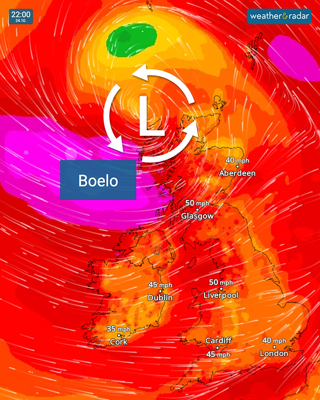
Wind forecast at 22:00 on 24.10 showing Storm Boelo northwest of Scotland, with winds of 50 mph near Glasgow and Liverpool and 45 mph near Dublin.
Storm Boelo moves in this weekend.

Hot on the tail of Austen, the second named storm of the season, Boelo, has been named.

This system impacts the north of the UK and Ireland from Saturday. Boelo is being fuelled by an active jet stream as it moves east, reaching the UK on Saturday.

Gales reaching up to 80 mph are possible in exposed coastal areas in the west of Scotland. In Northern Ireland, gusts of up to 60 mph are expected, reaching up to 75 mph in exposed areas.

Heavy rain will spread eastwards throughout the day.

Check back for more details on Storm Boelo, and Storm Austen, which arrives Thursday evening.

Ryan Hathaway

More on the topic

Further fog disruption expected. Growing dense overnight. . . Monday, 9 November 2026
Weather map showing widespread fog across the English Midlands, with a red fog warning symbol near Nottingham and temperatures of 4–6°C.
Monday, 9 November 2026

Growing dense overnight

Further fog disruption expected
Gloomy evening with a few spots of rain. Bonfire Night. . . Thursday, 5 November 2026
Split image showing a cloudy UK weather map with temperatures of 8–9°C alongside colourful fireworks bursting through smoke in the night sky.
Thursday, 5 November 2026

Bonfire Night

Gloomy evening with a few spots of rain
Front brings showers from the south-west. Brolly needed for some. . . Tuesday, 10 November 2026
Weather map showing blue rain bands across southern Ireland, Wales and southwest England, with a northeastward arrow and temperatures of 7–10°C.
Tuesday, 10 November 2026

Brolly needed for some

Front brings showers from the south-west
All weather news

This might also interest you

Seasonal warmth between spring thunder. Your weather - Your shots. . . Sunday, 19 April 2026
Split image showing coastal sunset with layered lenticular clouds over rooftops and palm trees on the left, and a green valley with river and hills under soft daylight on the right.
Sunday, 19 April 2026

Your weather - Your shots

Seasonal warmth between spring thunder
Bright and warm conditions take hold. Spring-like outlook. . . Thursday, 23 April 2026
Split UK map showing warm temperatures up to 21 degrees in orange on the left and clear sunny conditions with temperatures from 12 to 18 degrees on the right, with sun icons across the country.
Thursday, 23 April 2026

Spring-like outlook

Bright and warm conditions take hold
Storm Chandra makes impact. Severe gales & heavy rain. . . Tuesday, 27 January 2026
Split image showing strong winds over the UK on a forecast map and widespread rain and snow on a weather radar map.
Tuesday, 27 January 2026

Severe gales & heavy rain

Storm Chandra makes impact
All articles
Weather & Radar

Weather & Radar is also available on

Google Play StoreApp Store

Company

Contact us Privacy Policy Legal info Accessibility statement

Services

Uploader

Socials

facebooktwittertikToklinkList