Home
Weather London
WeatherRadar
RainfallRadar
TemperatureRadar
WindRadar
LightningRadar
Weather News
Editor's Pick
Discover the app
Weather widget
Contact us
Apps
Career
    Home / Weather News /

    Storm and rain – Turbulent weather in the Canary Islands

10:00
12 December 2025

Storm and rain
Turbulent weather in the Canary Islands

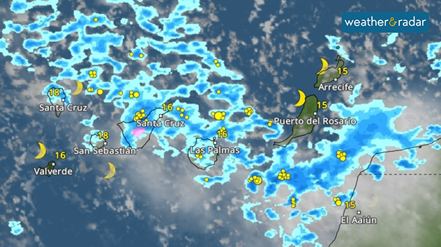
The weather radar forecast shows many thunderstorms over the islands.

Stormy weather is on the way for the Canary Islands. Low pressure systems with strong gusts of wind, heavy showers and thunderstorms are reaching the islands. Madeira and parts of Morocco are also affected.

The wind will pick up significantly during the day, reaching speeds of 80 kilometres per hour. During showers and thunderstorms, gusts of up to 100 kilometres per hour are also possible.

In addition, the wind is whipping up the sea considerably, and waves over 5 metres high are hitting the coast. There is a danger to life near the water.

The turbulent weather conditions will remain largely unchanged on Saturday. It will only become noticeably calmer again on Sunday.

Follow showers and thunderstorms liveWeather radar
Dennis Oswald
More on the topic
Forest fires are getting out of control. Spain and France. . . Saturday, 25 July 2026
A split-screen image featuring a photograph and a weather map. On the left, thick, dark-grey smoke rises from several fire sites in a wooded coastal area; a calm stretch of water can be seen in the foreground. On the right, a weather map shows south-western France and northern Spain. A red arrow points from the Atlantic towards the French Atlantic coast, symbolising an onshore wind. Sunny weather is forecast for Bordeaux at around 20 degrees, and Bilbao is also expected to be sunny at around 27 degrees. A large warning sign with a flame symbol indicates an increased risk of forest fires.
Saturday, 25 July 2026

Spain and France

Forest fires are getting out of control
Heavier rainfall over the week for some. Ireland & Scotland. . . Tuesday, 28 July 2026
Split image showing a Europe rainfall accumulation forecast map on the left with the highest totals across the UK, Ireland, and Scandinavia, and a satellite weather map on the right with a broad band of rain stretching across Ireland, Scotland, and northern Britain, highlighted by a rain cloud icon.
Tuesday, 28 July 2026

Ireland & Scotland

Heavier rainfall over the week for some
Typhoon warning for China. Up to 500 mm of rain. . . Friday, 24 July 2026
Weather map of the southern Chinese coast and Taiwan showing a powerful tropical cyclone. The eye of the storm is located near the coastal city of Shantou in the Chinese province of Guangdong. Around the centre, intense shades of red, pink and violet indicate gale-force winds, whilst a large orange wind field extends as far as the west coast of Taiwan. An overlaid windsack warning sign indicates dangerous storm winds. Cities such as Hong Kong, Guangzhou, Xiamen, Taipei and Taichung are shown, as are wind speeds and white flow lines illustrating the cyclonic air circulation.
Friday, 24 July 2026

Up to 500 mm of rain

Typhoon warning for China
All weather news
This might also interest you
Long-term trends need a pinch of salt. 40 °C in July?. . . Tuesday, 30 June 2026
Temperature radar of 2022 heatwave where the all-time temperature record in the UK was set. Warning symbol overlain.
Tuesday, 30 June 2026

40 °C in July?

Long-term trends need a pinch of salt
Historic Storm Éowyn arrives. On this day.... . . Saturday, 24 January 2026
Split image showing a person in a yellow jacket struggling against strong winds and heavy rain on a street at night on the left, and an Irish wind forecast map on the right with red and purple shading, gusts up to 75 mph, and a wind warning icon, divided by a curved white line.
Saturday, 24 January 2026

On this day...

Historic Storm Éowyn arrives
New records for England and Wales. Broken again tomorrow?. . . Thursday, 25 June 2026
Temperature map of southwest Britain on 25.06 showing extreme heat across southern Wales and southwest England, with Bute Park in Cardiff highlighted at 34.2°C and Yeovilton at 36.4°C amid widespread deep red heat zones.
Thursday, 25 June 2026

Broken again tomorrow?

New records for England and Wales
All articles
Weather & Radar

Weather & Radar is also available on

Google Play StoreApp Store

Company

Contact us Privacy Policy Legal info Accessibility statement

Services

Uploader

Socials

facebooktwittertikToklinkList