Home
Weather London
WeatherRadar
RainfallRadar
TemperatureRadar
WindRadar
LightningRadar
Weather News
Editor's Pick
Discover the app
Weather widget
Contact us
Apps
Career
    Home / Weather News /

    Storm and rain – Turbulent weather in the Canary Islands

10:00
12 December 2025

Storm and rain
Turbulent weather in the Canary Islands

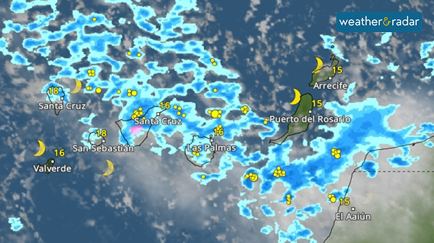
The weather radar forecast shows many thunderstorms over the islands.

Stormy weather is on the way for the Canary Islands. Low pressure systems with strong gusts of wind, heavy showers and thunderstorms are reaching the islands. Madeira and parts of Morocco are also affected.

The wind will pick up significantly during the day, reaching speeds of 80 kilometres per hour. During showers and thunderstorms, gusts of up to 100 kilometres per hour are also possible.

In addition, the wind is whipping up the sea considerably, and waves over 5 metres high are hitting the coast. There is a danger to life near the water.

The turbulent weather conditions will remain largely unchanged on Saturday. It will only become noticeably calmer again on Sunday.

Follow showers and thunderstorms liveWeather radar
Dennis Oswald
More on the topic
On the left is the temperature radar, showing high temperatures across Western Europe. On the right is the weather radar, showing a high-pressure system.
Tuesday, 26 May 2026

Summer weather in spring

Heatwave sets new records in Europe too
Nighttime marina with sailboats and glowing harbor lights beneath electric-blue noctilucent clouds stretching across the dark twilight sky.
Saturday, 23 May 2026

A silvery haze in the sky

The season of the luminous night clouds
Split image showing a bright rainbow above a residential street on the left and a dramatic ocean sunrise with glowing clouds and reflections on the sea on the right.
Sunday, 24 May 2026

Your weather - Your shots

From unsettled to warm and toasty
All weather news
This might also interest you
Split weather map showing UK wind speeds in orange-red shades up to 40 mph on the left and warning levels in green-yellow on the right, with a central wind warning sign.
Wednesday, 22 October 2025

Warnings active

Storm Benjamin impacts the UK
Split image showing coastal sunset with layered lenticular clouds over rooftops and palm trees on the left, and a green valley with river and hills under soft daylight on the right.
Sunday, 19 April 2026

Your weather - Your shots

Seasonal warmth between spring thunder
UK temperature map dated 14.02 showing widespread subzero values in blue shading, with readings such as −4 in Glasgow, −3 in Dublin, and −2 in London, alongside a blue thermometer icon.
Friday, 13 February 2026

Icy conditions

A frozen start to the weekend
All articles
Weather & Radar

Weather & Radar is also available on

Google Play StoreApp Store

Company

Contact us Privacy Policy Legal info Accessibility statement

Services

Uploader

Socials

facebooktwittertikToklinkList