Home
Weather London
WeatherRadar
RainfallRadar
TemperatureRadar
WindRadar
LightningRadar
Weather News
Editor's Pick
Discover the app
Weather widget
Contact us
Apps
Career
    Home / Editor's Pick /

    Storm AMY expected to be named today

08:41
1 October 2025

Severe gales in the north
Storm "AMY" has been named

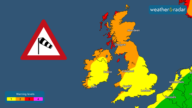
Gales are expected to affect many parts of the UK and Ireland Friday and Saturday

A deep low pressure system containing the remnants of Hurricane HUMBERTO will bring very strong winds to the north and west later this week.

The storm is likely to track just to the northwest of Ireland and Scotland, bringing a spell of very strong winds across the north late on Friday into early Saturday.

Gusts could reach over 90 mph in some coastal and upland areas of Scotland, with gusts between 45 and 60 mph elsewhere in the UK and Ireland.

Meanwhile, several spells of heavy rain will affect northern parts of Britain from this afternoon through late Friday as well.

Both the rain and the severe gales are likely to lead to some disruption and damage later in the week, particularly across the northwest and north.

Be sure to stay up to date and check your local forecast if you are in the affected areas.

How to activate warningsread more
Lars Lowinski
More on the topic
A wet start before conditions settle. Commonwealth Games 2026. . . Wednesday, 22 July 2026
Split image showing a weather map for western Scotland with widespread rain around Glasgow on the left, and runners poised at a starting line on an athletics track on the right.
Wednesday, 22 July 2026

Commonwealth Games 2026

A wet start before conditions settle
Drought across large parts of Europe. High fire risk. . . Monday, 20 July 2026
Split image showing a Europe rainfall anomaly map on the left with widespread dry conditions across much of the continent, and a cracked, parched field on the right alongside a wildfire warning symbol highlighting elevated fire risk.
Monday, 20 July 2026

High fire risk

Drought across large parts of Europe
Rain returns to end dry spell in places. Jet stream delivery. . . Thursday, 23 July 2026
Split weather graphic showing widespread showers across the UK and Ireland on the left, and a wind forecast map on the right with a windsock icon and gusts of 25 to 35 mph, highlighting breezy conditions across the two countries.
Thursday, 23 July 2026

Jet stream delivery

Rain returns to end dry spell in places
All weather news
This might also interest you
Bright and warm conditions take hold. Spring-like outlook. . . Thursday, 23 April 2026
Split UK map showing warm temperatures up to 21 degrees in orange on the left and clear sunny conditions with temperatures from 12 to 18 degrees on the right, with sun icons across the country.
Thursday, 23 April 2026

Spring-like outlook

Bright and warm conditions take hold
Historic Storm Éowyn arrives. On this day.... . . Saturday, 24 January 2026
Split image showing a person in a yellow jacket struggling against strong winds and heavy rain on a street at night on the left, and an Irish wind forecast map on the right with red and purple shading, gusts up to 75 mph, and a wind warning icon, divided by a curved white line.
Saturday, 24 January 2026

On this day...

Historic Storm Éowyn arrives
Flooding, gales, and heavy snow. Storm Chandra. . . Tuesday, 27 January 2026
Split image showing aerial flooding in a town with muddy water covering roads on the left, and a rural road on the right blocked by heavy snowfall with vans stopped and a person walking in snow.
Tuesday, 27 January 2026

Storm Chandra

Flooding, gales, and heavy snow
All articles
Weather & Radar

Weather & Radar is also available on

Google Play StoreApp Store

Company

Contact us Privacy Policy Legal info Accessibility statement

Services

Uploader

Socials

facebooktwittertikToklinkList